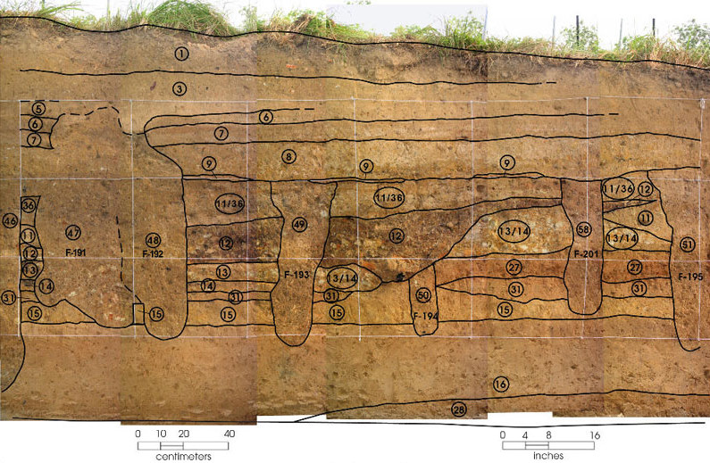
This photograph, a little farther from the center of the mound, shows many of the same things as the photograph to the left. Zone 16 is the natural ground below the mound. Zone 9 is a burned surface in the middle of the mound, and Zones 48, 49, 58, and 51 (also called F-192, F-193, F-201, and F-195) probably held posts for one or more buildings put on top of the Zone 9 surface. The remains of the earlier burned and collapsed building (Zone 12) are thicker here and partly rest on the two burned floors (Zones 13 and 14). On the right side, though, the building fell onto a low ridge of yellow and white earth that probably encircled the whole building. Zone 50 (F-194) below Zone 12 may be a posthole that went with the Zone 12 building, or maybe with another building on top of the layer of reddish dirt called Zone 27. It is hard tell which, though, because the Caddo removed most of Zone 27 when they excavated a shallow depression to hold the building that Zones 12, 13, and 14 represent.
This photograph does not show any burned surfaces in the upper part of the mound. This is partly because the top of the mound is sloping down and getting thinner, so it has been more affected by erosion. Disturbance from animal burrowing may be another factor. The archeologists decided that, because of its irregular shape, Zone 47 (F-191) might be where an animal dug into the mound and churned up the dirt after the Caddo left the site.