Woodrow Heard Site
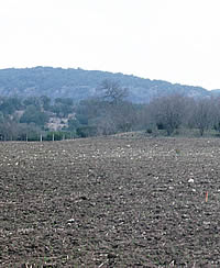
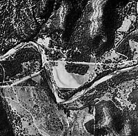
The Woodrow Heard site (41UV88) is a large campsite on the upper Dry Frio River in northern Uvalde County. Prehistoric groups stopped at this locality many times over a span of at least 8500 years beginning at the onset of the Early Archaic period. This site is one of many favored campsites within the sheltered canyons of the Western Balcones Canyonlands subregion of the Edwards Plateau. There, clear spring-fed rivers formed inviting oasis-like ribbons amid a rugged landscape that grows increasingly arid as one moves westward.
Archeologists from the Texas Department of Transportation conducted major excavations at the Woodrow Heard site in 1982-1983. Some years later, the site materials were analyzed and reported by Susan Decker and others from the Texas Archeological Research Laboratory; they also carried out geoarcheological trenching and sampling at the site in 1997. To learn more about the dynamic landscape revealed by the geoarcheological work, see the Dry Frio Dynamic Landscape entry [LINK to DL1]—here we’ll concentrate on the archeology.
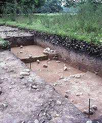
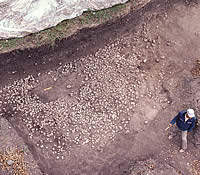
The Woodrow Heard site occupies a large river terrace and is a sizable campsite that prehistoric peoples visited repeatedly from the early part of the Early Archaic (ca. 7000 B.C.) through the Late Prehistoric periods. At least eight burned rock middens formed on the terrace, only one of which was partially excavated. Because the archeological investigations were restricted to the narrow limits of a road-widening project, we have a somewhat skewed understanding of the site. It isn’t really “a campsite” – rather, it is a camping zone and large river terrace upon and across which many different prehistoric visitors did many different things (hunted, gathered, camped, cooked, made tools, slept, and so on) over a vast 9,000-year stretch of prehistory.
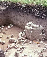
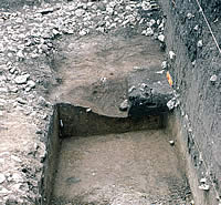
Archeologists documented and partially or wholly excavated 58 cultural features. All but one of these features were burned rock (cooking stone) accumulations and they ranged in size from tiny clusters of eight rocks representing very small basin-shaped hearths less than 2 feet (60 cm) in diameter to a massive burned rock midden over 65 feet (20 meters) in diameter. This midden represents an accumulation of cooking debris that formed over hundreds or perhaps thousands of years, The midden is the result of the repeated use of this spot as a cooking locality where heated rocks were used to bake plants (such as sotol and yucca) within earth ovens.
The river terrace on which people camped shows clear evidence that the river channel migrated and changed course several times during the long span of human history of this spot. Most noticeable is an abandoned channel that gradually filled with washed-in sediment while people continued to camp in the vicinity, sometimes baking plants in cooking pits dug into the fine sediments filling the abandoned channel. The relatively few and scattered artifacts and cooking features found within the in-filled channel proved informative to archeologists precisely because these materials were separated by thin layers of sediment. In contrast, elsewhere at the Woodrow Heard site the terrace surface was stable for long periods of time and accumulated very slowly. As prehistoric groups returned many times over the generations to camp on this river terrace, the debris they left behind during site use episodes hundreds or even thousands of years apart became mixed together.
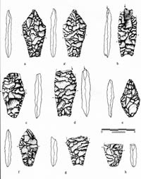
Because of how the site formed, the only discrete site component (a set of closely related materials left during a relatively brief period) dates to about 7,400-6,900 B.C. This Angostura component is named after the distinctive Angostura dart point, a lanceolate shaped projectile point that represents the last Paleoindian-style projectile point style in the region. The overall evidence, however, from the Woodrow Heard site and other sites in the region with Angostura components suggests that the lifestyle at the time was clearly part of the Archaic tradition.
Reference:
Decker, Susan, Black, Stephen L. and Thomas Gustavson
2000 The Woodrow Heard Site, 41UV88: A Holocene Terrace Site in the Western Balcones Canyonlands of Southwestern Texas. Studies
in Archeology 33, Texas Archeological Research Laboratory, University of
Texas at Austin. [Read Abstract.]