Upper Dry Frio
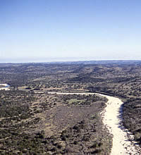
The upper valley or canyon of the Dry Fri River between Uvalde and Leaky, Texas lies within the Western Balcones Canyonlands, the jagged southern edge of the Edwards Plateau. Today people from across the state enjoy visiting the area, especially Garner State Park on the main Frio River. That clear spring-fed river lined with towering cypress trees has carved out a rugged canyon and is flanked by the characteristic limestone hills of the Texas Hill Country. The same scenic canyonland setting afforded by the Frio River and its lesser tributaries, including the Dry Frio, was favored by prehistoric peoples for thousands of years. But the landscape we see today has undergone many natural changes over time, a process that during the last 125 years or so we humans have tried with only partial success to control through dams, culverts, fences, clearing, planting, burning bans and so on. Let’s skip the human-wrought changes and look back at the area’s dynamic landscape in prehistoric times.
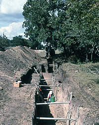
The natural history of the upper valley of the Dry Frio River in northern Uvalde County was studied as part of archeological investigations of the Woodrow Heard site (41UV88), an open campsite frequented by prehistoric groups for over 8,500 years. Geologist Dr. Tom Gustavson carried out what is known as a geoarcheological or geomorphological study of the archeological site and its surroundings. Such studies are part of modern archeological investigations because today’s “natural” landscape may appear very different from the natural landscape that existing thousands of years ago during the prehistoric era as the Dry Frio example illustrates.
To learn more about the archeology of the Woodrow Heard site, see the Ancient Place map layer [LINK].
Gustavson carried out his own fieldwork at the Woodrow Heard site. He studied the surface and topography of the archeological site and its surroundings and carefully inspected the exposures created by deep machine-dug trenches through the site. Laboratory analyses of sediment samples from the trenches, combined with the site’s radiocarbon dates allowed him to unravel how the landscape of this section of the Dry Fro River evolved since the Late Pleistocene geological era.
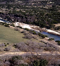
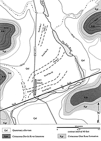
Over the last 15,000 years or so, the Dry Frio has changed its course repeatedly by “meandering” across its valley, sometimes gradually “migrating” (swinging) toward one side of the valley as floodwaters wash away (erode) the steep banks on the outer bends of the river. Sometimes the river moves abruptly and “jumps” its meandering channel during major floods and cuts a new, straighter channel. Through time the smaller side tributaries (creeks or arroyos) do essentially the same thing: meander and cut new channels. Over thousands of years, these migrations and meanders leave behind abandoned channels (swales) that gradually fill with debris and eroded soil. Each time the river makes a major change (jumps its channel) it gouges out a new path across the valley and exposes old filled-in swales (abandoned channels).
View a series of drawings by artist George S. Nelson demonstrating how a small section of the upper valley of the Dry Frio River changed through time.
Tom Gustavson is a quaternary geologist—meaning that he specializes in the recent geological history of the Earth and is a “soft rock” instead of “hard rock” geologist. In most settings, the most recent sediments (earth, sand, clay, etc.) are unconsolidated and have a long way to go before they turn to rock. By studying recent landscapes, quaternary geologists gain insight into the active processes that formed the many layers of the earth over millions of years. These same active processes—erosion, flood deposition, sand dune formation, etc.—continue to shape the natural world today as they have throughout human history and prehistory.
Geoarcheology is the application of geological techniques and expertise to answer archeological questions. Geomorphology is the study of the origin, evolution, and configuration of the natural features of the landscape.