Streamside Settlement
Abundant archeological evidence shows that the prehistoric peoples of the South Texas Plains lived along streams and rivers most of the time. Living debris is concentrated along the banks and low terraces of rivers, creeks and smaller tributaries. Flint flakes, Rabdotus land snails, mussel shell fragments, scattered fire-cracked rocks, projectile points, and chipped stone tools litter the intact surfaces of these locales. Where heavy erosion has occurred, substantial accumulations of debris can be seen in gullies and “hard pan” (compacted and eroded) surfaces exposed by sheet wash, often creating the illusion that these are “rich,” heavily occupied areas. Often these seemingly dense accumulations result from long-term erosion and soil loss; as the soil is washed and sometimes blown away, the heavier debris is winnowed and concentrated, giving a false impression of density.
These linear patterns of occupational debris fields mark the former campsites or temporary villages – which the Spanish called rancherias. Each pattern is not that of a single rancheria, but the combined debris of many encampments made in the same general area. The streamside settlement patterns perhaps can be best thought of as “occupation zones.” These can be a nearly a mile long, paralleling a stream course, an old river channel (oxbow), or atop a bluff near a dependable waterhole. Today streamside occupation zones are found along many small drainages that are bone-dry most of the time. This is clear evidence that surface water was much easier to find in prehistoric times, before the onset of modern land use practices. Drainages large and small are (or certainly were) heavily wooded areas with a variety of vegetation, that varies in composition depending on the size of the stream, soil depth, and where you are on the South Texas Plains. The region's overall rainfall pattern is wetter to the east and progressively drier to the (see Rainfall layer on main South Texas Plain exhibit map). Thus, there were bigger trees, wider woodland bands, and species adapted to moister conditions in the eastern part of the region along the San Antonio and Guadalupe rivers and their tributaries (see Morhiss Mound).
Looking westward, take the example of the Turkey Creek drainage on the Chaparrosa Ranch in Zavala County, west of the Nueces River. There the main creek and tributaries are lined with riparian woodland that includes oak, mesquite, white ash, Texas persimmon, guajillo, guayacan, granjeno and guayacan. The sites are on slightly elevated natural levees parallel to the stream, formed by overbank low-velocity floods and deposition of sediments. The fact that the campsites are large in area and very numerous is not a reflection of substantial prehistoric population levels; it is a consequence of repeated settlement patterns over thousands of years.
The mobile style of life dictated by hunting and gathering meant that people tried to be in the right place at the right time. Individual groups or bands – perhaps a few families numbering 50-150 people – had to make use of their intimate knowledge of the terrain, the seasonality of ripening wild fruits, the places where game was abundant and so forth. With this knowledge, they planned their daily activities. They knew well that many food resources could be obtained within the streamside environment – deer coming to water; rats and rabbits living and hiding in the dense undergrowth; nuts, fruits and roots from plants found in the valleys; mussels, fish and turtles in the waterways, etc. At many sites in the Chaparrosa Ranch area, the adjacent floodplain is filled with prickly pear (“pear flats”), and the use of the ripe prickly pear fruit, or tuna, is well documented in Spanish accounts. Of course, other food resources were found in the uplands and flat prairies lacking surface water, but these would have been reached during relatively short trips away from the streamside base camps – hunting forays by men and food-collecting excursions by women and children.
The provenience of a streamside occupation zone depended very heavily on exchange of information with neighboring groups and within the group itself. Glimpses of the importance of information sharing comes from ethnographic studies among the Australian Aborigines and the San (Bushmen) of southern Africa. In these hunting and gathering groups, the men go out to hunt and the women and children collect plant foods, small animals, and dig up roots. In the evening around the smoky campfires, they talk about what they observed during the day: animals using a certain waterhole, a favorite traditional hunting area in which game is scarce, a grove of trees loaded with nuts, a greener area where localized rain has fallen. All of this information is shared among the group, and sometimes with visiting members of other groups, and used to plan hunting and gathering activities and strategies for the next day and for the days ahead. Today we think of ourselves as quite sophisticated, but how many of us would survive for long as hunters and gatherers?
Such sites were used over and over again through the thousands of years of the Archaic and Late Prehistoric eras. For most specific occupation localities and sites we do not have enough information to pin down what seasons of the year they were used. We can predict that, through time, the seasonal timing and desirability of rancheria locations waxed and waned along with localized rainfall patterns and long-term climatic patterns. The resources around preferred campsites, however abundant, would not last very long, and soon the group would have to move up or down the stream to another productive “zone.”
Archeological excavations and controlled surface collections have shown that there might be a concentrated Late Prehistoric occupation in one area, a Late Archaic occupation in another, and yet an earlier Archaic deposit in another spot --- all within one “occupation zone.” To cite just two known examples of this pattern, this is clearly the case at the Mariposa site (41ZV83; 30 meters wide, 200 meters long) on Turkey Creek on the Chaparrosa Ranch in Zavala County as well as at the Possum Hollow site on a slough of the Frio River (50-60 meters wide, 800 meters in length) at Choke Canyon Reservoir.
In the South Texas Plains, these streamside occupations are rarely stratified (layered) as is more often the case in many central Texas sites or within the constraints of the large dry rockshelters in the Lower Pecos Canyonlands. In the South Texas Plains, most sites have to be intensively studied from a “horizontal” perspective, and in this fashion, the use of various parts of an occupation zone can be studied by chronological indicators and function-specific "activity" areas. This would be possible at many sheet-washed sites on the South Texas Plains, making such sites quite valuable for research.
Sadly, these archeologically fragile areas are highly susceptible to intensive projectile point collecting, a favored pastime of many South Texans for generations. With each passing decade there are fewer and fewer streamside occupation zones with intact archeological patterns. Bit by bit, meaningful traces of the human history of the region are taken from the landscape, and most are never learned from.
Contributed by Thomas R. Hester
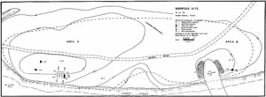
The Mariposa site on Turkey Creek on
the Chaparrosa Ranch in eastern Zavala County is a good example of a streamside occupation zone, a
general area or band along the creek where prehistoric groups established rancherias (temporary
encampments) from time to time over several thousand years. From 1978 report by John L. Montgomery,
The Mariposa Site: A Late Prehistoric Site on the Rio Grande Plain of Texas, Center for
Archaeological Research, UTSA, Special Report 6.
|
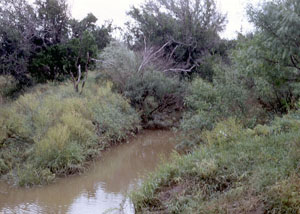
Turkey Creek in Zavala County
illustrates the riparian environment which drew ancient peoples to live nearby. This photo was
taken during an archeological field school from the University of Texas at San Antonio in the summer
of 1975. Students amused themselves by catching crawfish in this muddy hole during the lunch break.
Photo by T. R. Hester.
|
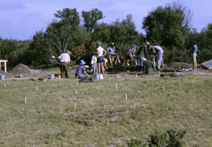
UTSA field school excavations at site
41ZV10, another streamside occupation zone. The dense riparian vegetation visible in the background
would have once covered the entire area shown; the excavation area was situated in a cleared area
maintained by the rancher for his cattle. Photo by T. R. Hester.
|
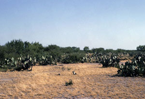
Prickly pear flat flanking a
typical streamside occupation zone in Zavala County. Photo by T. R. Hester.
|
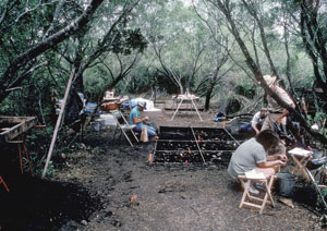
Excavations in progress at the Batot-Hooker
site, a streamside occupation zone in southern Medina County. Here the riparian vegetation is quite
thick as is the dark midden soil left by repeated occupations. Photo by T. R. Hester.
|