Keystone Dam
The Keystone Dam site is located on an alluvial fan adjacent to the floodplain of the Rio Grande in the northwest part of El Paso, near the Franklin Mountains. It served alternately as a camp and storage site during the Middle Archaic period and a seasonal desert succulent processing site during the Formative period. The Middle Archaic component serves as the key example of a residential base camp for settlement system studies of the Middle Archaic period and, because of its early house structures, is considered one of the most significant sites in the southern Southwest.
The site takes its name from the Keystone dam, one in a series of five dams that was erected on the Rio Grande between 1979 and 1980 to prevent flooding in the Upper Valley. The Keystone Dam site is just one of 18 sites in the immediate area, but it is the largest and most important. It was discovered in 1974 following a survey of the proposed construction sites for the Keystone and Mesa dams. The first excavation of the site was undertaken in 1979 by the El Paso Centennial Museum of the University of Texas at El Paso for the U.S. Army Corps of Engineers. The site was determined eligible for the National Register of Historic Places and the design of Keystone dam was altered to avoid covering the main part of the site. In 1984, a small portion of the site was excavated by the El Paso Archaeological Society. Thomas O’Laughlin was the project archeologist for both excavations.
Middle Archaic peoples lived intermittently at Keystone Dam from 2500 to 1800 B.C. Later peoples visited the site seasonally between 160 B.C. and A.D. 1500. The Middle Archaic component of the site is the more important of the two, because it has produced the earliest house structures documented in the southern Southwest, and some of the earliest evidence for semisedentary settlements in all of the Southwest. Traces of 23 huts have been identified, but O’Laughlin estimates that there may be 18 more in the uninvestigated portions of the site.
The huts were built in shallow pits and consisted of brush domes constructed with wood from a variety of small trees and shrubs, including mesquite, tornillo, cottonwood, creosote, wolfberry, and Apache plume. They were thatched with grass, then covered with burned mud plaster that was made with grass stems, leaves, and small branches.They had unprepared floors that contained small, informal hearths.
The huts measured only about 3 meters (10 feet) in diameter and were clustered in small groups of two to five. This suggests that each hut was occupied by a nuclear family and that each cluster represents an extended family household. It is not known whether these clusters represent different, subsequent occupations by small extended family-sized groups, or a single, prolonged occupation by a larger band-sized group. Traces of 29 burned rock hearths were found interspersed among the huts.
Keystone Dam is situated in close proximity to six distinct environmental zones, each of which has a different combination of economically important plant foods. The Middle Archaic people who visited the site exploited a variety of these plants, including sotol, lechuguilla, prickly pear, smartweed, dock, amaranth (pigweed), tansy mustard, acacia, Turk’s cap, bulrush shoots, goosefoot seeds, purslane seeds, tornillo beans, and mesquite beans. Though the campers would have had access to both the creatures of the land and the fish, turtles, and migratory water fowl of the Rio Grande, only rabbit bones and bird eggshell were recovered from the Middle Archaic component of the site. Poor preservation conditions likely account for this scarcity of animal bones.
The Middle Archaic people of Keystone Dam produced technologically simple chipped-stone tools from local raw materials. These expedient tools were flexible enough to be used for a variety of tasks and show evidence of extensive reworking and reuse, rather than discard after use.
O’Laughlin has interpreted the Middle Archaic component of the site as a non-permanent base camp for a people with an economy built around a central based wandering pattern. During the late spring, summer, and fall, the people who constructed the huts used them as storage sites for plant resources that they gathered locally and in other localities. During the winter and early spring, they used the huts as dwellings and subsisted on the resources that they had stored, while exploiting plants that become plentiful along the Rio Grande and in the Franklin Mountains during the cooler months.
The Formative component of Keystone Dam is much more ephemeral than the Middle Archaic component. It is typified by a limited range of specialized, extractive activities centering on the use of earth ovens. Over 190 burned rock features have been identified from the Formative component and there may be an equal number in untested areas of the site. They are the remains of earth ovens that were used for brief periods in the spring to bake desert succulents such as sotol and lechuguilla.
In addition to desert succulents, the Formative visitors to Keystone Dam exploited mesquite beans, tornillo beans, wolfberries, and the young shoots of cattail and bulrush. Faunal preservation from this occupation is exceeding poor, and only the remains of rabbit have been recovered.
Chipped-stone tools from the Formative component of Keystone Dam, like those from the Middle Archaic component, were expedient and made from local materials. But unlike the Middle Archaic tools, the Formative tools were reused less frequently and were probably discarded after use. They were also less generalized and appear to have been geared specifically toward the processing of desert succulents.
Few ceramics were recovered from the Formative component of the site, but their styles span the entire Formative period. Earlier types include the local El Paso Brown, Alma Plain, and San Francisco Red types, and the intrusive Mimbres Black-on-White and corrugated ware. Later types include the local El Paso Brown with black painted lines and El Paso Polychrome, and the intrusive Rio Grande Glazes A and F.
During the Middle Archaic period, Keystone Dam served as a winter camp and storage site for generalized hunter-gatherers who exploited a variety of plant resources. During the Formative period, it was used intermittently as a desert succulent processing site in the spring. The use pattern of the site fits with the wider settlement pattern for the Rio Grande valley, in which Archaic residential sites are usually on the east side of the river, because the number and seasonal availability of plant resources is greater on that side. Formative residential sites are typically on the west side of the river, because that side is more amenable to agriculture, while specialized extraction sites tend to occur on the resource-rich east side.
Today, the Keystone Dam site is owned by the city of El Paso and managed by the Keystone Heritage Park. Keystone Heritage Park plans to restore the wetlands surrounding the site and turn the area into a park, complete with nature trails, botanical gardens, a wildlife rehabilitation and release center, and an educational laboratory. Visitors will have the opportunity to watch archeologists excavate the site and reconstruct portions of its Archaic component. For more information, visit the Keystone Heritage Park’s website.
Contributed by Carly Whelan based on a report by Thomas O'Laughlin and other sources cited below. Photos provided courtesy of the Centennial Museum, University of Texas at El Paso.
Sources
O’Laughlin, Thomas C.
1980 The Keystone Dam Site and Other Archaic and Formative Sites in Northwest El Paso, Texas. El Paso Centennial Museum Publications in Anthropology 8, University of Texas at El Paso.
2002 Keystone Dam Revisited. Archaeological Society of New Mexico 28:57-66.
Miller, Myles R. and Nancy A. Kenmotsu
2004 Prehistory of the Jornada Mogollon and Eastern Trans-Pecos Regions of West Texas. In The Prehistory of Texas, edited by Timothy K. Perttula, pp. 205-265. Texas A&M University Press, College Station.
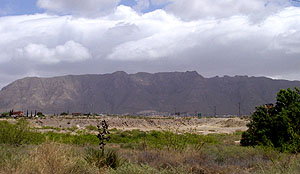
View of the nearby Franklin Mountains. Middle Archaic people spent the winter at Keystone Dam and gathered plants that become plentiful in the mountains during the cooler months.
Photo by Susan Dial. |
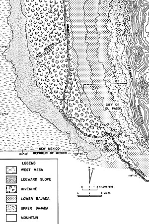
Keystone Dam is situated between the Franklin Mountains and the Rio Grande, in close proximity to six distinct environmental zones. Each of these zones has a different combination of economically important plant foods that were exploited by the people of the site. Graphic from O'Laughlin 1980, Fig. 5. |
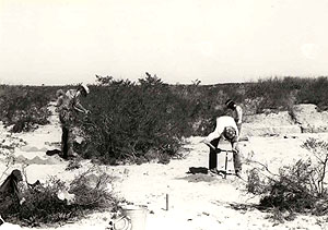
Archeologists from the El Paso Centennial Museum at work at Keystone Dam in 1979. Before they begin excavating, they core the site with soil augers to help them locate underground features. Photo courtesy of the Centennial Museum, University of Texas at El Paso. |
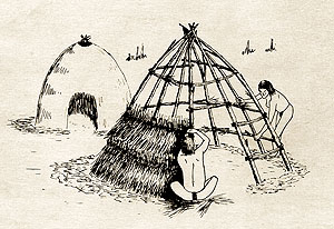
An artist’s conception of the huts at Keystone Dam. The hut in the foreground has a completed wooden frame and is being thatched with grass. The hut in the background has already been thatched and awaits a coating of mud plaster that will help insulate it during the winter. Graphic from O'Laughlin 1980. |
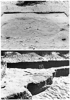
View of two of the excavated Middle Archaic huts. Note the postholes around their perimeters. This is all that remains of the wooden frameworks of their domes. Photos from O'Laughlin 1980, Fig. 33. |
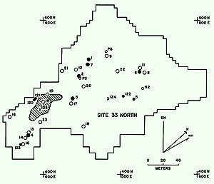
Locations of the huts and burned rock hearths from the Middle Archaic component of Keystone Dam. The houses are clustered into groups of two to five, suggesting that each hut was occupied by a nuclear family and that each cluster represents an extended family household. Graphic from O'Laughlin 1980, Fig. 20. |
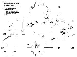
Locations of the 190 burned rock features from the Formative component of Keystone Dam. They include both cooking hearths and earth ovens that would have been used to bake desert succulents such as sotol and lechuguilla. Graphic from O'Laughlin 1980, Fig. 18. |
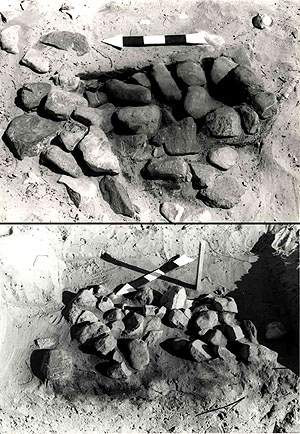
Cooking hearths from the Formative component of Keystone Dam. Photographs courtesy of the Centennial Museum, University of Texas at El Paso. |
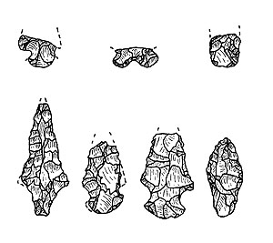
The few projectile points recovered from Keystone Dam. They were made from local raw materials. Graphic from O'Laughlin 1980, Fig. 37. |
Cover of Thomas O'Laughlin's 1980 Keystone Dam report. |