Lag Gravels
Lag gravels are surface accumulations of coarse gravel created by the erosion of finer particles. They represent gravels deposited by ancient rivers that crossed the region hundreds of thousands or even millions of years ago, washed from source areas hundreds of miles distant. Since then, these ancient waterways have been all but obliterated by geological processes, especially erosion and the continuous landscape remodeling done by the drainage systems we can see today.
Deposits of lag gravels can be found in many places across the Trans-Pecos. Major sources include the undulating surface of the Marfa Plain and the Rio Grande basin. Perdiz Formation outflows during Tertiary volcanism in the Big Bend probably accounts for some of the lag gravel exposures found to the east and north of the Chinati MountainsThey are also found as bedload gravels in streams. Because these gravels originated in many different geological formations they are diverse in composition. Cherts, agates, felsites, jaspers, and many other fine and coarse grain rocks are present. In most deposits, the gravels are relatively small in size, but still contain many pieces large enough to be fashioned into stone tools.
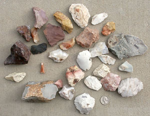
Lag gravels from Presidio County south of Marfa. Photo by Bobby Gray. |