The Archeology: Site Description, Stratigraphy and Dating
|
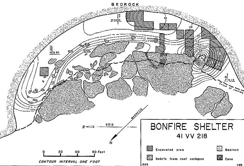
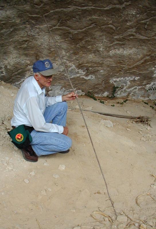
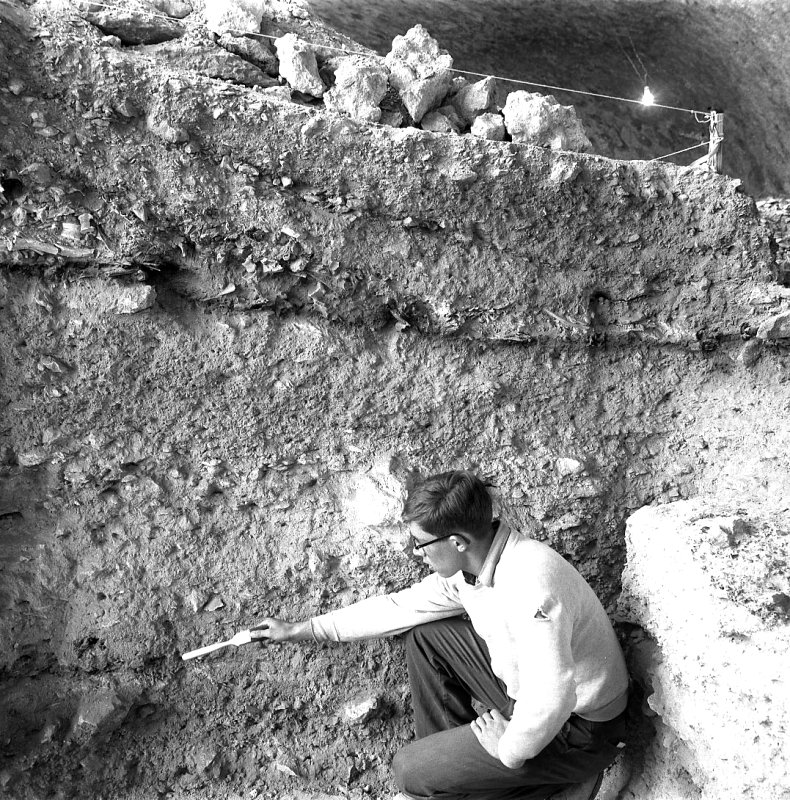
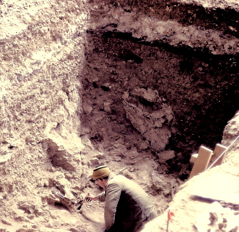
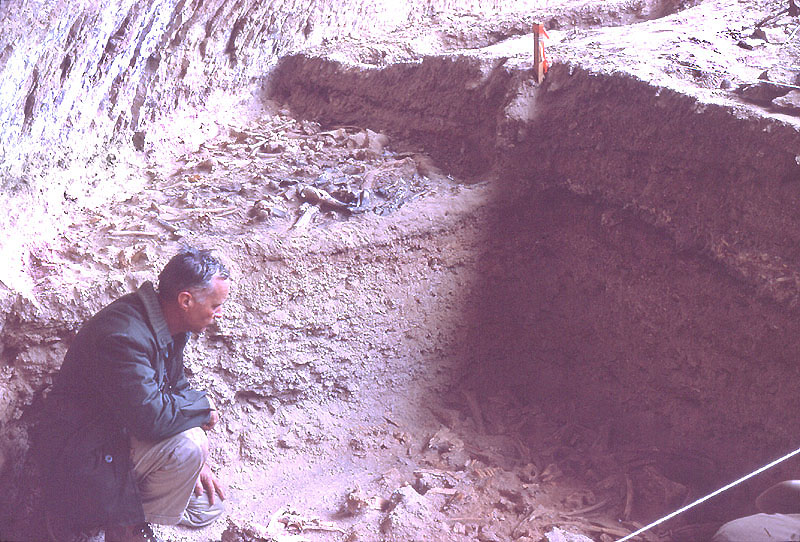
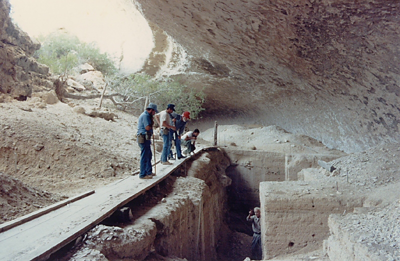
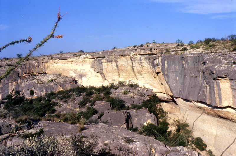
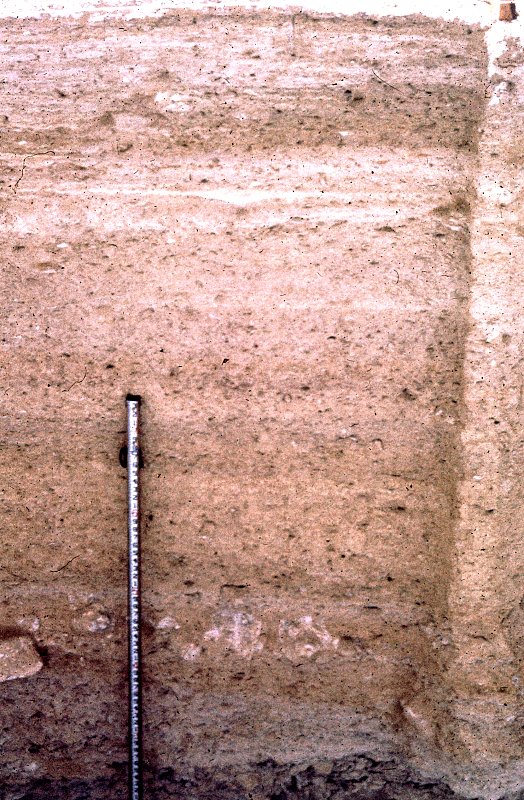
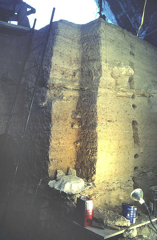
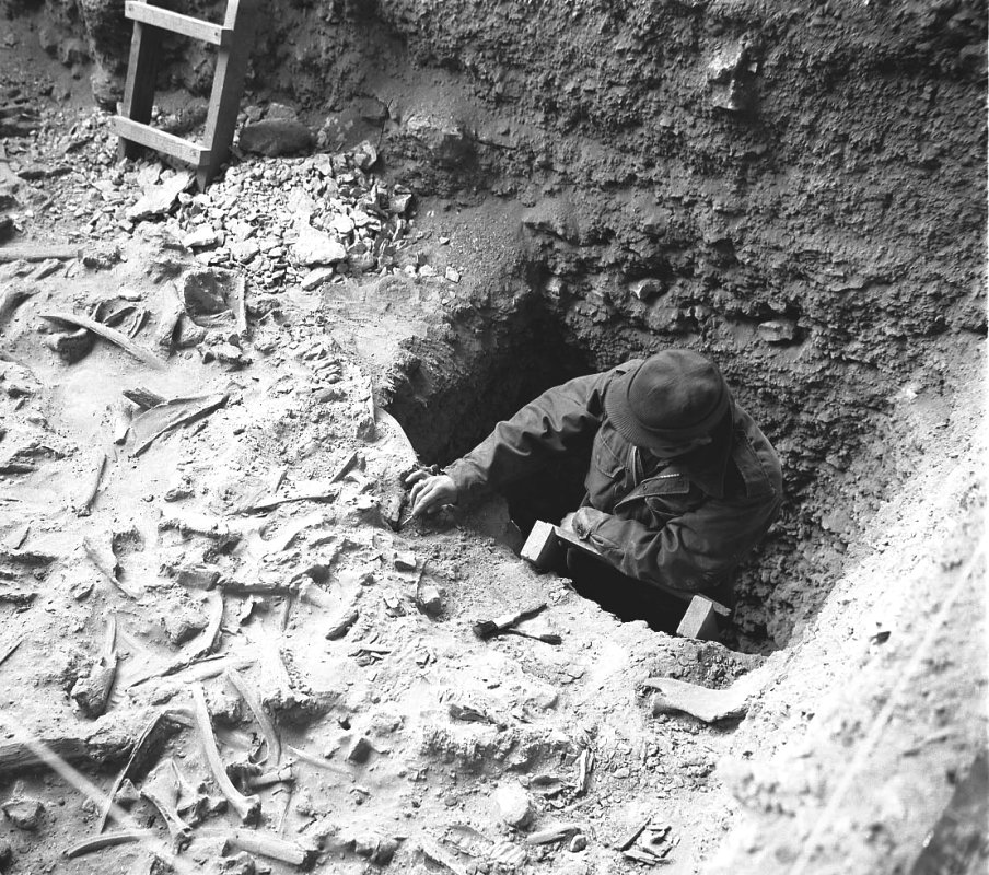
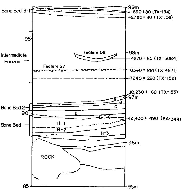
This section contains a fairly detailed description of Bonfire Shelter's deposits as well as information about the site's radiocarbon dates. This kind of technical detail matters a great deal to archeologists and anyone who really wants to understand how and when the site's deposits formed. If you don't have the time or interest for the details, you might want to read the first part and take a look at some of the photographs and the map or just Explore Bonfire. Physical DescriptionBonfire Shelter is crescent-shaped when viewed from above ("plan view") with a wide "mouth" (opening) almost 300 feet (about 90 meters) across. Most of the shelter's mouth is blocked from view by a series of giant roof blocks, huge chunks of limestone that were once part of the shelter's roof. Behind the fallen roof blocks, the floor of the shelter slopes toward the back or rear of the shelter, an unusual configuration. The floor of the shelter varies from less than 80 feet wide to more than 200 feet in the middle of the shelter. Apart from the roof blocks, the most prominent topographic feature in Bonfire Shelter is the cone-shaped debris pile ("talus cone") directly beneath the notch in the cliff. Many of the buffalo in Bone Bed 3 landed atop the talus cone and tumbled into the cave. Because of the roof blocks and the talus cone as well the brush and small trees growing around these features, Bonfire Shelter is all but invisible from the canyon floor below. To get an idea of what the place looked like before the archeological work began, look at the site map and try to ignore the shaded excavation units and look closely at the contour or topographic lines which are drawn at 1-foot intervals. The contour lines are shown only for the parts of the shelter that had buried deposits; the stippled roof blocks at the front of the shelter jut up from the "floor" as can be seen in the photographs. The most dramatic topographic feature shown by the contour lines is the talus cone situated directly under the cleft in the cliff above the shelter. Follow the contour lines down from the high point and you will see that the lowest part of the original surface of Bonfire Shelter is actually at the back of the shelter, rather than at the front as is often the case with most rockshelters. Long, long ago the floor of Bonfire Shelter did indeed slope downward from back to front in the typical fashion. But the collapse of part of the roof sometime prior to 14,100 years ago left behind the giant roof blocks which, in effect, created a dam that held in sediment and small roof spalls that otherwise would have tumbled into the canyon. The careful profiles or cross-section drawings made during the 1963-1964 excavations show how Bonfire Shelter's deposits vary in thickness and extent. The DepositsThe natural and cultural deposits within Bonfire Shelter are complex and are thought to reach a maximum depth of at least 22 feet (7 meters) below the modern floor of the shelter. Archeological excavations have only penetrated through the upper 13 feet (4 meters) of the shelter's deposits, but landowner Jack Skiles drove an iron rebar down nearly 10 feet (3 meters) before encountering impenetrable rock. It is not known whether he reached bedrock or a large boulder. In any case, the deepest known deposits consist of stream-rolled gravels, suggesting that the shelter was periodically flooded prior to the formation of the site's earliest known bone beds. At the level in which the first bone bed began accumulating (at least 14,100 years ago and probably considerably earlier) there is no evidence of major flood episodes in the shelter deposits, suggesting that the canyon floor had been cut down (by erosion through bedrock) well below the shelter. All of the deposits containing animal bone and all those containing definitive evidence of human occupation seem to have been formed by a combination of natural and cultural processes. Most of the deposits in Bonfire Shelter consist of limestone spalls (rocks that peeled or "spalled" off the shelter roof and rear wall) and pale-colored silt that represents decomposed limestone bedrock. The massive rocks piled along the front of the shelter represent a major collapse of the original roof of the shelter. This potentially catastrophic event (probably several events) occurred well before humans began using the shelter. We know this because none of the cultural zones appear to continue under the rock fall, but instead butt up against the rocks. The fallen rocks formed a natural barrier or wall that closed in the mouth of the shelter. Because of this feature, Bonfire Shelter is practically invisible from the canyon floor. The fallen rocks also help prevent sunlight from striking most of the shelter, making Bonfire relatively cool, especially in the winter. Other than the huge rocks at the mouth of the shelter, the most prominent topographic feature in the site is the cone-shaped debris pile directly beneath the cleft or notch in the cliff. This pile of rocks and sediment is called a "talus cone," and it accumulated periodically when locally heavy rains caused lots of water to drain off the cliff through the notch, leaving behind a layer of dirt and rocks. The rocks and debris deposited by the runoff formed the talus cone (the rock pile and the steeply sloping deposits around it). The talus cone also helped block sunlight into the shelter and served as a dam that prevented water from draining out of the shelter. This helps explain why Bonfire Shelter is relatively wet compared to most other large rockshelters. The excavation profiles from the 1963-1964 investigations show how Bonfire Shelter's layers relate to one another in different areas of the shelter. Start with the plan map showing the location of the excavation units within the rockshelter. By comparing various profiles you will see that the site's deposits were deeper in some areas of the shelter than others and that the layers sloped steeply in some areas, while they were more or less flat in others. The site's major stratigraphic layers are briefly described below, from bottom to top, using the scheme devised by Dave Dibble. Zone 1 is the thick, lower portion of the shelter's deposits below Bone Bed 2 within which various smaller strata (lenses) occur. The two closely spaced layers of bone that Dibble collectively called Bone Bed 1 lies within his Zone 1. Based on more-extensive exposure with better lighting, the 1983-1984 excavators divided this lower zone into at least six strata (only the first five of which were labeled). To avoid confusion with the original numbering system, they assigned letters to the strata they encountered beginning with the uppermost layer of Bone Bed 2 (Stratum A) and continuing to Stratum I, the lowest bone-bearing layer. But still deeper was a thick deposit containing boulders and fine stream-rolled gravels that was not designated as a stratum and the bottom of which was not encountered. Unfortunately, the revised stratigraphy of Zone 1 has yet to be fully published. Based on the 1983-1984 work, five bone-bearing strata were defined below Bone Bed 2, within and below Zone 1 as encountered and described by Dibble. These include Strata D, E (arbitrarily divided into E, F and G), H-1, H-2, and I. There is no conclusive evidence that humans were present at Bonfire Shelter during the accumulation of Zone 1, although several lines of evidence led both groups of investigators to hypothesize that humans played a part in the accumulation of bones in several of the layers within the original Bone Bed 1. Bone Bed 2 is the major Paleoindian-era bone layer composed almost entirely of the bones of an extinct form of bison mixed with cave dust. In some places it consisted of three lenses of bone, but in others only a single layer was apparent. Because of the three lenses (labeled Strata A-C by the 1983-1984 excavators), it is inferred that at least three bison jumps contributed to Bone Bed 2. Because of the lack of an intervening layer of silt or roof spall, it is thought that comparatively little time elapsed between Paleoindian jump events. Still, sediment generally accumulated slowly in the shelter and several hundred years or more could have elapsed without noticeable sediment accumulation. Zone 2 is a thick, relatively homogenous layer consisting mainly of natural silt and roof spalls. Within Zone 2, the original excavators recognized what they termed the "Intermediate Horizon" consisting of two fire hearths, a few stone tools, and a possible living surface. The later investigators found several other hearths that did not appear to be directly related to those reported by Dibble. Collectively, the Intermediate Horizon appears to represent a series of minor occupational events that occurred sporadically during the roughly 8,500 years between Bone Beds 2 and 3. Bone Bed 3 is the massive bone bed dating to the Late Archaic that was burned so intensively that many of the bones were reduced to ash. There is some question as to whether Bone Bed 3 represents a single, massive bison jump episode or several successive episodes. There is no compelling stratigraphic evidence of the latter possibility, but Dibble and several other archeologists familiar with the site thought it unlikely that such a massive deposit of bone could result from a single event. Zone 3 is another thick and relatively homogenous layer consisting mainly of natural silt and roof spalls. Within Zone 3, a thin, intermittent layer of perishable material known as the Fiber Layer was documented at the southern end of the shelter. DatingThis schematic diagram profile shows the approximate stratigraphic relationship among certain of the site's major depositional zones and seven of the site's radiocarbon assays. The twelve radiocarbon assays that have been obtained from wood charcoal samples are presented in the Radiocarbon Table. Additional assays on charred bone were obtained, but these are considered unreliable. Readers unfamiliar with radiocarbon dating may want to read the glossary entry or see the TBH Special Exhibit Radiocarbon Dating Understood. The ages discussed below are calibrated calendar ages. The earliest bone deposits (Bone Bed 1 and Strata E through H-2) have yielded only a single radiocarbon assay with a calibrated age of 13,032-12,414 B.C. (range of 3 midpoints). This date falls a thousand years or more earlier than the oldest accepted age of Clovis culture (about 11,500 B.C.). Bone Bed 2 produced four radiocarbon assays on charcoal, three from Hearth 1 and one from scattered charcoal, but all from the uppermost part of the deposit providing a minimum age estimate. The calibrated midpoint ages of these four assays range between 9308-10,146 B.C., but assays overlap at the 1-sigma (66.6% probability) level between 9,680-9,692 B.C., suggesting a minimum age of at least 11,680 years old. The finding of a Folsom point in the lower part of Bone Bed 2 suggests that the earliest Paleoindian bison jumps could date several hundred years earlier. There are three assays on charcoal from three hearths exposed in the Intermediate Horizon yielding the following calibrated mid-point ages: 6156-6076 B.C., 5316 B.C., and 2888 B.C. None of the assays overlap at the 2-sigma level, suggesting that they represent events widely separated in time during the Early and Middle Archaic or the Viejo and Eagle Nest periods defined by Dibble. It is reassuring to note that the dates fall in correct stratigraphic order, youngest to oldest being also highest to lowest. Bone Bed 3 is dated by two assays on charcoal, with calibrated midpoint ages of 917 B.C. and 762-602 B.C. (five midpoints). Although the 2-sigma date ranges overlap between 833-788 B.C., the overlap lies at the ends of the probability curves, meaning that there is only a relatively small probability that the two assays are dating the same event. Said differently, the two radiocarbon assays could be interpreted as support for the notion that Bone Bed 3 is the result of at least two events separated by several hundred years. Both fall within the Late Archaic or the Cibola period as defined by Dibble. Two charcoal dates from the Fiber Layer yielded calibrated midpoints of A.D. 362-383 (three midpoints) and A.D. 652. The 2-sigma calibrated ranges overlap between A.D. 406-541, but as with the Bone Bed 3 assays, the overlap falls at the ends of the probability curves and the assays could well represent two different occupational events. These age estimates fall at the end of the Late Archaic or within the Blue Hills period defined by Dibble. |
|