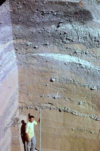
Thousands of years of intermittent
human occupation can be seen in the walls of this incredibly
deep archeological excavation at Arenosa Shelter. Because
this site is located on a low terrace of the Pecos River,
periodic floods left behind thick deposits of tan silt.
Between the major floods are equally thick gray, ashy
midden deposits created by prehistoric peoples. This
early morning photo brings out colors often muted by
the intense sun. This 1966 photograph from the ANRA-NPS
Archives at TARL was probably taken by Dave Dibble;
the young archeologist holding the stadia rod is Mark
Parsons. |
|
The jagged canyonlands they called home contain
an extraordinarily rich cultural legacy of ordinary
and extraordinary things that are rarely found in most
other areas of North America. |
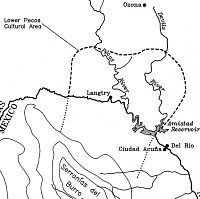
The approximate area of the Lower
Pecos archeological region as defined by archeologist
Solveig Turpin. The southern limit is not precisely known, but believed
to be in the Burro Mountains in Coahuila. |
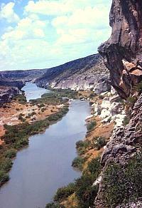
The Pecos River gives the Lower Pecos
its name and provided natural shelter in hundreds of
rockshelters along its canyon walls and those of its
many side canyons. Photo from ANRA-NPS Archives at TARL. |
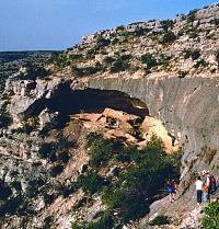
Archeologists carefully make their
way across a steep rock slope to join the excavations
at Baker Cave, a large occupation shelter located in
a side canyon of the Devils River. Photo by Tom Hester. |
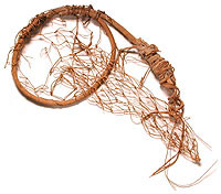
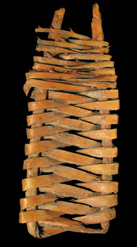
Miniature netted pack frame perhaps
used by a child. From the ANRA-NPS collections at TARL. |
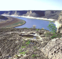
View of the lower Devils River valley
now partially filled by Amistad Reservoir. In prehistoric
times, the wider terraces along this stretch of the
river were shaded by massive oak trees and were a favored
camping spot. Photo by Steve Black. |
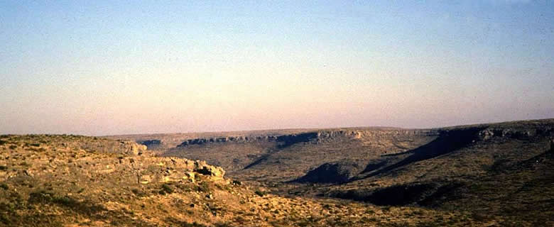
Spectacular view of one of the large side canyons of the
Rio Grande. These create sheltered environments with a
concentration of water, plants, animals, and, in prehistoric
times, people. Photo by Steve Black. |
|
The Lower Pecos Canyonlands is one of the most distinctive
and significant archeological regions in Texas and, indeed, in North America. It is not
that the Indians who once lived here were particularly important or unusual—they
were just ordinary folk like many others all across the prehistoric landscape. But due to a unique combination of ecological and geological
factors, the jagged canyonlands they called
home contain an exceptionally rich cultural legacy of ordinary
and extraordinary things that are rarely found in most other
areas of North America—perfectly preserved food remains,
vivid rock art over 4,000 years old, grass-lined beds, painted
deer bones, and much more. By studying these things and the
places where they are found, researchers from many disciplines—archeologists,
anthropologists, biologists, art historians, paleontologists,
geologists, and others—are piecing together a remarkably
detailed understanding of the human and natural past.
Although the Lower Pecos Canyonlands contains a uniquely
vital cultural legacy of worldwide importance, many Texans
don't even know it exists. Sadly, among those who do are some
who rip apart its caves out of greed and stupidity and crudely
carve their names on ancient works of art. Those who explore
this exhibit will understand how senseless and tragic these
thoughtless actions are. Perhaps as more people appreciate
what can be learned about the cultural heritage of Texas in
this unparalleled place, the sites that remain unharmed will
be protected for the future.
This exhibit provides an overview of the Lower Pecos Canyolands and introduces some
of the places and topics that are explored in greater depth in
three other companion exhibits on this website. A special exhibit—Ethnobotany of the Lower Pecos Canyonlands—details the many ways that native peoples made use of the region's wild plants. Major exhibits on two of the
most amazing and best known archeological sites in the Lower
Pecos—Bonfire Shelter and Hinds Cave —illustrate what can be and has been learned by
thoughtful study.
Lower Pecos Canyonlands
Here we choose to use the evocative term "Lower Pecos Canyonlands" or simply the "Lower Pecos" instead of the technical term often favored by archeologists: the "Lower Pecos archeological region." Archeological regions (sometimes called "cultural areas") are geographic areas that are distinct
in the minds of archeologists because of the similarities
they observe in culture, artifacts, geography, climate, and other interwoven
factors. In some areas of the state, archeological regions
are very broad and cover many hundreds of square miles—the
Caddo area, for example, covers much of northeast Texas and
adjacent areas of neighboring states (see Caddo Map Tool). In contrast, the Lower
Pecos Canyonlands covers a much smaller territory—the
area surrounding the junctions of the Pecos and Devils Rivers
with the Rio Grande just upstream from Del Rio, Texas. Although
the best-known part of this area lies in Texas, the archeological region extends southward into northern
Coahuila, Mexico.
The three rivers and their many tributaries form
deeply incised canyons within which numerous rockshelters
occur. Although the region is arid, averaging less than 15
inches of rain per year, the rivers as well as springs and
temporary waterholes called tinajas within the smaller
canyons provided reliable water sources. For over 13,000 years
prehistoric hunter-gatherers lived in the region, sometimes
occupying the rockshelters. The generally dry conditions coupled
with the protected rockshelters resulted in the preservation
of fragile materials such as wooden artifacts, woven sandals,
and plant food refuse that decay quickly in most other areas
of Texas.
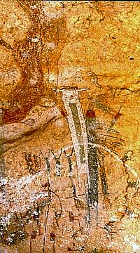
But the most spectacular and defining archeological
phenomenon in the Lower Pecos Canyonlands is the vivid rock art that adorns
the protected walls of many of the rockshelters. The red,
black, white, and yellow images created by hunter-gatherers
in the Lower Pecos beginning as early as 5,500 years ago are
among the best preserved examples of rock art anywhere in the world. The
art and archeology of the region is truly world class,
providing archeologists with the opportunity to study the
remains of prehistoric gathering and hunting cultures in far
greater detail than is possible elsewhere in Texas and in
much of the world.
In this Exhibit
The Natural
World of the Lower Pecos Canyonlands is a curious place where permanent
sources of water can be found a short walk from an arid landscape
that may wait months or even years between periods of adequate
rain. Each of the rivers—the Pecos, the
Rio Grande, and the Devils—originate beyond, sometimes far, far, beyond
the region, giving each a distinct character. Yet the rivers
and their tributaries form narrow ribbons of oasis-like
abundance that twist and turn through the rocky and often
waterless limestone terrain of the canyonlands. Many of the plants and animals
found here are at the outward limits of their distributions—the
Lower Pecos lies at the intersection of ecological zones stretching
north, east, south, and west.
Most of the evidence we have about the human
past in the Lower Pecos Canyonlands comes from Rockshelters,
natural shelters large and small that occur in great numbers
within the rocky canyonlands of the region. Although it might
seem that way, the prehistoric inhabitants of the region did
not spend most of their lives in rockshelters. They lived
throughout the canyons and high above in the uplands where
grasslands once thrived. But, the rockshelters provided refuge
during times of harsh weather and, more importantly for archeologists,
the rockshelters protected the fragile remains left by prehistoric
peoples from the ravages of time.
Above all else, the Rock
Art of the Lower Pecos Canyonlands is its most distinctive and defining
feature. The rockshelters and other protected rock surfaces
provided the canvases upon which prehistoric and early historic-period
Indian artists created some of the world's most remarkable
"primitive art." While the cultures that produced
the paintings and carvings may be considered primitive at
least in a technological sense, the rock art is incredibly
sophisticated and complex. Hundreds of different motifs and
symbols occur representing at least four major styles, the
earliest and best known of which, the Pecos River style, began
perhaps 5,000 to 6,000 years ago.
The hunting and gathering Economy
of the prehistoric peoples of the Lower Pecos Canyonlands can be studied
in great detail due to the extraordinary preservation conditions.
During most periods, plant gathering played a far more important
role in the day-to-day diet than did hunting. While deer and
buffalo were hunted whenever present, most game was rabbit-sized
and smaller. Two mainstay plants were lechugilla and sotol,
two tough desert plants that have hearts (leaf bases) that
are edible, but only after prolonged cooking. Such plants
may not have been considered very desirable because they require an extraordinary
amount of labor relative to the food yield. The fact that
these plants were so important to the economy shows how difficult
life could be, especially during droughts and other times
of stress when few options were available.
Archeological excavations at more than a dozen
rockshelters in the Lower Pecos Canyonlands have uncovered all sorts of
Everyday, Extraordinary
Things—trash, tools, food remains, medicine bundles,
clothing and more. While many of these would have been ordinary,
everyday things in the lives of the prehistoric Indians of
the region, they are quite extraordinary in a different way.
Most of them are made of fragile organic materials—wood
and fiber—that are quickly destroyed through the passage of
time in most places in Texas. Only in dry protected places
(or in permanently waterlogged circumstances) are such everyday
things preserved. Due to its unique setting, the Lower Pecos
has yielded a wealth of such things and they shed much light
on the prehistoric past.
Ironically, the
Archeology of Lower Pecos Canyonlands is less developed than
that of many other areas of Texas despite its obvious importance
and potential. To be sure, much has been learned, but there
is still a great deal more research that is needed including
further digging and further study of the evidence that already
has been recovered. The first archeological expeditions in
the 1930s were mounted by museums intent on gaining fascinating
materials for display. It was not until the late 1950s and
early 1960s that serious research began, most of it prompted
by the construction of a huge dam on the Rio Grande that flooded
out the lower canyons of the Devils and Pecos Rivers.
The Before Amistad section tells the story of the archeological and paleoenviromental research that took place in advance of the completion of Amistad Reservoir. This international reservior occuppies the core area of the Lower Pecos Canyonlands. The fieldwork began in 1958 and continued until 1969 when the lake began to fill. The analyses and reporting continued into the 1970s and the collections and information from the Amistad research continue to be studied today.
In Credits
and Sources you will find references to some of the major
studies on the Lower Pecos Canyonlands and links to other online sources
of information. Better still, you can visit the region and
see for yourself some of the rockshelters and rock art protected
in national, state, and private parks, and preserves.
|
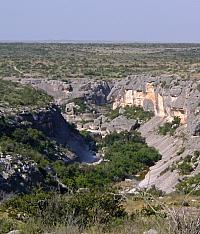
The cave paintings and the remarkably
well preserved cultural record of the Lower Pecos Canyonlands are
matched by few places on earth. White Shaman Cave contains
one of the most famous and celebrated pictographic panels
featuring a large anthropomorphic (human-like) figure
in white that is often interpreted as a shaman in the
midst of an otherworldly experience. Photo by Steve
Black.
Click images to enlarge
|
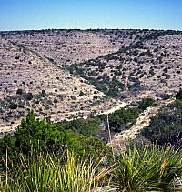
Oasis-like bands of green vegetation
along the canyon floors stand in contrast to the dry
rocky uplands. Different sets of plants and animals
can be found in both canyon and upland environments,
a fact that prehistoric peoples used to their advantage.
Photo from ANRA-NPS Archives at TARL. |
Sandals woven from the strong fibers
of desert plants can survive for thousands of years
in the dry cave deposits typical of the Lower Pecos Canyonlands. From the ANRA-NPS collections at TARL. |
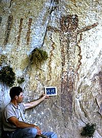
Although archeologists first visited
the Lower Pecos in the 1920s and 1930s, systematic work
did not begin until 1958. In this scene an archeologist
holds up a chalk board reading (in part) VL 18, a temporary
designation during the early phases of the survey work.
Photo from ANRA-NPS Archives at TARL. |
|
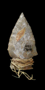
Archaic dart point with fiber bindings
still attached. From the ANRA-NPS collections at TARL. |
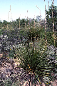
Sotol and other desert plants growing
in the uplands of the Lower Pecos Canyonlands were used in many
ways. Dried sotol flower stalks were used as firewood
and for tool-making, the thorn-lined fibrous leaves
were stripped and used to weave sandals, and the hearts
of the plant were baked for days and turned to sugary
carbohydrate. Photo by Steve Black. |
|