Devil's Sinkhole
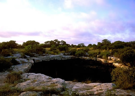
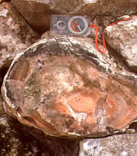
The name, Devil's Sinkhole, aptly connotes the dark depths and other-worldliness of a vast vertical chasm in the limestone bedrock on the far western reaches of the Edwards Plateau. Given it's unique qualities, the site was undoubtedly considered a sacred place by native peoples. Although there is no evidence of it within the cavern itself, several small prehistoric campsites, including a burned rock midden, ring the wide mouth of the sinkhole. Based on the single dart point recovered there - a Pandale type, with characteristic twisted body - the site was used by campers in the Middle Archaic period, sometime between 2500 to 4000 B.C. The sparse cultural remains and features, however, probably present an inaccurate picture of what may actually have occurred there in the prehistoric past. For years, cowboys and tourists collected artifacts and even stalactites from the cave interior.
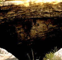
Located just north of Rock Springs in Edwards County near the headwaters of Hackberry Creek, the sinkhole is a vertical cavern cutting into Edwards Limestone with an opening measuring approximately 40 x 60 feet and a vertical drop to the main cavern of about 140 feet. The main cavern is circular and reaches a total depth of 350-400 feet. Part of a vast karst system of underground caves in the porous Edwards Plateau, the sinkhole was created when an underground solution cavity collapsed.
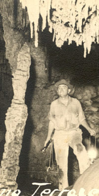
Native peoples found abundant, high quality chert for tool making at the site, one of the largest bedrock lithic resources in Texas. In much later times, the sinkhole was a gathering place for cowboys and cavers, who etched their names and other graffiti into the limestone walls. Beginning in the early 20th century, Edwards Plateau entrepreneurs began mining the sinkhole for bat guano to be processed into ammonia fertilizer.
While no professional archeological investigations have been conducted within the Devil's Sinkhole itself, archeological surveys of the area surrounding the chasm have identified a total of 21 prehistoric sites spanning late Paleoindian to Historic Period times. Based on the site sizes, the nature of the artifact assemblages, and the presence of burned rock middens on some sites, we know that prehistoric people used this landscape for short-term lithic procurement stations and long-term plant processing, tool manufacture and refurbishing, and habitation sites.
The presence of the burned rock middens, tell-tale evidence of the baking of such plants as sotol, which are present on the property today, indicates that these plants were among the area resources utilized by prehistoric inhabitants. The chipped stone artifacts recovered from the sites in the Devil's Sinkhole State Natural Area provide evidence of another resource that attracted prehistoric inhabitants to this area. All of the chipped stone tools, flakes and debris from these sites were produced from the same lithic material - Edwards chert. This fine-grained, good quality knapping material is abundant across the State Natural Area and beyond, and was extensively quarried by prehistoric inhabitants.
In addition to subsistence resources and lithic material, the sinkhole itself must have drawn prehistoric groups to the area. Evidence from other sinkhole sites on the Edwards Plateau and in the Lower Pecos regions of Texas indicate that these features were often used for burial of the dead, and they played integral roles in the sacred as well as the physical landscape of Native Americans. Native Americans often considered sinkholes, as well as caves, crevices, springs and seeps to be avenues to the underworld and the earth gods
Now part of a 1,859-acre preserve, the Devil's Sinkhole State Natural Area is open to visitors by appointment only. Access can be arranged by contacting the Devils Sinkhole Society at 830-683-2287. For more information see: www.tpwd.state.tx.us/spdest/findadest/parks/devils_sinkhole/
Credits and Sources
The Devil's Sinkhole exhibit was contributed by Tim Roberts, Texas Parks and Wildlife Department. Photographs also were provided by the agency, a partner of Texas Beyond History.
Heyden, Doris
1975 An Interpretation of the Cave Underneath the Pyramid of the Sun in Teotihuacan, Mexico. American Antiquity 40(2):131-147.
Howard, Margaret, Leigh A. Garcia, Carlos Beceiro, Dam K. Utley, Amy Ringstaff and Aina J. Dodge
1996 Archeological Survey of Devil's Sinkhole State Natural Area, Edwards County, Texas . Report prepared by the Cultural Resources Program, Texas Parks and Wildlife Department, Austin.
Marmaduke, William S., and Hayden Whitsett
1975 An Archaeological Reconnaissance in the Vicinity of the Devil's Sinkhole. In Devil's Sinkhole Area:Headwaters of the Nueces River, A Natural Area Survey , Part VIII of VIII, edited by Don Kennard, pp. 88-117. Division of Natural Resources and Environment, The University of Texas at Austin.
Vogt, Evon Z.
1976 Tortillas for the Gods: A Symbolic Analysis of Zinacanteco Rituals . Harvard University Press, Cambridge.