Ecoregions of Texas
Download lesson plan and included materials
Subject: Social Studies and Science
Grade: 7th
Author: Audra Roach, revised by Jason Terry and Mary Rodriguez (2023)
Time Duration: Two 50-minute class periods
Objective: Students will map the ecoregions in Texas and illustrate native vegetation. Students will use ecoregion maps to infer why prehistoric hunter-gatherers might have preferred to live in certain areas, such as the ancient Gault site north of Austin, Texas.
TEKS: Social Studies, Grade 7
- (2A), compare the cultures of American Indians in Texas prior to European colonization such as Gulf, Plains, Puebloan, and Southeastern
- (8A), locate and compare the Mountains and Basins, Great Plains, North Central Plains, and Coastal Plains regions
- (20A), differentiate between, locate, and use valid primary and secondary sources such as media and news services, biographies, interviews, and artifacts to acquire information about Texas
- (22A), use social studies terminology correctly
- (22C), create written, oral, and visual presentations of social studies information
Science, Grade 7
- (8B) analyze the effects of weathering, erosion, and deposition on the environment in ecoregions of Texas
Materials:
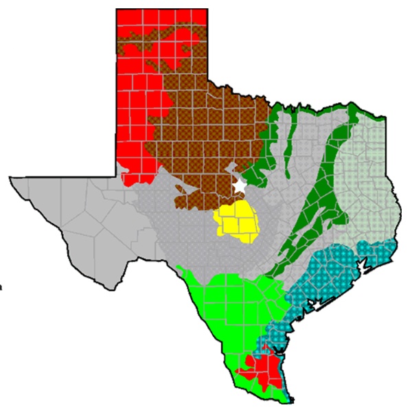
- Ecoregions of Texas Map (included)
- Ecoregions of Texas Student Activity Map (included)
- Internet access
- Assorted geographical and botanical reference materials (e.g. field guides to Texas, Texas maps, travel guides, nonfiction trade books)
Activities and Procedures:
Step 1: Engage students in a discussion of the different kinds of landscapes and vegetation that they have seen around the state of Texas. How do some parts of Texas look different from other parts? If you were a hunter-gatherer, which area would you choose to live in? Why? Introduce the term "ecoregion," or ecological region, which means the plants and animals of a particular area. Ecological regions are formed by different soil and climate, which in turn allow various plants and animals to live in the area.
Step 2: Present the "Ecoregions of Texas Map." Model how to learn about the plants in an ecoregion by using vegetation maps, and pictures of plants from the Internet and other reference materials. Good sites include:
- http://texastreeid.tamu.edu/content/texasEcoRegions/
- https://texashighways.com/wildflowers/the-wildflower-regions-and-vegetational-areas-of-texas/
Step 3: Ask students to choose one ecoregion to study in more depth with a partner. Using the Internet and other reference materials, student pairs should:
- Color Ecoregions of Texas Map and identify colors and/or patterns in the map key.
- Find and label the Gault site (Bell County, TX).
- Find and label 2 major cities in their chosen ecoregion.
- Illustrate and label 3 kinds of vegetation found in their chosen ecoregion.
Extension Activities: Create an educational bulletin board for the classroom or hallway that illustrates Texas ecoregions. Create a large Texas Ecoregions Map on butcher paper. Have students illustrate and label vegetation in the ecoregions and decorate with pressed leaves.
Closure: Have student pairs share their ecoregion vegetation information with the class. Ask students to speculate on why hunter-gatherers in Central Texas were attracted to the Gault site.