Dona Ana County Airport Site:
An Early Historic Native Campsite
The period between the demise of the Pueblo settlements around A.D. 1450 and the Pueblo Revolt of 1680 is one of the most poorly known archeological periods in the Trans-Pecos. Although the period is well-documented historically, the records are often ambiguous and confusing, and frequently contrast with what little archeological evidence there is. The Dona Ana County Airport site is the only well-documented archeological site from this time period. Though it is fairly ephemeral, the site sheds some light on how the people of the Trans-Pecos lived immediately before and after contact with the Spanish.
Like those in much of the southern part of the American Southwest, the Pueblo settlements of the Trans-Pecos were abandoned around A.D. 1450. This may have been the result of the demise of the influential Casas Grandes regional system of northern Chihuahua, or of an extended period of drought coupled with heavy reliance on an over-specialized agricultural economy. But the region was not completely abandoned. The people who remained reverted to a less intensive mobile adaptation that had closer affinities with the adaptations of the Archaic period than with those of the preceding Formative period. That is, they returned to a lifeway heavily dependent on hunting game and gathering wild plant foods.
The Dona Ana County Airport site is located in southeastern Dona Ana County, New Mexico, just west of the El Paso city limits, along the upper terrace of the Rio Grande. It is in an area once inhabited by the people whom the Spanish referred to as the Manso. They were so named, because their first words to the Spanish were "manxo, manxo, micos, micos," which meant "peaceful ones" and "friends.” The Manso lived in small communities, or rancherías, along the Rio Grande in the immediate area of El Paso, north to Las Cruces. They wore little, if any, clothing and decorated their bodies with paint. Men usually wore their hair short and dyed it red. They frequently carried bows, arrows, and clubs.
The site was discovered in 1983 by the Office of Contract Archeology, University of New Mexico, during a survey of a proposed airport facility. Surface collection and limited excavation of the site were conducted soon afterwards by the Cultural Resources Management Division (CRMD) of New Mexico State University under the direction of archeologist David Batcho. The data collected from the site was reanalyzed by archeologist Myles Miller in the mid-1990s.
The only features identified at the Dona Ana County Airport site were 17 burned rock and caliche hearths. Unfortunately, there is no site map illustrating the actual locations and relationships of the hearths. The question of whether there were habitation structures was also not resolved, because subsurface excavation was limited to hearth features. Spanish accounts suggest that the Manso slept outside on beds of grass, or in ephemeral structures consisting of straw, brush, or poles. Little evidence of structures like these would have been preserved at the site. However, Spanish accounts fail to consider that the Manso settlements they encountered may have only been the temporary camps of groups who were fleeing from them, and that the structures they described may have been much more ephemeral than was typical for the Manso.
The Dona Ana County Airport site produced no faunal remains and only one identifiable floral specimen. This specimen was originally identified as a kernel of corn, but Miller later found that it had been misidentified, and was actually a grass seed. Spanish accounts of Manso subsistence suggest that they did not practice agriculture, but had an economy that was based on hunting, gathering, and fishing. The Spanish observed the Manso eating horses and mules stolen from them, as well as rats, rabbits, fish, mesquite beans, prickly pear, agave, yucca, mescal, and unspecified roots and seeds.
A total of 230 chipped-stone artifacts was recovered from the site. Nearly 64% were made of obsidian and the rest of fine-grained chert and chalcedony. This percentage of obsidian is unusually high for the Trans-Pecos, where obsidian rarely exceeds 10% of a lithic assemblage, even at sites directly adjacent to obsidian-bearing gravel deposits. The site�s inhabitants transported obsidian nodules to the site from distant sources in northern Chihuahua and southwestern New Mexico, rather than obtaining them from the obsidian-bearing gravel deposits of the adjacent Rio Grande valley. The amount and types of chipped-stone debris indicates that knappers conducted all of their lithic reduction and toolmaking at the site. This pattern of lithic procurement and reduction indicates that the site�s inhabitants had a large territorial range and high degree of mobility that more closely resembles adaptations of the Archaic period than adaptations of the preceding Formative period.
The most common stone artifacts recovered from the Dona Ana County Airport site are cortical (exterior) flakes, small exhausted cores and core fragments, bipolar-flaked obsidian and chert nodules, and non-diagnostic shatter. The site�s tools include informal flake tools, bifaces, unifaces, hammerstones, battered cobbles, four projectile points, and one preform. The points could not be typed, but two of them are heavily reworked Archaic dart points and the other two are arrow points that are worked in a way that is similar to that of arrow points from historic mission contexts. Groundstone artifacts from the site include six metate and three mano fragments. They are all made of materials that are locally available in the secondary gravel deposits of the Rio Grande valley.
Only 17 ceramic sherds were recovered from the Dona Ana County Airport site. Four of them have been identified as Ramos Polychrome and seven as El Paso Polychrome. The remaining six are sand-tempered brownware sherds that have affinities with Spanish Colonial brownwares, but are more coarsely finished and poorly fired. They particularly resemble brownware sherds recovered from Nuestra Se�ora de Guadalupe de los Mansos at Paso del Norte, a Manso mission in El Paso. The only other artifact recovered from the site is a silver Spanish rowel. The rowel indicates that the site�s inhabitants had some contact with the Spanish and that they had adopted certain technological items associated with horse culture, but it is not known whether they actually possessed horses obtained or stolen from the Spanish or were using these items for some other purpose.
The presence of the Spanish rowel, along with the few radiocarbon dates obtained from the site, obsidian hydration analysis of the lithic artifacts, and typology of the arrow points and ceramics, dates the Dona Ana County Airport site to between A.D. 1565 and 1680. This makes it the only well-documented site from the Early Historic period. Though it does not reveal much detail about how people of this period lived, it does indicate that they were highly mobile foragers who lived much more like people of the Archaic period than like their recent ancestors.
Contributed by Carly Whelan based on a report by Myles Miller and other sources cited below.
Sources
Kenmotsu, Nancy A.
1994 Helping Each Other Out, A Study of the Mutualistic Relations of Small Scale Foragers and Cultivators in La Junta de los Rios Region, Texas and Mexico. Unpublished Ph.D. dissertation, Department of Anthropology, University of Texas, Austin.
Miller, Myles R.
2001 Post-Pueblo, Protohistoric, and Early Mission Period Archeology in Western Trans-Pecos Texas and South Central New Mexico, A.D. 1450-1680. Bulletin of the Texas Archeological Society 72:105-163.
![]() Download article as pdf file.
Download article as pdf file.
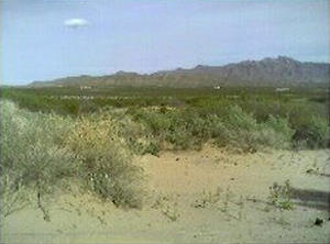
The Dona Ana County Airport site is located in southeastern Dona Ana County, New Mexico, just west of the El Paso city limits. It is the only well-documented archeological site in the Trans-Pecos from the poorly understood period between the demise of the Pueblo settlements around A.D. 1450 and the Pueblo Revolt of 1680. Photo by Leah Johnson.
|

Artist's depiction of a Manso hunter with characteristic red-dyed hair. The Dona Ana County Airport site lies in an area historically associated with the Manso. There was no evidence at the site, however, that helps assign ethnic affiliation to the site's inhabitants. Photo of display at the El Paso Museum of Archaeology. |
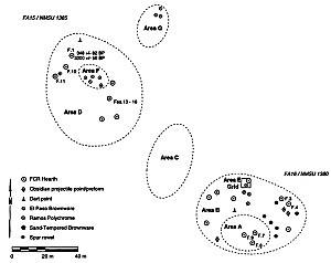
Sitemap of the Dona Ana County Airport site showing the locations of its artifacts and features. This sitemap was reconstructed by Myles Miller during his analysis of the site in the mid-1990s, because the original sitemap was lost. Graphic from Miller 2001, Fig. 8.
|
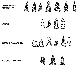
Typical projectile points for the Late Formative and Spanish Colonial periods in the El Paso area, contrasted with two specimens from the Dona Ana County Airport site; first row: projectile points recovered from Late Formative period pueblo and pithouse settlements in the El Paso area; second row: projectile points recovered from the Dona Ana County Airport site; third row: projectile points recovered from the Ysleta WIC site (A.D. 1680-1725); fourth row: projectile points recovered from two late 18th through mid-19th century sites in the area of Ysleta. Graphic from Miller 2001, Fig. 11. |
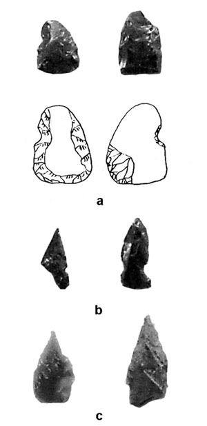
Select formal tools from the Dona Ana County Airport site; a: obsidian preform and uniface with drawings of preform; b: obsidian projectile points; c: Archaic dart point, extensively reworked projectile point, and unifacial tool. Nearly 64% of the site’s chipped-stone artifact assemblage is made of obsidian. This is unusually high for the Trans-Pecos, where obsidian rarely exceeds 10% of a lithic assemblage, even at sites directly adjacent to obsidian-bearing gravel deposits. Photo from Miller 2001, Fig. 10.
|

A silver Spanish rowel similar to this one was recovered at the site, indicating that its inhabitants had contact with the Spanish. |