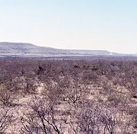
Musk Hog Canyon
Small foraging groups gathered and cooked desert plants in the arid environment of Musk Hog Canyon in the final thousand years or so of the prehistoric era. Located in western Crockett County, the canyon drains runoff from adjacent parts of the western Edwards Plateau into the Pecos River. While no single archeological site in the canyon yielded an exceptional record of prehistoric occupation, the combined evidence from the large number of sites surveyed in Musk Hog Canyon provided archeologists with the rare opportunity to examine site relationships on a fairly large level.
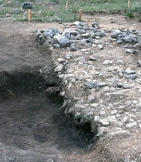
Archeological investigations at Musk Hog Canyon were initiated by the Texas Department of Transportation (TXDOT) in 1971 in advance of the construction of IH-10. Over the next six years, both TXDOT and the Texas Archeological Society (TAS) conducted survey and excavation in the area. During their annual field school in 1976, survey crews from the TAS recorded 435 archeological sites in the canyon. In all, 546 sites in the canyon were discovered and recorded from 1971 through 1977. Although several rock shelters were discovered in the canyon, investigators generally encountered the remains of small, prehistoric campsites dating from the last part of the Late Archaic through historic times (ca. A.D. 600-1800).
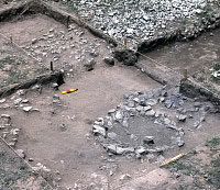
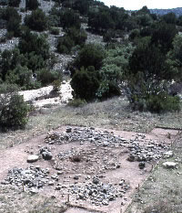
Occupations at all Musk Hog Canyon sites were characterized by artifacts and features related to plant processing and cooking, including hearths, burned rock middens, bedrock mortars and manos and metates. Artifacts believed to reflect a hunting lifestyle, such as projectile points and hide scrapers, were less common at sites in the canyon than at sites on the eastern portions of the Edwards Plateau. These artifacts and features, combined with limited plant remains recovered from rock shelters in the canyon, led archeologists to believe that prehistoric subsistence in the region was focused on the intensive exploitation of plant resources.
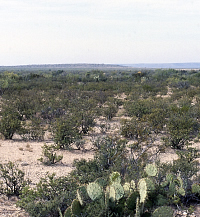
Musk Hog Canyon lies in an area that today receives an average of between 14 and 18 inches of rainfall a year. In comparison, parts of the eastern portion of the Edwards Plateau receive almost twice as much rainfall in a year. By all indications, the climate found today in the area around Musk Hog Canyon is much the same as it was in prehistoric times. Since such low levels of rainfall cannot support the plant life that larger animals, such as white-tailed deer and buffalo, need to survive in great numbers, archeologists have typically believed that prehistoric groups in the region often turned to desert plants such as sotol and lechuguilla to survive. Yet while features such as burned rock middens and bedrock mortars are certainly some of the most noticeable components of archeological sites in Musk Hog Canyon, their visibility can lead to the erroneous conclusion that prehistoric peoples inhabiting the region relied heavily on plants for food. In fact, the area around Musk Hog Canyon is home to numerous squirrels, rabbits, deer, and snakes, the bones of many of which have been preserved in other archeological sites in the region. Further, many of these animals could have been hunted with perishable implements such as nets that did not require the use of dart or arrow tipped projectiles, leaving little evidence of their use in the archeological record.
The large number of sites in Musk Hog Canyon yielding similar archeological remains seems to indicate that lifeways in the area changed little from the Late Archaic into historic times. While desert plants such as sotol and lechuguilla were almost certainly dietary components of prehistoric peoples in the canyon, preservational bias may distort the degree to which plants were favored over animals.
Luke, Clive J.
1983 Continuing Archaeology on Interstate Highway
10: The Musk Hog Canyon Project, Crockett County, Texas .
Texas State Department of Highways and Public Transportation Highway
Design Division, Publications in Archaeology Report No. 24, Austin.
Moore, William E.
1983 Archeological Investigations at Musk Hog Canyon,
Crockett County, Texas : A Report of the 1976 Texas Archeological Society
Field School. Bulletin of the Texas Archeological Society 53:13-82.