Cabeza de Vaca Meets the Coahuiltecans
Subject: Social Studies and Art
Grade: 4th and 7th
Author: Carol Schlenk, revised by Jason Terry (2023)
Time Duration: Two 45-minute class periods or one 90-minute block period
Overview: This lesson will give students experience using historic documents while they learn about Texas' first non-native visitor (Cabeza de Vaca) and his journey among native peoples, including the Coahuiltecans. Students will learn to distinguish the difference between primary sources, such as Cabeza de Vaca's journal, La Relación (The Account), and secondary sources, such as their history books or the posters they will create in this lesson.
Objective: Students will create a poster portraying the cultures of Coahuiltecan Indian groups in south Texas during the 16th century, based on the journal of Cabeza de Vaca. Students will work in cooperative groups to:
- Label and color a Texas map with the South Texas Plains region of Texas that was home to many different Coahuiltecan Indian groups.
- Research Coahuiltecan Indian groups.
- Read excerpts from Cabeza de Vaca’s 1538 journal, La Relación, a primary source document.
- Illustrate cultural aspects of some of the Coahuiltecan groups gleaned from Cabeza de Vaca’s journal.
- Combine all work to create posters/digital products (secondary source documents).
TEKS: Social Studies, 4th Grade
- (1B), identify and compare the ways of life of American Indian groups in Texas before European exploration such as the Lipan Apache, Karankawa, Caddo, and Jumano
- (1C), describe the cultural regions in which American Indians lived such as Gulf, Plains, Puebloan, and Southeastern
- (2B), identify the accomplishments and explain the impact of significant explorers, including Cabeza de Vaca; Francisco Coronado; and René Robert Cavelier, Sieur de la Salle, on the settlement of Texas
- (6A), identify, locate, and describe the physical regions of Texas (Mountains and Basins, Great Plains, North Central Plains, Coastal Plains), including their characteristics such as landforms, climate, vegetation, and economic activities
- (7A), explain the geographic factors such as landforms and climate that influence patterns of settlement and the distribution of population in Texas, past and present
- (8B), explain reasons why people have adapted to and modified their environment in Texas, past and present, such as the use of natural resources to meet basic needs, facilitate transportation, and enhance recreational activities
- (9A), explain the economic activities various early American Indian groups in Texas used to meet their needs and wants such as farming, trading, and hunting
- (19A), differentiate between, locate, and use valid primary and secondary sources such as technology; interviews; biographies; oral, print, and visual material; documents; and artifacts to acquire information about Texas
- (21D), create written and visual material such as journal entries, reports, graphic organizers, outlines, and bibliographies
- (1A), identify the major eras in Texas history, describe their defining characteristics, and explain the purpose of dividing the past into eras, including Natural Texas and its People; Age of Contact
- (2A), compare the cultures of American Indians in Texas prior to European colonization such as Gulf, Plains, Puebloan, and Southeastern
- (2B), identify important individuals, events, and issues related to European exploration of Texas such as Alonso Álvarez de Pineda, Álvar Núñez Cabeza de Vaca, the search for gold, and the conflicting territorial claims between France and Spain
- (9A), identify ways in which Texans have adapted to and modified the environment and explain the positive and negative consequences of the modifications
- (20A), differentiate between, locate, and use valid primary and secondary sources such as media and news services, biographies, interviews, and artifacts to acquire information about Texas
- (22C), create written, oral, and visual presentations of social studies information
- (2C), produce drawings; paintings; prints; sculpture, including modeled forms; and other art forms such as ceramics, fiber art, constructions, mixed media, installation art, digital art and media, and photographic imagery using a variety of art media and materials
- (3D), investigate connections of visual art concepts to other disciplines
- (1A), identify and illustrate ideas from direct observation, original sources, imagination, personal experiences, and communities such as family, school, cultural, local, regional, national, and international
- (2A) create original artworks that express a variety of ideas based on direct observations, original sources, and personal experiences, including memory, identity, imagination, and the community
- (2C) apply technical skills effectively using a variety of materials to produce artworks, including drawings, paintings, prints, sculptures/modeled forms, ceramics, fiber art, photographic imagery, and digital art and media
Materials:
- Texas history textbooks or access to the internet
- Texas map student handout (included)
- La Relación readings student handouts (included)
- Coahuiltecan Note Taking Sheet (included)
- poster board (instead of poster, student product may be completed digitally using Google Slides or another platform)
- drawing and coloring materials
- scissors
- glue
- Internet access for Who Were the "Coahuiltecans"?: https://www.texasbeyondhistory.net/st-plains/peoples/coahuiltecans.html
Activities and Procedures:
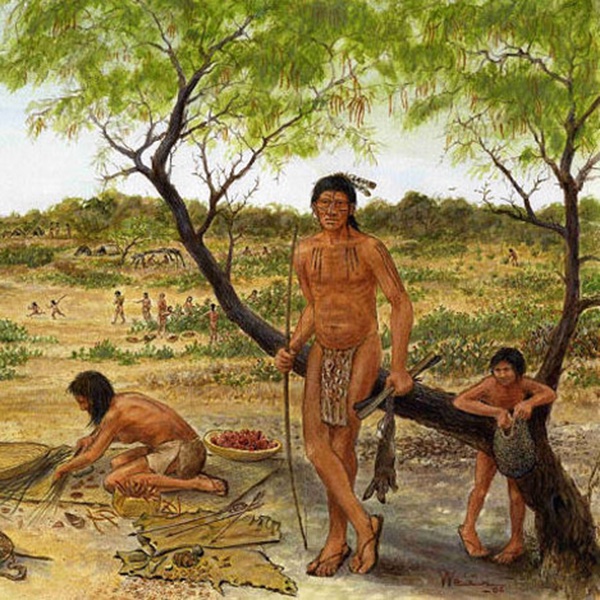
Step 1: Display the painting of a Coahuiltecan campsite from the Texas Beyond History website linked below. Have students make 2-3 inferences about Coahuiltecan culture/lifestyle as an opening to the lesson: https://www.texasbeyondhistory.net/st-plains/peoples/coahuiltecans.html
Step 2: Introduce Cabeza de Vaca as the Spanish explorer who came to America from Spain in 1527 and wandered, lost, across what is now Texas and Mexico for nine years before returning to his native Spain. Explain that during his Texas travels, Cabeza de Vaca encountered several different groups of Indians. We use the geographic term Coahuiltecans to describe these native groups because they lived in the region that is now part of Coahuila, Mexico, as well as south Texas. Some of the native groups, however, had different traditions, spoke different languages, and had different names for themselves. Explain that students will work in cooperative groups to create posters illustrating Cabeza de Vaca’s experiences among the Coahuiltecans.
Step 3: Have students do some basic research on the Coahuiltecan Indian groups using textbooks, library books, or the internet. Have them record their answers on paper or on the graphic organizer (Coahuiltecan Note Taking Sheet) provided. Some useful websites include:
- Texas Beyond History’s illustrated look at various Coahuiltecan groups of the South Texas Plains: http://www.TexasBeyondHistory.net/st-plains/peoples/coahuiltecans.html
- https://www.tshaonline.org/handbook/entries/coahuiltecan-indians
Step 4: Distribute the Texas map student handout to all students and explain that in their groups, only one group member’s map will be used on that group’s poster (the students will choose which map – see step 6). Using information from their textbooks or the internet, have students label their maps with the following:
- map title – Coahuiltecans of the South Texas Plains
- Rio Grande
- Coahuiltecan habitat (labeled, outlined, and colored on their maps
- compass rose
Step 5: Have students get into groups of 3 or 4.
Step 6: Ask for a volunteer to describe the difference between primary and secondary source documents. Explain that after Cabeza de Vaca finally returned to Spain, he wrote of his American travels in a book called La Relación, which was published in 1538. Ask students whether this book is a primary or secondary source document. Point out these readings were translated by a scholar and that all translations of this journal differ slightly.
Step 7: Explain that each group will illustrate 5 sections of Cabeza de Vaca’s journal for their posters. These posters will be secondary source documents. (Note: for 4th grade, you may want to give each group only 1 or 2 primary sources to focus on depending on student ability.)
Step 8: Distribute one poster board to each group. Instruct groups to decide which of their group member’s maps they want to include on their poster and glue it on their posterboard.
Step 9: Distribute La Relación readings to each group and have group members choose which one they want to illustrate. The illustration can be drawn directly on the poster, or on paper, which can then be glued to the poster. Completed posters should contain:
- An appropriate title for each reading
- A map of the Coahuiltecan Indian groups’ range
- The La Relación readings
- Illustrations of each reading
Step 10: Have a representative from each group present that group’s poster to the class and ask the following questions of each?
- How did your group choose what to illustrate from your readings?
- In historic terms, what was the most significant part of your reading? Explain why.
- How did your group’s initial research of the Coahuiltecan Indian groups compare to Cabeza de Vaca’s accounts of them?
Student Product: Research information on the Coahuiltecan Indian groups and illustrated poster of Cabeza de Vaca’s experience among the Coahuiltecan Indians groups including a map of their range in Texas.
Closure: Have students list three things they would miss most about their current lives if they were stranded in a strange country for nine years.
Extension Activities:
For fun, colorful, and bilingual online activities dealing with Cabeza de Vaca’s experience in Texas, be sure to go to Through the Eyes of the Explorer: Cabeza de Vaca on the South Texas Plains http://www.texasbeyondhistory.net/st-plains/kids/cabeza-south/cdv_mainpage.html
The full text of Cabeza de Vaca’s journal, La Relación, can be viewed at: https://exhibits.library.txstate.edu/cabeza/
Assessment: Ask students how Cabeza de Vaca’s experience would have differed had he been stranded in the East Texas Piney Woods, the Panhandle, or the Trans-Pecos regions of Texas.