Texas Beyond History
TBH Home
Frontier Forts Main

Trails of the Trans-Pecos

wagon trail in the Davis Mountains
A wagon train of emigrants headed for California enters a narrow passage of the Davis Mountains. The scene, "Entrance to Wild Rose Pass," was painted by U.S. Army Capt. Arthur T. Lee in the mid- to late 1850s during his tour of duty in the Trans-Pecos. Image courtesy of the Rochester Historical Society.
Trans Pecos
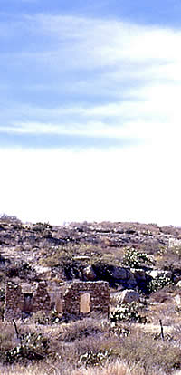
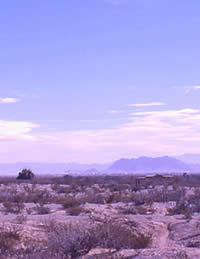
The dusty, flat landscape of the Trans-Pecos is broken abruptly by mountains such as the Chisos, Chinati, Glass, and Davis rising high above the desert floor. This scene is in Presidio County, near the Rio Grande. TARL Archives.
Jumano Indians
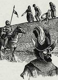
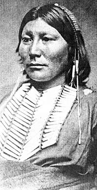
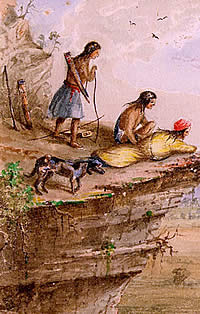
Jumano Indians standing atop the walls of their pueblo watch the arrival of Spanish explorers. According to explorer Hernán Gallegos, who traveled the Trans-Pecos near La Junta in 1581, the early farmers greeted them with "great merriment." Drawing by Hal Story (Newcomb 1961).
La Junta de Los Rios
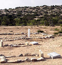
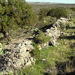
Scene near La Junta de Los Rios, Presidio County, Texas. Photo from TARL Archives (Presidio C-15).
antelope
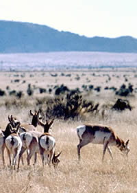
Pronghorn grazing in grasslands in far West Texas. Photo courtesy Texas Parks and Wildlife.
Comanche Lookout
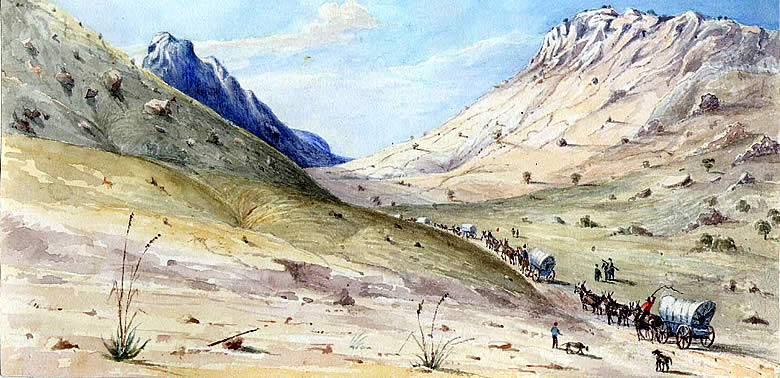
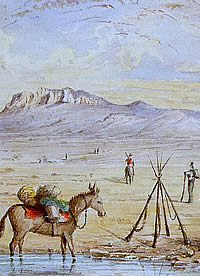
From a high overlook, Indians keep a watchful eye on a caravan of travelers trudging through a Trans-Pecos basin in far west Texas. "Comanche Lookout" was painted in the mid- to late 1850s by Capt. Arthur T. Lee, who was captivated by the aboriginal peoples and stunning scenery near Fort Davis. Image courtesy of the Rochester Historical Society.
Comanche trails map
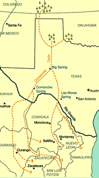
Routes of Comanche trails from villages on the Plains. Adapted from Weber 1982.
Peocs River
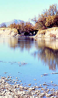
Pecos River crossing near Fort Lancaster. Photo by Susan Dial.
Ft. Bliss
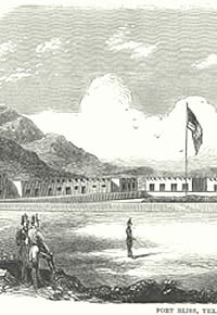
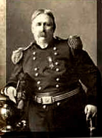
Fort Bliss, Texas. Established as a camp in 1849, it was relocated to its present position in what is now El Paso.
Trans Pecos after 1855
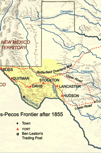
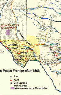
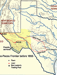
The Trans-Pecos frontier after 1855 and prior to the Civil War.

Much of the history of the Trans-Pecos region of southwestern Texas has been of peoples on their way to some place else. The Spanish mostly went around it. Comanche and Kiowa raiders rode through it from the north on their way to Mexico. Anglo-Americans came from the east, headed for the California gold fields and western cattle markets. In time, the travelers and their trails drew the attention of the United States Army.

Prehistoric peoples lived and traded along the middle Rio Grande—named El Rio del Norte by the Spanish—for thousands of years before the arrival of Europeans. In 1535, the wandering Alvar Nunez Cabeza de Vaca found Jumano and other native groups farming the land at the junction of the Rio Grande and the Rio Conchos—la junta de los rios—opposite the site of modern Presidio, Texas.

Two Spanish exploratory expeditions in the early 1580s came down the Conchos, passed through la junta, turned northwest, and followed the Norte toward its upper reaches. In 1598, Juan de Oñate was authorized to settle the lands within the modern boundaries of New Mexico. He traveled over the Chihuahuan plateau to reach the Rio Grande some 150 miles upstream from la junta, and memorialized his crossing of the river as El Paso del Rio del Norte. He then followed the river to the pueblos of the north, where he settled his colonists and established the town of Santa Fe.

Oñate found the Puebloans trading with Plains Indians who brought buffalo robes to exchange for corn and other agricultural products. The outlanders—the Spanish called them vaqueros because of their trade in "cow" hides—were the Plains Apache. The center of this trade was the Pecos Pueblo, across the mountains to the east of Santa Fe and near the headwaters of the Pecos River.

The province of Nuevo Mexico grew steadily, if somewhat slowly, but the harshness of a succession of Spanish governors led to an Indian revolt in 1680. The Spaniards withdrew to the south and took refuge near Oñate's crossing of the Rio Grande. Their northward advance stymied, the Spanish began to dig in along the middle stretch of the river and to establish missions at the Paso del Norte and la junta. These missions remained after the Spanish returned to Santa Fe. In 1760, the Spanish would establish Presidio de la junta de los Rios Norte y los Conchos—known more simply in later years as Presidio del Norte—to protect the missions at the junction of the Rio Grande and Rio Conchos.

The missionary efforts at la junta were plagued by Spanish slavers who captured local Indians and carried them south to work in the silver mines. Apaches who visited the Puebloans of New Mexico likewise were periodically abducted by the Spanish and transported to the interior of Mexico. When Comanches began to intrude on the Apache range in the early 1700s, they attacked the pueblos and the nearby New Mexican settlements. In desperation, the Spanish government in 1786 made an alliance with the Comanches in which they combined to make war against the Apaches. In addition to other terms, the Spanish New Mexicans offered the Comanches a horse and bridle and two knives for each Apache captive brought to Santa Fe.

Throughout the remainder of the Spanish colonial period and 25-year interval of Mexican rule, the settlers of New Mexico were able to maintain relatively peaceful trade relations with the Comanche. But that peace was maintained at a tremendous cost that was paid by settlers in the northern Mexico provinces of Chihuahua, Coahuila, Durango, and Zacatecas. As the Apache lost control of the Plains and scattered into the mountains of Mexico and the Trans-Pecos, the Comanche began to raid the Mexican settlements south of the Rio Grande. Captive Mexicans would be carried north, and some would be brought to the New Mexico settlements to be ransomed.

The Comanche Trail from the High Plains into Mexico—sometimes called the "Comanche War Trail" or the "Comanche Trace"—is shrouded in legend and mystery. It appears not to have been one trail, but several that converged somewhere on the Plains or in the Trans-Pecos, passed by the prodigious springs at the present city of Fort Stockton, and diverged again to cross the Rio Grande at multiple points. Raiders following the upriver, or western, trails could strike at Chihuahua and Durango; those following the eastern branches could attack Coahuila and Zacatecas.

The Mexicans' successful revolution against Spanish rule opened a new era of international trade along the famous Santa Fe Trail, which ran from Independence, Missouri, into northern New Mexico. From Santa Fe, the trade extended south through the Paso del Norte, and on to Chihuahua City. When the United States and Mexico went to war in 1846, one of the U.S. Army's invasion routes into Mexico followed the Santa Fe-Chihuahua Trail.

After three years of war, the United States in 1848 obtained the land west of the new state of Texas—the territory comprising the modern states of New Mexico, Arizona, and California. As word of discovery of gold in California began to reach the east, exploratory expeditions and immigrant parties began to enter the Trans-Pecos in search of a viable route to the Pacific. Texas rangers John C. Hays and Samuel Highsmith attempted to map such a road, but became hopelessly lost. They probably were saved only by fortuitously stumbling upon a trading post known as Fort Leaton.

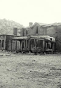
Chihuahua Trail freighter Ben Leaton had purchased property near la junta in 1848. He expanded upon existing structures to establish a home, trading post, and private fort. The Hays-Highsmith party recuperated at Leaton's place for 10 days before leaving for San Antonio, which they reached in December, 1848, and where they reported that they had found a practicable wagon route from San Antonio to the Presidio del Norte.

Within two months after the return of the Hays-Highsmith party, U.S. Army lieutenants W.H.C. Whiting and William F. Smith departed San Antonio with orders to try to find a viable route west, using the dubious Hays-Highsmith experience to reach the Rio Grande at Presidio del Norte. The expedition first headed northwest, passing through the German settlement at Fredericksburg before reaching the San Saba River. It followed the San Saba to its headwaters, then headed west beyond the Pecos River and south to Fort Leaton.

The Whiting-Smith party followed the Rio Grande northwest to the Paso del Norte, but decided to return on a more direct route that bypassed Fort Leaton and reached San Antonio by way of the Devil's River, Las Moras Springs, the Nueces River, and the Alsatian village of Castroville. Fort Leaton, believed to be the largest adobe structure in Texas, would eventually fade into obscurity. Ben Leaton died in 1851, but not before Mexican authorities accused him of selling guns to Comanches in return for stolen horses.

By mid-1849, the army had plotted the wagon road that became known variously as the "government," "lower," or "southern" road west from San Antonio. In September, Captain Jefferson Van Horne and four companies of the 3rd Infantry traveled through the Trans-Pecos and established a camp at the ranch of Benjamin Franklin Coons, across the river from the Mexican town that had become known, simply, as "El Paso." The army's post would be abandoned, relocated, and ultimately named Fort Bliss. The Anglo town that grew up across the river from Mexican El Paso would be known as "Franklin."

In the meantime, the army's and the public's desire for means of transcontinental communication and commerce was recognized by Henry Skillman, a veteran trader on the Santa Fe-Chihuahua Trail. In 1851 he was awarded a contract for U.S. mail service from San Antonio to Santa Fe via Franklin. By December, Skillman was offering passenger service.

Skillman formed a partnership with George Giddings in 1854, and the two attempted to put the operation on a stronger financial footing. But the business would always be endangered by Lipan Apaches on the eastern end of the route, Mescalero Apaches in the mountains of the far western Trans-Pecos, and Comanches and Kiowas in between. In less than two years, the Giddings-Skillman operation lost more than $54,000 worth of livestock, wagons, and buildings to Indian attacks.

Two U. S. Army posts guarded the gateways from the interior of Texas into the Trans-Pecos. Fort McKavett, near the headwaters of the San Saba River, protected the "upper" road through Fredericksburg . Fort Clark, near the Rio Grande, protected the "lower" road through Castroville. But a similar military presence was needed farther west, and in 1854 the army established a post near Limpia Creek in the mountains of the Trans-Pecos. It was named Fort Davis, after United States secretary of war Jefferson Davis. The following 
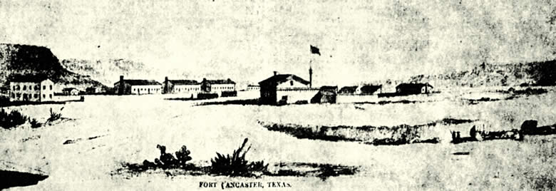
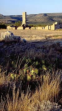
year, Fort Lancaster was established on Live Oak Creek near its confluence with the Pecos River.

wildflowers
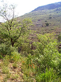
Wildflowers in the Davis Mountains. The lush vegetation in the mountains of the Trans-Pecos provides a stark and welcome contrast to the Chihuahua desert. Photo by Susan Dial.

Click images to enlarge

artifacts
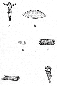
Traces of different cultures: artifacts from the Polvo Site, located downstream from the confluence of the Rio Grande and Río Conchos—La Junta de los Ríos. The area was inhabited by Patarabueye/Jumano Indians from about 1200 to 1400 and later by Spaniards and Mexicans. Drawing from Cloud et al., 1994, courtesy of the Texas Historic Commission. Click for more detail.

The missionary efforts at La Junta were plagued by Spanish slavers who captured local Indians and carried them south to work in the silver mines.

ruins of Leaton's trading post
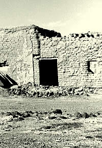
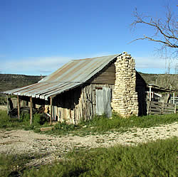
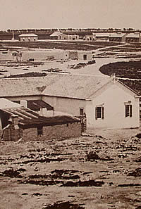
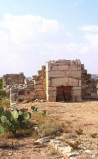
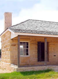
Ruins of freighter Ben Leaton's trading post, established near La Junta in the 1840s. Called Fort Leaton, it was not an army post but a family fortress and trading post, providing shelter and sustenance to travelers between Eagle Pass and El Paso. The adobe compound has now been restored by Texas Parks and Wildlife. Photo, TARL Archives.
Far west Texas
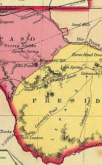
Far west Texas, showing Presidio del Norte and confluence of the Rio Grande and Rio Conchos. Lt. Smith's and Whiting's road and Connelly's routecrosses the Comanche trail near Comanche Springs. Slightly to the northeast is Horsehead Crossing, the flat, shallow ford where hundreds of wagons crossed the Pecos River. Inset of map by G. W. Colton, 1856, courtesy of the David Rumsey Map Collection. Click to enlarge.
emigrants crossing the Pecos
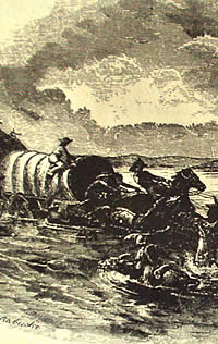
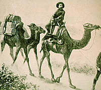
Emigrants bound for California crossing the Pecos River at Horsehead Crossing, west Texas, circa 1850.
Trans Pecos before 1855
Emigrant routes across the vast open spaces of the Trans-Pecos frontier are clearly shown in this map.
old stagecoach road
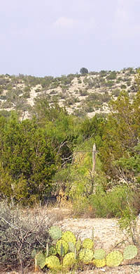
Traces of the old stagecoach road from San Antonio to El Paso are dimly visible as a light vertical streak descending from a gap in the hills above Fort Lancaster. The ride over stony hills was treacherous enough; stops along the way, amid cactus and mesquite scrub, was often worse. As one 1850s traveler wrote 
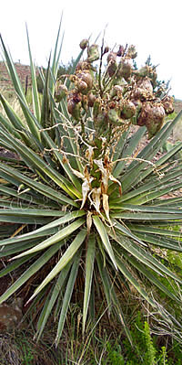
of the Trans-Pecos: "One of the most remarkable features of this inhospitable region is the hostility with which every plant bears arms… ." Photo by Susan Dial.
Road from Ft. Clark to Ft. Stockton
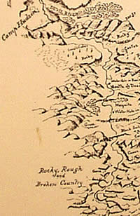
"Rocky, rough and broken country…." Inset of Topographical Sketch of the Road from Fort Clark to Fort Stockton, 266 miles, October to November, 1867; and camps of Bvt. Lt. Col. A. J. Strong. Camp Hudson is shown at top, midway between Forts Clark and Davis. Courtesy Fort Stockton Historical Museum.
Ft. Lancaster
Fort Lancaster, circa 1861, as sketched by a government draftsman. The fort was strategically placed to protect the San Antonio to El Paso mail route—the Lower Road—and the thousands of emigrants passing through en route to California. In its heyday, the fort had more than 20 buildings. Lancaster has the distinction of being the only post in Texas to be attacked by Indians. Read the 1867 report of attack. Courtesy Fort Lancaster SHS.
Ft. Lancaster
Morning light reflects off the limestone ruins of Fort Lancaster in Crockett County. The post housed only infantry companies made up largely of Irish and German immigrants; average size of the garrison in the 1850s was about 140 men. Photo courtesy of Texas Parks and Wildlife Department.

In 1858, Fort Quitman was added on the Rio Grande, about 75 miles below Franklin. Fort Stockton was established in 1859 at the springs near the intersection of the Comanche Trail and the government road. The army also maintained a small post on the Devil's River, called Camp Hudson.

The lack of water and forage in the region prompted one of the more unusual innovations in the army's history—the use of camels for transportation. In 1855, the Congress appropriated $30,000 to import camels for military purposes. The first herd of 32 was sent to Camp Verde in the Hill Country west of San Antonio, and was followed by another group of 41. After a number of localized experiments, an expedition including 25 camels departed for New Mexico to participate in an exploration of the Colorado River near California.

Traffic through the Trans-Pecos began to increase in the late 1850s. In 1857 the U.S. Postmaster awarded a mail contract to the Butterfield Overland Mail Company for service from St. Louis, Missouri to San Francisco, California. James Birch had competed for the contract, and his consolation prize was a contract for service from San Antonio to San Diego, California, by way of El Paso. Birch soon formed a partnership with Giddings, and Skillman was hired to help set up the line. The first mail from San Antonio to the Pacific reached San Diego in August.

Cemetery at Ft. Lancaster
Cemetery at Fort Lancaster with graves of children who died at the post during the 1850s. The center grave is that of Arthur T. Lee, son of Capt Arthur Lee, the artist-soldier who painted scenes of his stay in the west, including the painting at the top of this page. Photo by Susan Dial.
camels
Camels trekking across the Trans- Pecos in the 1850s awed travelers and Indians. Because of their ability to withstand desert conditions, the animals were thought to be a perfect means of transport for army supplies.
stage stop Howard's well limestone wall
Howard's Well, a stage stop on the Southern Overland Mail route, was the target of repeated attacks by Indians throughout the 1850s and 1860s. The well—springs enclosed by limestone walls—was an important water source for travelers crossing the parched terrain. The jacal building shown above may date as early as the 1860s; a previous station on the site was destroyed by Comanches in 1861. At right is a limestone wall which may have been part of a corral. Photos by Claude Hudspeth, TARL Archives.
White Horse
White Horse. The Kiowa chief, along with Lone Wolf and Big Tree, led warriors in a violent attack on a wagon caravan at Howard's Well station in April, 1872. Army troops arriving on the scene shortly thereafter found the freighters' charred bodies lashed to wagon wheels and burned bodies of women and children strewn over the ground. Crimmins Collection, courtesy of the Center for American History, University of Texas at Austin.
Ft. Stockton
Fort Stockton, ca. 1884. The fort was established in 1859 near Comanche Springs, a major watering hole for Anglo and Indian travelers crossing the Chihuahuan desert. In its heyday, Stockton had eight officers quarters, five barracks (shown along the top, right), three stables and several other buildings. Photo courtesy Fort Stockton Historical Museum.
Ft. Stockton
Officers quarters at Fort Stockton front the dusty parade ground. The building on right has been restored by private owners. Photo by Susan Dial.
William Shafter
Ordered to clear the Indians from the region, legendary military leader William R. "Pecos Bill" Shafter and a combined force of Buffalo Soldiers, Seminole-Negro Indian scouts, and Tonkawa scouts patrolled the southern Llano Estacado and the eastern Trans- Pecos for four months in 1875, covering some 2,500 miles.

The route of the competing Butterfield line crossed northwestern Texas beyond Fort Worth and passed through Fort Belknap, Fort Phantom Hill, and Fort Chadbourne before reaching the Pecos River near the border with New Mexico. The route passed along the base of the Guadalupe Mountains on its way to Franklin. The portion of the route west of the Pecos was shifted south through Fort Stockton and Fort Davis in 1859. For the next two years, the Butterfield line and the Giddings line shared the government road through the Trans-Pecos to Franklin, which became the nucleus of the new Anglo town of El Paso.

The early 1860s brought a suspension of civilian travel in the Trans-Pecos. Texas seceded from the United States in February, 1861, and the Butterfield line abandoned its service through Texas the next month. The U.S. Army's Trans-Pecos forts were abandoned at the beginning of the Civil War. A column of California volunteer infantry reclaimed Fort Bliss for the United States in 1862, and Fort Quitman in 1863.

The association of black soldiers with the army's defense of Texas' southwestern frontier began in 1867 with the arrival of the 9th Cavalry at Fort Davis, Fort Stockton, and Camp Hudson. The Congress reserved two regular army cavalry regiments and four of infantry to be manned by black enlisted personnel and white officers. The mounted units were the 9th and 10th Cavalry; the foot soldiers comprised the 38th, 39th, 40th, and 41st Infantry. By the end of the 1860s, the four infantry regiments would be merged to form two—the 24th and 25th Infantry.

Fort Lancaster was used briefly after the Civil War as a 9th Cavalry sub-post. On the day after Christmas, 1867, a detachment of Company K was attacked there by a force estimated as numbering more than 900 Indians. The officer commanding the cavalry detachment reported that the attackers included a number of Spanish-speakers and English-speakers. One possible explanation is that the Indians were Comanches, the Spanish-speakers were New Mexican comancheros, and the English-speakers were former Confederate "renegades," as the army officer characterized them.

The comancheros were a later manifestation of the trade that had existed with the Comanches in the Pecos River valley of New Mexico since the mid-1700s. The Comanches had succeeded to the position of the Apaches as purveyors of buffalo robes to the Puebloan Indians and, later, Spanish New Mexicans. They would add stolen horses and—in a throwback to the former Spanish slave trade—captive Mexican and Anglo women and children to their inventory of trade goods.

In addition to reoccupying the abandoned forts, the army in 1867 established a new post near the junction of the main and north forks of the Concho River. Named Fort Concho, it was positioned to guard Goodnight-Loving cattle trail and the San Antonio-El Paso mail service on the "upper" road, as well as to interdict Indian raiders on their way from the Plains to the Texas Hill Country settlements and Mexican villages.

After the Civil War, Texas cattle became a commodity the Comanches valued for the New Mexico market, and the Goodnight-Loving Trail provided many targets of opportunity. Pioneered by Texas frontiersmen Charles Goodnight and Oliver Loving, the trail drives began in central north Texas west of Fort Worth, traveled southwest along the old Butterfield mail line to the Pecos River, then north along the river to Fort Sumner, in eastern New Mexico. Extensions of the trail continued north to Colorado and Wyoming. Comanches stole thousands—perhaps tens of thousands—of cattle from drovers along the trail in the late 1860s and early 1870s. The portion of the trail along the Texas stretch of the Pecos was hit especially hard.

Lieutenant Colonel William R. Shafter was ordered to clear the Indians from the region in 1875. Shafter's expedition lasted nearly four months, crossed the Llano Estacado three times, and covered some 2,500 miles. The campaign produced only three small skirmishes, but mapped territory that had previously been unknown to the army, and opened the area to the potential of white settlement. With that task completed, the army began to turn its attention to the western Trans-Pecos, where the last major Indian campaign in Texas would be fought.

In 1877, the Warm Springs Apache leader Victorio broke out of his San Carlos reservation in Arizona, and began raiding there and in Mexico. In addition to the Warm Springs band, Victorio counted many Chiracahua among his followers. They finally were induced to settle on the Mescalero reservation near Fort Stanton, New Mexico, where they fueled an already volatile situation. There followed a two-year pursuit of the Apaches involving the 9th Cavalry in New Mexico, the 10th Cavalry, 24th Infantry, 25th Infantry, and state rangers in Texas, and Mexican forces below the Rio Grande.

mess at Ft. Lancaster
A fireplace and crumbled limestone walls are all that remain of this soldiers mess and kitchen at Fort Lancaster. To the right are parade grounds and flagpole. Photo by Susan Dial.
guardhouse
Guardhouse at Fort Stockton. Built in 1868, the stone building provided quarters for miscreant soldiers in a holding cell and solitary confinement area. Photo by Susan Dial.
Pecos post 1866
Posts on the Trans-Pecos frontier after the Civil War.
buffalo soldiers
After the Civil War, black infantryman as well as cavalry troopers played a critical role in protecting the Trans-Pecos frontier. Shown are members of Company I of the 25th Infantry in Fort Snelling, Minnesota, circa 1883. Photo from National Archives.
scouting
With the heights of Guadalupe Peak beckoning in the distance, soldiers pause to quench their thirst at a water hole on the Chihuahuan desert in far west Texas. The extremes of the Trans- Pecos—from sun-scorched flatlands to alpine verdure in the mountains—surprised travelers in the region and captivated artist-soldier Capt. Arthur T. Lee, who sketched this scene in the mid- to late 1850s. "Guadalupe Peak," courtesy of the Rochester Historical Society.
sketch of scouts
A map of scouts conducted from Eagle Springs, north west of Fort Davis, by Company H, 10th Cavalry, in October and November, 1879 by Lt. L. H. Carpenter. The army logged thousands of miles scouting the Trans-Pecos. Map from Crimmins Collection, courtesy of the Center for American History, University of Texas at Austin. View full image prior to adjustment for web.
ruins of Shafter
Relic of another era. Ruins of the once-thriving mining community of Shafter dot the brushy foothills of the Chinati Mountains. Namesake of the famed military leader who took up ranching in the area after the Indian Wars, the town faded away after its ore deposits were depleted. Photo from TARL Archives (Presidio C3).
Ft. Davis
Officers' quarters at Fort Davis circa 1936, prior to restoration by the National Park Service. Historic American Buildings Survey photograph, courtesy of the Library of Congress. Click to see full image of Officer's Row.

The 10th Cavalry's Colonel Benjamin H. Grierson moved from Fort Concho to Fort Davis to be near the action, and directed a series of extensive scouts and tactical maneuvers that denied Victorio access to water sources in the Trans-Pecos. Only small skirmishes were fought north of the border, but the army's efforts helped Mexican soldiers corner Victorio in a mountain canyon in Chihuahua. There, on October 15, 1880, the Apache leader, 60 other warriors, and 18 Indian women and children were killed.

The Victorio campaign was the last major operation conducted against Indians by U.S. Army forces in Texas, but the Trans-Pecos remained a focus of army activity until the 1890s. Camp Peña Colorado was established southwest of modern Marathon in 1879. Camp Rice was established on the Rio Grande north of Fort Quitman in 1881 and later was renamed Fort Hancock. With the army having completed its primary combat mission, its duties in the remainder of the 1880s included stringing telegraph wire and protecting railroad work parties making their way across the Trans-Pecos.

El Paso was connected to Fort Worth by way of the Texas and Pacific Railway, and to San Antonio (and Houston) by the Galveston, Harrisburg, and San Antonio Railway. Both lines joined the Southern Pacific track east of El Paso to link Texas to the Pacific coast by rail. The railroads bypassed Fort Davis and Fort Stockton, but the nearby civilian communities inherited the posts' names and became regional agriculture and trade centers, as well as county seats.

The army abandoned Fort Quitman in 1882, Fort Stockton in 1886, and Fort Concho in 1889. Fort Davis lasted until 1891. Camp Peña Colorado was abandoned in 1893, and Fort Hancock followed in 1895.

The prominent commanders moved on to other assignments, but several retained significant connections with the region. Benjamin Grierson continued ranching interests he had established near Fort Davis, and William "Pecos Bill" Shafter entered into a silver mining partnership near the town of Presidio with his former 24th Infantry subordinate, John Bullis. Between 1883 and 1952, 15 prospects were mined for silver and other ores in the Shafter Mining District. The Presidio Mine produced more than 32 million ounces of silver and 8,400 ounces of gold.

Today, the Texas Parks and Wildlife Department operates the Fort Lancaster and Fort Leaton State Historic Sites, the National Park Service operates Fort Davis National Historic Site, the city of San Angelo operates the Fort Concho National Historic Landmark, and the Fort Stockton Historical Society operates Historic Fort Stockton.

The former mining community of Shafter, Texas, is a ghost town.


yucca
Yucca plant in seed near Fort Davis.