|
Some 2,500 years ago aboriginal peoples began frequenting a small bluff overlooking the head of San Antonio Bay, just below the Guadalupe River delta. This place was situated in an estuary environment between the river and the sea, so to speak. Within a few hours walk, wade, or paddle was the confluence of two rivers, an expanding river delta where the combined rivers hit the bay and dumped mud and sand, the broad shallow bay itself, and the sandy barrier known today as Matagorda Island that protected the bay from the direct impact of the Gulf of Mexico. Equally close were fresh and saltwater marshlands, thickly wooded valleys, oxbow lakes, and flat grassy prairies punctuated by live oak motts.
Given these choices, the peoples who began to frequent the spot archeologists know as the Guadalupe Bay site (41CL2) harvested a fascinating array of edible resources: shellfish, finned fish, mammals large and small, reptiles, and birds. An equally diverse range of plants would have been gathered, although we have precious little direct evidence of this simply because few plant remains survive for long along the Texas coast.
Over the next two millennia the Guadalupe Bay site witnessed dynamic changes in the immediate landscape, changes that impacted the availability of certain food resources, especially shellfish. The changes that most directly affected the native peoples of the area would have been the seasonal and year-to-year patterns and episodes wrought by Mother Nature.
Today, even though the Guadalupe and, to a somewhat lesser extent, the San Antonio rivers are dammed and their would-be waters are heavily tapped and diverted, every few years they still go on rampaging floods that fill the valleys, wash away anything that can be moved, and dump muddy water and all kinds of debris into the bays. Several times a century a major hurricane zeros in on the central Texas coast pushing saltwater up the rivers and across low-lying terrain, flattening trees and destroying most anything human-built. Between floods and storms are irregular stretches of time without water—multi-month and multi-year droughts that wither plants, animals, and people alike.
Such climatic events and cycles would have had much to do with precisely when the coastal Indians of the region chose to spend time in the immediate area of the site. But most of the patterns visible in the archeological record and across the landscape are the accumulated result of longer spans of time that mask the dynamics of climate and ecological change. In this exhibit we do our best to link the human occupation of Guadalupe Bay site with the development and evolution of the adjacent Guadalupe River delta and the upper part of San Antonio Bay.
Long story short: early in its history the site overlooked the upper San Antonio Bay and nearby waters were on the salty side, but through time the river delta advanced into the bay through ever-twisting lobes that sometimes channeled freshwater toward the site. We can detect these shifting conditions most easily in the prevailing shellfish found in any one occupation—oysters like it salty, rangia clams like it much less so. And native peoples did not dine on shellfish alone. In fact, fish, mammals, and other critters provided the bulk of the fat, carbohydrates and protein that sustained life. While shellfish weren't the most important menu items, eating shellfish leaves behind abundant, unmistakable evidence—shells upon shells decaying ever so slowly. So much so that the main occupational deposits are dense layers of shell often characterized as shell middens.
The first thousand years of the site’s human history spans the tale end of the long Archaic era, back before pottery and the bow and arrow were introduced. Radiocarbon dates on deeply buried shell layers tell us that Late Archaic groups used the site on and off with some irregularity during the 1200-year span from roughly 500 B.C. to A.D. 700.
Around A.D. 1300 the site became a cool-season shoreline camp used by the ancestors of the famed Karankawa Indians encountered by European colonists and later American settlers. Over the next five centuries the Guadalupe Bay site was heavily used, mainly during the cooler months of the year from fall through spring. It was a “base camp” or seasonal village from which work groups ventured forth, sometimes on dry foot to hunt deer and bison or to trap and gather many lesser critters, fruits, and tubers. On other occasions they waded or paddled into the delta and bay waters in search of fish, shellfish, coots and the like. Archeological evidence in the form of food remains and tools made of stone, bone, and shell show that the diverse food resources were obtained by varied means including specialized fishing techniques.
The most distinctive Karankawa signature is written in the myriad fragments of their earthenware pottery, a style named for the nearby town of Rockport. The 1992 excavation of the Guadalupe Bay site by archeologists from Coastal Environment, Inc. (CEI) recovered over 40,000 potsherds, of one variety or another of Rockport ware. This is by far the largest pottery sample from any archeological site along the Texas coast. Such a large collection required researchers to conduct a detailed pottery analysis to study variation on the earthenware theme. While many sherds bear no decoration, thousands do. These show that Rockport pottery was decorated mainly by incised or painted designs executed in jet-black paint made of molten asphaltum. The twenty-two decorative “motifs” defined by the Guadalupe Bay researchers are featured in a special gallery highlighting the creativity of Karankawa potters.
The abundance and variety of the Guadalupe Bay site's pottery stems from the role this locality played in Karankawa life. It served mainly as a cool-season shoreline camp occupied from fall to spring. We cannot tell whether it was reused each year—more likely it was not. But it was a traditional location that generation after generation of Karankawa people returned to when localized conditions proved favorable, situated as it was on the shores of a rich estuary adjacent to the delta and at the head of one of the most productive bay systems on the central Texas coast.
In This Exhibit
This exhibit tells the story of the Guadalupe Bay site through time, as well as that of the archeological research upon which it is based. Follow the story section by section of interest.
Natural Setting explains the site's dynamic environment between river and sea at the head of San Antonio Bay.
Investigations chronicles the archeological research undertaken at the Guadalupe Bay site beginning with its discovery in the mid 1960s through the major excavations of 1992.
Evidence summarizes the site’s stratigraphy, analytical units, radiocarbon dates, excavation blocks, features, stones, bones, and shells.
Rockport Pottery details what researchers learned from the site’s almost 43,000 pottery sherds, almost all of it from the Rockport ceramic tradition created by the Karankawa Indians.
Decorative Motif Gallery is a special feature allowing readers to visualize decorative variations on the Rockport pottery themes and study the analytical details.
Life at Guadalupe Bay reviews the human history of the site intertwined with the changing landscape as the delta of the Guadalupe River built its way seaward, partially enclosing the site area within a small upper bay, a resource-rich estuary.
Credits and Sources acknowledges those who created this exhibit and provides references to printed sources for more information.
|
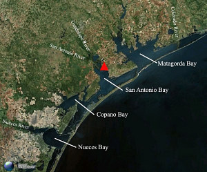
Aerial view of the central Texas coast showing the location of the Guadalupe Bay site. Base image from Microsoft Virtual Earth.
 |
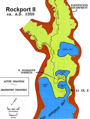
Paleogeographical interpretative reconstruction of the Guadalupe delta and upper San Antonio Bay area during the Rockport II occupation at the Guadalupe Bay site (41CL2) around 1350 A.D. Adapted from CEI graphic. |
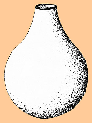
Idealized Rockport Black-on-gray bottle with the most common decorative variation, the "Steamboat Island" motif, consisting of a single band of asphaltum paint around the rim. Adapted from Weinstein 2002, Figure 7-36. |
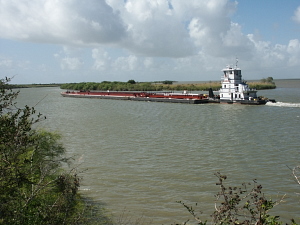
View looking out from the site at traffic on the Victoria Barge Canal. Guadalupe Bay is visible in the background behind the narrow, vegetation-covered bank of dredged spoil on the other side of the canal. Photograph by Steve Black.
|
|