University of Texas at Austin wordmarkUniversity of Texas at AustinCollege of Liberal Arts wordmarkCollege of Liberal Arts
Texas Beyond History
TBH Home
Trans Pecos Main
Prehistoric Texas Main

Explorations and Archeological Investigations

 
A page documenting Hueco Tanks pictographs from A. T. Jackson's "Picture Writing of Texas Indians," published in 1938. The pioneering University of Texas archeologist traveled across the state, recording a wide array of art which he further classified according to design elements. Enlarge image
photo of E.B. "Ted" Sayles' camp on January 1, 1932
E.B. "Ted" Sayles' camp on January 1, 1932 at the outset of his ambitious archeological survey of Texas, which included a stop at Hueco Tanks.. Sayles is sitting and petting his dog Happy. The other man is his field assistant, John (Juan) Olguin. TARL archives. Enlarge image
Watercolor depictions of rock art at Hueco Tanks
Watercolor depictions of rock art, or pictographs, at Hueco Tanks by Forrest Kirkland, one of 18 plates done by the artist for his 1967 book with William Newcomb, Rock Art of Texas Indians. TARL Archives. Enlarge image
photo of archeologist Ron Ralph and TPWD team
TPWD archeologist Ron Ralph and team members record a red pictograph of a horse during survey, a months-long effort to identify locations and status of rock imagery in the park. At right is Mike Bilbo who was instrumental in helping to locate many of the panels. Photo courtesy Texas Parks and Wildlife Department. Enlarge image
Cover of Kay Sutherland's book
Texas Parks and Wildlife produced a booklet by Kay Toness Sutherland incorporating Forest Kirkland’s watercolors and her interpretations of the of rock art at Hueco Tanks. Enlarge image
photo of John Davis, left, and Tom and Cynthia Martin of the El Paso Archaeological Society
John Davis, left, and Tom and Cynthia Martin of the El Paso Archaeological Society pause during survey of the park’s rock art. A research associate at the Centennial Museum of the University of Texas at El Paso, Davis led members of the EPAS and UTEP Anthropology Club in inventorying the park’s rock art in 1970. Photo courtesy Texas Parks and Wildlife Department. Enlarge image
photos of a pictograph symbol at Hueco Tanks shown before (left) and after (right) digital enhancement by Robert Mark
Pictograph symbol at Hueco Tanks shown before (left) and after (right) digital enhancement by Robert Mark of Rupestrian Cyberservices to reveal images that were not visible to the naked eye. Photos courtesy Texas Parks and Wildlife Department. Enlarge image

Our knowledge about Hueco Tanks and its people derives from a number of sources, chief among these archeological investigations and surveys conducted over the last 30 years. Some accounts and records, however, come to us from visitors who passed through the area in the mid-nineteenth century. Most of these are brief descriptions of the rocks, water, and rock art; some even include sketches or other depictions of the unusual combination of cultural and natural resources.

Archeologists and other researchers began visiting the site in the 1930s, but it was not until the 1970s that a systematic excavation was conducted, that being on a small Formative period village site at the base of the rocky hills. More recently, TPWD archeologists and photographers have conducted intensive surveys of the park to identify and document its cultural resources. Findings from much of this long-range program are still being analyzed, including information from 29 archeological localities and 273 rock art panels. In this section we look briefly at accounts of early visitors and more fully into records of investigations to understand how the dynamic story of Hueco Tanks has come to be known.

The Early Visits, 1849-1939

The earliest published historical accounts of Hueco Tanks were written by a few of the many travelers who stopped at the site during the mid- to late 1800s. In 1849, Captain Randolph Marcy of the 5th U.S. Infantry remarked about the pictographs. Benjamin Butler Harris also visited Hueco Tanks in 1849 and described one of the rock art panels.

A more-detailed account was provided by John Russell Bartlett, Commissioner of the United States and Mexican Boundary Commission. Passing through Hueco Tanks in November 1850, he was so intrigued with the unusual spot that he determined to revisit it, although, as he noted, “it was also a favorite place of resort for the Apaches.” On the return visit to Waco (sic) Tanks several months later, Bartlett and his party camped near a natural cavern in the rocks where, as he noted in his journal, they found excellent water. While there, he described the resources of the site and sketched some of the rock art in his journal. These are included in his Personal Narrative of Explorations and Incidents in Texas, New Mexico, California, Sonora, and Chihuahua 1850-1853 published in 1854.

Even at this early time, Bartlett noted defacing of the rock art. His description of one shelter where they camped states: "The recess formed by this rock is about fifteen feet in length, by ten in width. Its entire surface is covered with paintings, one laid on over the other; so that it is difficult to make out which belong to the aborigines. Similar devices cover the rock in every part, but are much defaced. Over these are figures of late travelers and emigrants; who have taken this means to immortalize their names, and let posterity know they were on their way to California."

During the first three decades of the 20th century, Hueco Tanks began attracting more attention from scholars and visitors with a serious interest in the rock art. In 1921 Frank H. H. Roberts of the Smithsonian Institution Bureau of Ethnology briefly visited the site and pioneer Texas archeologist A. T. Jackson of the University of Texas at Austin made brief visits in 1927 and later in 1935, discussing the pictographs in his book, Picture-Writing of Texas Indians. Colonel M. L. Crimmins published descriptions and sketches of several dozen pictographs, and categorized them as symbolic, animalistic, or anthropomorphic. He estimated that there were about 2000 pictographs, and recommended that the state of Texas acquire Hueco Tanks in order to preserve them. Hueco Tanks was one of more than 400 sites that Donald Brand visited during his 1930-1931 survey of Chihuahua for his dissertation research at the University of California at Berkeley, and E. B. Sayles also visited Hueco Tanks during his statewide Gila Pueblo Survey, collecting a small quantity of sherds and a handful of stone artifacts.

The first attempt to conduct an archeological excavation at Hueco Tanks may have been made by A. M. Woolsey in March, 1936, but his notes indicate that his effort was unsuccessful: “A trip was made to Hueco tanks on Friday, March, but no new caves could be found near the tanks. Sixteen caves were visited Sat. but none of these were considered valuable enough to work.”

Pictograph Recording

The first significant study of Native imagery, more popularly termed "rock art," at Hueco Tanks was accomplished by Forrest and Lula Kirkland, who spent 10 days there in the summer of 1939. Forrest Kirkland was an artist who made watercolor copies of hundreds of the pictographs. Among them were 89 masks which he discussed in a subsequent publication, noting their similarity and probable relationship with Hopi Katchina masks of New Mexico. Many of Kirkland’s watercolors were published in The Rock Art of Texas Indians in 1967, with a comprehensive discussion and analysis of the pictographs by W. W. Newcomb Jr. Kirkland’s watercolors are a valuable record and continue to be used by rock art scholars to study the extent of deterioration of the pictographs since 1939.

Over the next 30 years, there was virtually no organized pictograph recording or investigation at Hueco Tanks, mainly because the property was being used primarily for recreation and several land development enterprises. Acquisition by the state of Texas in 1970 created a renewed interest in the rock art and archeology of the park, particularly among members of the El Paso Archaeological Society (EPAS). Member John Davis was a research associate of the El Paso Centennial Museum, as well as advisor to the Anthropology Club at the University of Texas at El Paso. He proposed that the Anthropology Club inventory the rock art recorded by Kirkland 30 years earlier in order to assess its current condition and note the extent and cause of damage and/or destruction. Over 23 days from January through October 1972, members of the Anthropology Club and the Society—primarily Mike Bilbo, John and Marguerite Davis, Tom and Cynthia Martin, and Odin and Kay Toness—relocated and carefully inspected the rock art.

Their findings were published by the EPAS in 1974 (republished in 1997): A Rock Art Inventory at Hueco Tanks State Park. They determined that approximately 25 percent (n = 302) of the figures recorded by Kirkland had been destroyed. Of the 75 percent (n = 896) of figures remaining, about 50 percent had been damaged. The causes of destruction ranged from name writing to soot from picnic and camp fires, to natural causes (spalling, sun and water damage). An unexpected result of the project was the location of approximately 300 unrecorded figures. Toness (later Sutherland), who became professor at St. Edwards University in Austin, began an intensive study to classify and analyze the pictographs at Hueco Tanks.

After 1974, a hiatus occurred in studies and published accounts of rock art at Hueco Tanks until ca. 1988, when Texas Parks and Wildlife Department park ranger Dave Parker and archeologist Ron Ralph plotted all known rock art localities and archeological features on aerial photo mosaics. In subsequent years, Ralph also coordinated a group of TPWD employees and volunteers in recording pictographs at numerous locations and worked with Sutherland to determine methods for removal of graffiti from the art.

Advances in radiocarbon dating techniques led to the sampling of 15 pictographs at Hueco Tanks localities. Of these, seven yielded sufficient carbon for dating. Texas A&M chemist Marvin Rowe reported calibrated dates ranging from1350 ± 160 years ago to 740 ± 50 years ago, compared to expected ages of 950 to 500 years ago. Several problems, such as the unknown species of wood used for the charcoal, require that the dates be considered provisional rather than conclusive.

In 1999, TPWD began its most far-reaching rock art project, contracting with Robert Mark and Evelyn Billo of Rupestrian CyberServices to create a comprehensive digital database of all of the pictographs and petroglyphs at Hueco Tanks. The fieldwork involved recording GPS locations of 273 rock art panels, 34 of which were discovered during the project. Mark and Billo took more than 6,000 digital photographs of the rock art, which were then digitally enhanced by filtering different colors, revealing a number of images that were not visible to the naked eye. The images and locations were entered in an ArcView database which will be used to relocate and monitor changes in the recorded rock art sites.

1854 illustration of the Waco Mountain Pass
View of "Waco" Mountain and pass through the hills. This 1850s sketch was likely done by artist Henry Pratt, who accompanied U.S. Boundary Commissioner John Bartlett on the survey expedition to establish the border between the United States and Mexico, following the Treaty of Guadalupe Hidalgo.Enlarge image
A U.S. Geological survey photograph from 1909
A U.S. Geological survey photograph from 1909 shows a wagon making its way across the desert with Hueco Tanks rising in the background. Enlarge image
Estimating that there were some 2000 pictographs at Hueco Tanks following his 1930s survey, Colonel M. L. Crimmins recommended that the state of Texas acquire the property in order to preserve them.
photo of Forest and Lula Kirkland
Artist Forrest Kirkland and Lula Kirkland in camp during a rock art recording expedition. TARL Archives. Enlarge image
Purchase of Hueco Tanks by the the State of Texas in 1969 created a renewed interest in the rock imagery and archeology of the site.
photo of Centennial Museum researcher John Davis
Archeologist Bob Stiba records a pictograph variously termed a vinegaroon or a horned dancer. Photo by Darrell Creel, TARL Archives. Enlarge image
Cover of rock art inventory report.
Cover of rock art inventory report. Enlarge image
photo of Bob Mark of Rupestrian Cyberservices capturing a tight shot of rock art under a boulder while Evelyn Billo (left) and a crew member hold reflective panels to improve lighting
Bob Mark of Rupestrian Cyberservices, Inc., captures a tight shot of rock art under a boulder while Evelyn Billo (left) and a crew member hold reflective panels to improve lighting. The Rupestrian crews recorded more than 230 rock art panels and took more than 6000 photographs during their survey of Hueco Tanks. Photo courtesy Texas Parks and Wildlife Department. Enlarge image
photo of anthropologist Kay Toness Sutherland
A volunteer prepares to document a faint red pictograph in a shelter. Photo by Ron Ralph. Enlarge image
photo of excavations underway
Testing gets underway, with members of the El Paso Archaeological Society, on what turned out to be a small village site dating to circa A.D. 1100-1200. Photo courtesy Texas Parks and Wildlife.
illustration of the excavation plan at the Hueco Tanks village site
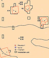
Excavation plan at the Hueco Tanks village site, showing locations of houses, burials, and other features (adapted from Kegley 1982: Fig. 2). Enlarge image
photo of the excavation crew
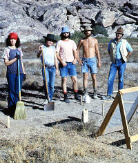
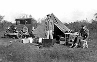
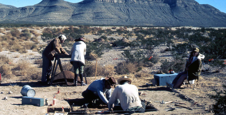
Excavation crew poses at the village site. From left, Carol Wagner, Don Broussard, Roy Brooks, Logan McNatt, and George Kegley. Photo courtesy Texas Parks and Wildlife Department. Enlarge image
photo of a collared post hole in House 5
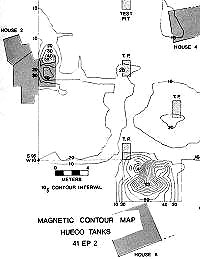
Magnetic contour map of Hueco Tanks village. The magnetometer survey, conducted by J. Barto Arnold III, detected numerous anomalies in the village area, including three additional pithouses. Graphic from Kegley 1982 (Fig. I-2). Enlarge image
Cover of the 1980 report of investigations at the Dona Ana village site by George Kegley
Cover of the 1980 report of investigations at the Dona Ana village site by George Kegley. Enlarge image
Drawing of cavern floor
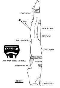
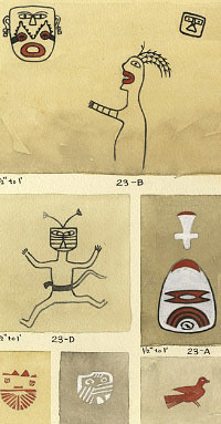
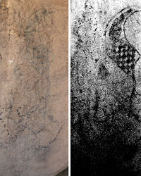
Drawing of cavern floor with small, catchment dam (shown at top) and “thirsty man” mask pictograph nearby. Tests dug into the cavern deposits produced pottery sherds and a few dart points. Drawing by John Davis as adapted in Kegley 1980 (Apx. VII). Enlarge image
photo of TPWD survey director Margaret Howard
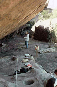
TPWD survey director Margaret Howard digs a shovel test near a park kiosk during the 1999-2001 survey project. Photo courtesy Texas Parks and Wildlife Department. Enlarge image
photo of Logan McNatt and another TPWD crew member
Logan McNatt and another TPWD crew member conduct tests near the historic stone ruins near park headquarters. Photo courtesy Texas Parks and Wildlife Department. Enlarge image
ghraph showing the correlation between feature size and type of rock used
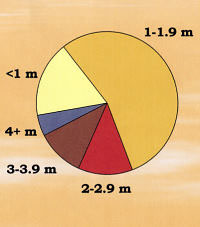
Variance in maximum size of burned rock features recorded during survey. Although analysis of data collected during survey is ongoing, small features predominated in this sample of 64 and there appears to be a correlation between feature size and type of rock used. Graphic courtesy of Margaret Howard. Enlarge image

The 125 visible fire-cracked rock features were concentrated in certain areas of Hueco Tanks, with 76 (61 percent) in one of the archeological localities.

Village Excavations

The only large-scale archeological excavations in the park uncovered the remains of a small Jornada-Mogollon village. In 1972, members of the EPAS and the University of Texas at El Paso Anthropology Club recommended testing of an extensive midden on the east side of the rock hills. Directed by TPWD archeologists George Kegley and Ron Ralph, subsequent excavations consisted of approximately 40 units. Two backhoe trenches were also dug. Most of the units were placed in blocks around three semi-subterranean pithouses.

House 1 contained two postholes and a collared fire hearth. A piece of wood from one of the postholes yielded an uncorrected radiocarbon date of 800 BP ± 50 years. Calibrated, the date is 733=/- 39 years, with a range of A.D.1178-1256, a span falling within the latter part of the late Doña Ana and early El Paso phase. Associated with the fire hearth were an ash lens, an El Paso Polychrome olla sherd, three stones, and bones from badger (Taxidea taxus) and pronghorn antelope (Antilocapra americana). House 2 included a collared fire hearth, an adobe block that may have served as a step, a possible collared posthole, an intrusive pit, and a burial. House 3 included a collared fire hearth, two postholes, and two intrusive pits. The pits appeared to be refuse deposits dating after abandonment of the houses, and contained dark grey ashy midden soil and bones of bison, deer, pronghorn antelope, grey fox, badger, jack rabbit, cottontail rabbit, pack rat, box turtle, and rattlesnake.

At the beginning of the 1973 season, a magnetometer survey was conducted in the midden area investigated the previous year. The purpose was to locate anomalies in the earth’s magnetic field that might be caused by subsurface cultural features such as pottery concentrations, burned pithouses, or fire hearths. Two survey techniques were used—a controlled systematic mode using 1 m intervals, and a less precise search mode that covered a broader area. Testing of the five anomalies located during the systematic mode found three pithouses, a concentration of ceramics and lithics, and an iron bar that was part of the 1972 survey grid. Six anomalies were located by the search mode and three were tested, but no cultural features were found.

The 1973 excavations covered approximately 75 square m (807 square ft), consisting of 75 units Most of the units were concentrated in blocks around the three semi-subterranean pithouses located by the magnetometer survey. House 4 was not completely excavated; features included a collared fire hearth with associated circular pit, and two postholes. House 5 was in poor condition and encompassed two floors. Upper floor features were two postholes, a shallow basin with a metate and mano in situ, and an intrusive pit. Partial excavation of the lower floor exposed a fire pit and a posthole. House 6 contained two large postholes and 14 smaller ones, a fire pit, and a small shallow pit.

To archeologist Ron Ralph, who served as crew chief at Hueco Tanks village, the houses were unlike any he had ever seen at the time, “all single structures, rectangular, dug in the ground, and all oriented north-south.” It was frustrating, he says, that they were not able to determine whether the houses were made of puddled (poured) adobe or wattle and daub (vertical poles and branches covered with mud). The corner areas were the best preserved, he recalls, with the best wall definition. “But once you found the corners, you knew you were at the end of the house. The plaster would lip up and then go away.”

Artifacts recovered from the excavations were dominated by ceramic sherds; nearly 34,000 were counted. Chipped stone artifacts includednearly 80 projectile points, bifaces and assorted other other tools, and more than 24,000 pieces of debitage (chipping debris).

Nearly 50 ground stone tool were recovered including 32 manos, 10 slab metates, and 5 basin metates; these were made from limestone, sandstone, and the local syenite porphyry. Two Olivella beads, one discoidal bead, a small pendant, and a bone awl made from a splintered deer bone also were found.

Further details on findings and more recent research is provided in the Village Life section.

Investigations of Water Control Features

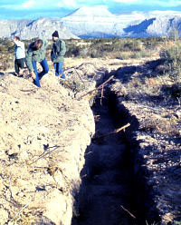
In conjunction with the 1972 excavations, a prehistoric water control system was investigated by the EPAS. Located in a large crevice on West Mountain, it consists of a man-made reservoir and two natural huecos. A rock dam had been constructed at a narrow point in the crevice to create the reservoir; the impoundment area is 30 m long and averages 3 m wide, and was estimated to have a maximum capacity exceeding 10,000 gallons. Two hand-excavated trenches in the reservoir fill yielded El Paso Polychrome and Chupadero Black-on-White sherds, and a variety of lithic items including two point fragments and three scrapers. The only pictograph in the reservoir area is a yellow geometric design that resembles designs on pottery.

Farther down the crevice are two large natural huecos that measure 5 m deep and have an estimated capacity of 780 gallons. Removal of the fill in one of the huecos yielded a dart point and dart point fragment, a handful of chipped stone flakes, and numerous sherds. The bedrock surrounding the huecos is highly polished, indicating long-term use probably by both human and animal visitors. The only pictograph associated with the huecos is a red mask that appears to have its tongue extended, possibly representing thirst.

Surveys and Ongoing Analyses

The 1970s saw a succession of projects initiated to record cultural resources prior to construction of trails, picnic areas, and other developments at Hueco Tanks State Historic Site. The numerous midden deposits and rock art localities throughout the park presented difficulties for any development, so a comprehensive set of guidelines was established to protect the sites. TPWD archeologist Ron Ralph recommended an intense 100 percent survey of the entire park and plotting all cultural resources on a topographic map all cultural resources including middens, rock art, pack rat middens, water control devices and surface artifacts.

Concerns about preservation of the site’s cultural and natural resources prompted development of a Resource Management Plan in 1998 and establishment of a Public Use Plan. To support increased stewardship of cultural resources, two inventory studies were initiated in 1999. As noted above known rock art sites were relocated and documented by Rupestrian CyberServices, Inc. Their findings are discussed further in the Rock Art section of this exhibit. Cultural deposits were inventoried by the TPWD Archeology Survey Team through intensive pedestrian survey of the ca. 500 acres of level terrain around the rock hills. The site was divided into 29 localities encompassing areas of moderate to high surface artifact density. Archeological localities were defined to encompass cultural deposits of a consistent density and type, but in areas where cultural deposits were continuous they were arbitrarily bounded at natural and/or manmade landmarks, to provide convenient units for analysis and management.

Survey took place over 141 person-days, for an average of 3.5 acres per person-day. The density of the cultural materials and features exposed on the surface necessitated this slow pace. With crew spaced at 20 to 30 meter intervals, the features and time-diagnostic, nonlocal, and distinctive artifacts were flagged for recording or collection. Data collected include time-diagnostic artifacts (e.g., dart and arrow points, rim sherds, and decorated prehistoric and historic ceramics), materials suitable for radiocarbon assay, and information on the location and stratigraphy of cultural deposits.

The locations of collected artifacts, artifact concentrations, burned rock features, bedrock grinding features, middens and ashy soils, rock art panels, water control features, rockshelters, shovel tests, and significant natural features like water chutes were plotted on detailed maps derived from aerial photographs, at a scale of 1 inch = 100 ft/30 m. Large-scale aerial-based maps (1 inch = 200 ft/61 m) were used for localities where cultural materials and/or features were dense. Cultural features were briefly described, mapped, and photographed.

One to two shovel tests were dug in each archeological locality to sample the depth, stratigraphy, and integrity of the cultural deposits, and to facilitate collection of sediment samples for flotation and pollen analysis. Rockshelters were not tested due to their great number and the possibility that they could contain human burials.

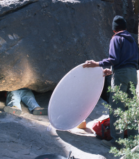
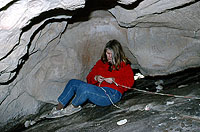
Additional survey, this time in the lower elevations of the hills, was instituted when it became apparent that these areas were replete with rock art, cultural features, and historic graffiti. Natural features like water chute scars and rockshelters also were recorded, the latter defined as areas enclosing at least 10 square meters. Reconnaissance of the hills reached a height of 10 to 20 ft above ground surface as possible. A 100 percent survey of the hills was difficult to achieve because the rock surface is complex; many pictographs and other features are only visible under specific conditions (e.g., by early morning light in spring, on overhanging surfaces).

Preliminary analyses indicate that the 29 archeological localities defined in this area were occupied primarily during the Formative period, with Archaic occupations at half of them and one Paleoindian occupation. Most of the typed ceramics represent the late Formative period, while most of the projectile points are affiliated with the Late Archaic period. The relative abundance and types of nonlocal ceramics suggest that interaction during the Formative period was primarily with areas to the north. Ongoing analyses include ceramic and lithic source identification, radiocarbon assays, and flotation of midden sediments to recover pollen and/or plant remains.

It is clear that the state historic site contains significant cultural resources, with considerable potential to address questions in major research domains. Further analyses will help more clearly define the site’s context in regional prehistory and history and yield substantial information that can be used to interpret the site for the public. These include regional questions of chronology, settlement and subsistence, interaction, and historic occupation.

Further, the location and distribution of cultural resources identified through these varied investigations is being used to guide trail planning and to delineate visitor access zones, with careful attention paid to how to preserve and protect the park's cultural heritage.

photo of pne of the two trenches dug through the midden area
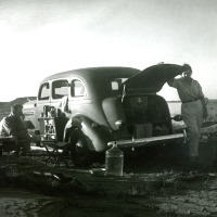
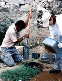
Two trenches dug through the midden area helped investigators understand the nature of the deposits. Photo courtesy Texas Parks and Wildlife Department. Enlarge image
photo of the excavation of one of the basin metates
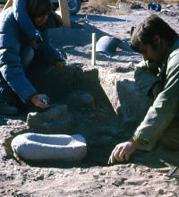
Excavation of one of the basin metates. Image courtesy of Texas Parks and Wildlife Department. Enlarge image
illustration of plan of House 4
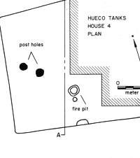
Plan of House 4 and section, showing adobe wall remnant, post holes and firepit. Drawing from Kegley 1982 (Figure 8).
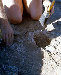
 Enlarge image
photo of a collared post hole in House 5
A collared post hole in House 5 is brushed clean for closer viewing. Image courtesy of Texas Parks and Wildlife Department. Enlarge image
photo of TPWD crewmember Dave Parker
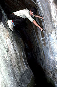
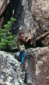
TPWD staff member Dave Parker points out the high water mark on a wall behind a small prehistoric “dam” in a deep crevice. Tank capacity is estimated at 10,000 gallons, and water still stands periodically in this feature. Photo by Ron Ralph. Enlarge image
photo of TPWD archeologist Ron Ralph
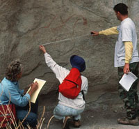
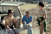
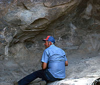
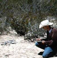
TPWD archeologist Ron Ralph checks a rock art location at the park.
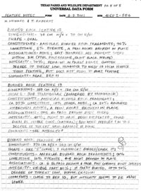
 Enlarge image
Documentation of some 125 burned rock features
Documentation of some 125 burned rock features included extensive description, measurements, photographs, and shovel tests. The form shown, two of five pages for one feature recorded by TPWD archeologists Margaret Howard and Tim Roberts, indicates the level of detail required. Click to see full image. Enlarge image
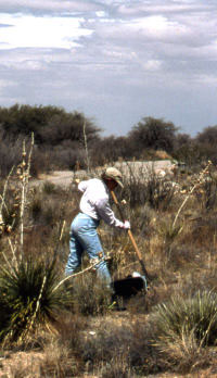
A crew member records a burned rock feature amid the desertscrub. Photo courtesy Texas Parks and Wildlife Department. Enlarge image
photo of of arrowpoints recovered during investigations
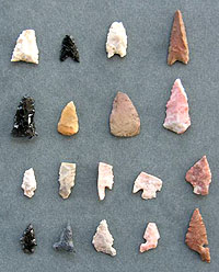
Examples of arrowpoints recovered during investigations. Photo courtesy Texas Parks and Wildlife Department. Enlarge image
photo of investigation of a rock shelter
Rockshelters were investigated during the months-long survey, and features such as the bedrock mortars, shown in forefront, recorded. Photo courtesy Texas Parks and Wildlife Department. Enlarge image