Reconstructing the Paleoenvironment
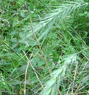
Bison graze near a boggy depression filled with rainwater. Over time, the area saw periodic changes from cooler and more moist climates to drier and more arid conditions. These environmental fluctuations were tracked through a variety of analyses, providing an important framework for evaluating the cultural evidence on West Amarillo Creek. During their occupations, When Late Archaic and Protohistoric groups camped in the area, the stream valley contained ponds and marshlands, edged with grasses. Photo by Mike Quigg. |
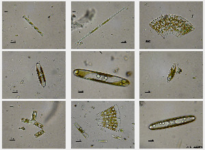
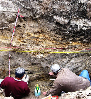
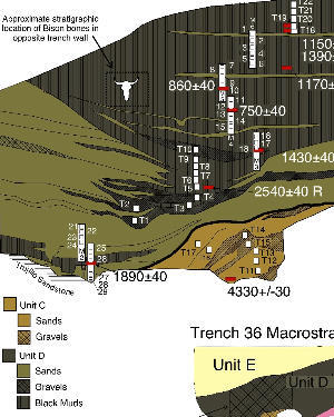
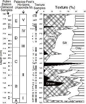
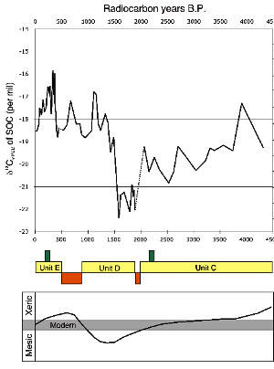
Paleoenvironmental reconstruction is a key tool for understanding how peoples of the past made their living and perhaps even why certain locales were selected time and again for campsites. Depending on severity, climatic fluctuations could significantly impact plant and animal communities and, by extension, the Native groups who depended upon natural resources. During the Landis project, environmental changes during the late Holocene were documented through a variety of analyses, including determining the presence or relative abundance of environmentally sensitive plants and animals. Alluvial deposits revealed complex histories, including evidence of floods and drought, as well as more stable conditions. Sediment samples were collected for a variety of technical analyses on pollen, phytoliths, diatoms, ostracods, stable carbon and nitrogen isotopes, and mollusks (see Clues to Past Environments for more detail). Thirteen radiocarbon dated samples from selected depositional units were used to document the past environments at specific points in time during the last 10,000 years. Weaving together these various lines of data suggests a dynamic mosiac of environments in this area, fluctuating periodically from cool and moist periods, when West Amarillo Creek flowed more regularly to dry and warm conditions, when ponded wetlands prevailed. Pollen and Phytolith EvidencePollen and phytoliths extracted from dated samples provide a point-in-time glimpse of the broad changes that occurred in the paleoenvironment here in the upper reaches of West Amarillo Creek. In general terms, the early Holocene period (ca. 10,850 B.P.) was relatively cold, with mostly grassland vegetation and a few deciduous trees and shrubs. A gradual warming trend occurred over the next thousand years or so. By about 8280 B.P., however, the area once again had cooled. Cool season grasses (C3) dominated, and more deciduous trees and shrubs were present. These indicators point to temperature similar to earlier (at 10,850 B.P.). By 4330 B.P. the conditions were much warmer and drier with increases in short, warm season (C4 ) grasses. This created a grassland-dominated region containing far fewer deciduous trees and shrubs. The pollen and phytolith assemblage at 4330 B.P. is very similar to that at 9600 B.P. By 2250 B.P. vegetation consisted of slightly more humid grassland with few deciduous trees and shrubs. At 1890 B.P. it was much warmer and more arid with increased C4 (warm season) grasses. Pine pollen had blown in from distant sources to the west. A major change occurred around 1840 B.P. with cooler conditions, based on the increase in mid to tall, cool season (C3) grasses. However, over the subsequent 400 years or so, conditions again warmed and became drier, with another increase of C4 grasses and decrease in C3 grasses. Willow pollen decreased at that time, which also indicates a warming trend. Another cooling was evident by 1430 B.P., with conditions similar to those at 1840 B.P. Another shift followed. By 860 B.P. conditions had again warmed and dried with few C3 grasses and an increase in C4 grasses. Pine pollen had again increased which may reflect a regional drying trend. The absence of oak and willow pollen also may indicate increased aridity. This general warming trend continued until ca. 600 B.P. when local conditions were much cooler, based on the higher frequencies of the C3 grasses. Another change occurred with a more arid and warmer environment by 300 B.P. as reflected by the increase in C4 grasses. In summary, the changing frequencies in pollen and phytoliths over time reflect a dynamic vegetation history and paleoenvironment for the West Amarillo Creek valley, here in the Texas Panhandle. Alluvial Deposits and Carbon IsotopesTracking changes to the climatic conditions through the various depositional units is a relatively subjective approach. Here, we examine the variations in the stable carbon isotopic composition of the organic carbon in alluvial deposits through the last 4,500 years (Units C, D, and E; see graphic at right) as a proxy record for changing vegetation within the West Amarillo Creek valley. Previous investigations across the region also reflect this broad pattern of vegetation change. There is a fluctuating trend of decrease in C4 plant matter which reflects an increase in moisture to a peak in Unit D, between 1900 and 1450 B.P. Immediately following that time and extending to about 1200 B.P. there is a dramatic increase in C4 matter (from below 40 percent to nearly 74 percent). This increase is followed by continued fluctuations ranging up to 20 percent. The primary difference between this sequence and previous work in the region around Lake Alan Henry, located just off the eastern Escarpment, is the specifics of timing of the maximum period of wet (mesic) conditions. For a more in-depth reconstruction of the last 2,000 years, a single 5-m tall column of sediment exposed on the valley floor in backhoe trench 36, next to the Pipeline site (41PT185), was targeted. This time frame, from roughly 1890 to ca. 430 B.P., is represented by depositional Unit D, which was tested through multiple samples. Again, a multi-disciplinary approach was used to investigate this period through pollen, phytolith, and diatom analyses. Selected samples were analyzed for micro-invertebrates (snail shells and mollusks), calcareous algae, and stable carbon isotopes from ostracods. The initial period of deposition of Unit D (ca. 1900 to 1430 B.P.) was followed by a period of channel entrenchment when the stream carried a high sediment load. Soon after, a year-round pond/marsh was established in the stream bottom with some intervals of flowing conditions within a sandy channel. Both the diatoms and the ostracods indicate that this early wetland contained a fluctuating level of moderately alkaline, shallow water with emergent vegetation, such as cattail, sedges, and willow trees that lined the banks. The snail fauna of this early pond was primarily terrestrial, which is at odds with the clear evidence of wetland conditions. During this period a complex suite of microenvironments ranging from sandy mud flats to small pools existed. Towards the end of this period a series of larger magnitude floods occurred that deposited several beds of gravel. In broad terms, this is considered a cool and moist period. Around 1400 B.P. a more persistent wetland became established, which varied between a marshy wet meadow and periods when deeper pools and ponding water prevailed. Cottonwood and oak trees replaced willows. Water salinity and alkalinity varied throughout this period. Sometime around 800 B.P., and before 430 B.P., the water levels declined and the valley floor shifted to a sandy bottom that was often dry. Occasionally, isolated marshy areas existed. This is more of a gradual warming and drying period. The very end of Unit D reflects a subtle trend to cooler and moister conditions and may have triggered the incision of the creek channel prior to the deposition of Unit E. Combining the evidence from archeological, depositional, and paleoenvironmental investigations provides a deeper understanding of the local and regional environments in which the prehistoric populations lived. In particular, these investigations set the scene for evaluating the cultural evidence left by Late Archaic and Protohistoric groups on West Amarillo Creek. |
|