Occupational Evidence
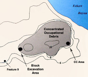
The occupational debris was concentrated at the northeastern end of Mitchell Ridge near Eckert Bayou. The largest and most informative samples came from the CC Area excavated in the 1970s, the Block Excavation Area, and the overlapping set of large pits known as Feature 9. |
|
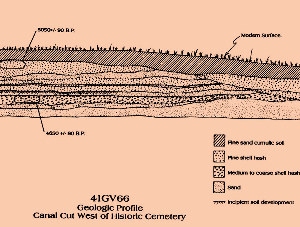
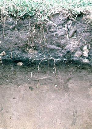
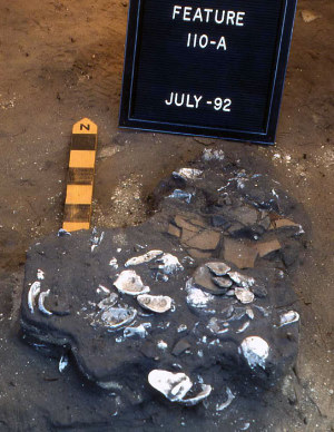
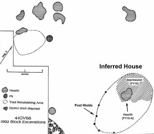
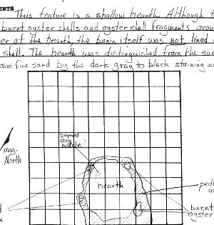
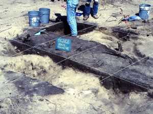
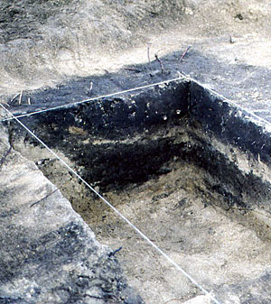
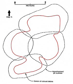
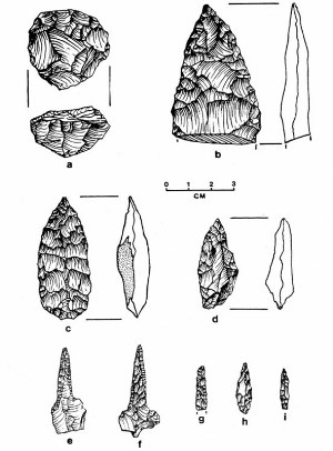
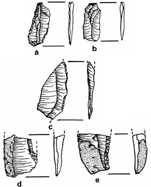
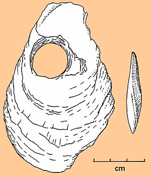
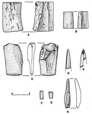
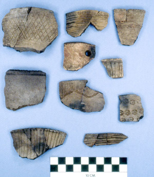
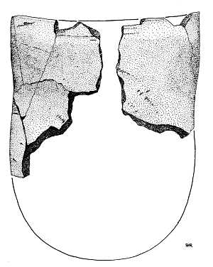
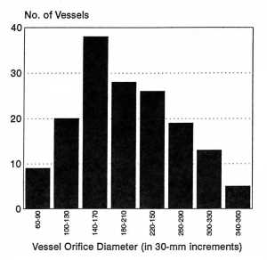
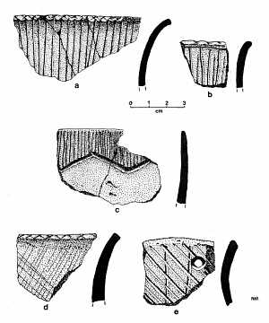
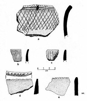
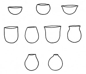
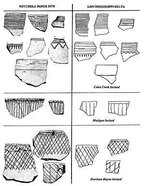
In this section we review certain of the critical data from the Mitchell Ridge investigations that provide the evidence for site interpretation. Most of this evidence comes from the occupational remains left behind by the aboriginal peoples who camped at the site during the Late Prehistoric and Protohistoric periods. The occupational debris was concentrated at the northeastern end of Mitchell Ridge near Eckert Bayou. Given the repeated observations that wave action steadily eroded the northeastern edge of the site along Eckert Bayou throughout the 1970s and 1980s, it is obvious that a considerable amount of occupational materials eroded away as well. Nevertheless, very good samples were obtained by excavation. The largest and most informative samples of the occupational evidence came from the CC Area excavated in the 1970s, the Block Excavation Area (1992), and the overlapping set of large pits known as Feature 9 (1992). Additional information was obtained from surface collections and various excavations and machine scrapings during the 1990s and 1970s. StratigraphyThe natural and cultural layering at the Mitchell Ridge site was found to be relatively simple and straightforward. In general, the archeological materials occurred within a dark brown sandy soil that overlies “culturally sterile” light-colored shell hash and sand deposits. The uppermost underlying sterile deposits are laminated – in other words, separated into relatively thin layers of fine shell hash, pure sand, and coarse shell hash. These layers are thought to represent storm storm “washover” deposits, rather than original beach sand. Below these thin layers is a massive more or less pure sand layer of unknown thickness that represents the original “core” of Galveston Island. See the Setting section for information on how the island is thought to have formed. The dark brown sandy soil varied in thickness from 40-60 centimeters (16-24 inches).Its dark color is the result of decomposed organic material (leaves, roots, etc.). The sand is fine grained and was probably mainly aeolian in origin and represents wind blow sand from the dunes behind the beach. The sand accumulated gradually and was (is) in the process of becoming a true soil, meaning that it had been more or less stabilized (stopped accumulating) by vegetation and natural horizons or zones were beginning to form as the result of the addition of organic material at the surface, biological activity (such as worms), and chemical weathering (such as that caused by rainwater percolating through the sand). No need to delve into the technical details, but soil scientists view “soil” as something more than just “dirt.” During the 1992 Block Excavation researchers paid keen attention to subtle differences within the dark brown sandy soil. They were able to distinguish three “zones” within it, although these were not clear-cut strata (layers) as they graded into one another and part of the distinction was based on the presence of abundant cultural debris (especially pottery sherds and oyster shells) in the middle zone (#2). All three zones had the same basic fine sandy soil with slight differences in color and content. The uppermost Zone 1 was about 15-20 centimeters thick (6-8 inches) but this is misleading because the surface of most of the site had been disturbed by previously land clearing. In other words, prior to modern times, Zone 1 was probably somewhat thicker. Zone 1 was found to be practically devoid of cultural materials, except for an occasional aboriginal artifact or animal bone probably displaced by bioturbation (such as gopher holes and tree roots). Zone 2 had concentrated aboriginal debris as well as a barely perceptible darker color. This darker color probably reflects the human additional of organic materials, such as rotting food remains and ash and charcoal from hearths. Zone 2 was only about 10-15 centimeters thick (4-6 inches). Various cultural features were found within Zone 2 including hearths and lenses of oyster shell. Zone 3 was usually 10-15 centimeters thick as well and the same dark brown color immediately under Zone 2, but gradually graded into a lighter brown color near its base (the contact with the light colored shell hash). The contact between Zones 2 and 3 was quite clear during excavation – the cultural debris so common in Zone 2 abruptly ceased to appear under the trowel. [The excavation of Zone 2 was done by hand using trowels to scrape off very thin layers a bit at a time. Experienced excavators can detect differences in texture and content very quickly.] The straightforward stratigraphy just described did not always hold true. In some areas of the site the modern disturbances mentioned disrupted the layering, as did aboriginal peoples when they dug pits for storage and for burials. These pits were usually hard to detect in the dark upper soil where color differences were subtle, but the pit outlines stood out sharply when the upper soil had been stripped away. The aboriginal pits dug into the light-colored sterile layers were characteristically filled with the dark brown sand. As explained in the Investigations section, this is how most of the burials were found during the 1992 work. Occupational FeaturesNumerous cultural features – distinct localized patterns often representing individual events and that stand out in contrast to their surroundings – were encountered at Mitchell Ridge that are associated with site occupations—evidence of camp and daily life. The graves (burials) are considered mortuary features (as opposed to occupational features) and discussed in the Mortuary Patterns section. Here we summarize and give examples of the other types of cultural features documented during the 1992 investigations. Of the 50 definite or probable aboriginal features recorded in 1992, 22 proved to be grave pits.The non-burial features included 13 definite and two probable hearths, 10 definite and two probable aboriginal pits, two clusters of post molds though to represent small circular structures (huts), and one small concentration of cultural debris. There were an almost equal number (52) of historic or modern “anomalies” (technically, features as well) including trash pits, post molds representing old fence lines, and burials of pets (dogs and a cat) and farm animals (goat, sheep, horse). Several dog burials had been encountered in the 1970s and were assumed to be aboriginal in origin, a reasonable assumption given the well known fact that native peoples elsewhere in Texas and North America had dogs and sometimes purposefully buried them. During the 1992 work, four additional dog burials were found and these too were at first assumed to be aboriginal. This notion was contradicted by the evidence. A modern radiocarbon date was obtained from one dog burial and it was recognized that most of the dog and livestock burials were clustered near the location of a 20th century “farmhouse” (rural residence) that once stood on the site. Back to the aboriginal features. The most common non-burial feature proved to be hearths, relatively small concentrations of charcoal-stained soil sometimes lined by oyster shell or pottery sherds and often containing animal bones or shell, some of which were burned. Most hearths were less than 60 centimeters (2 feet) across. In cross-section most were shallow basins. Such features are often informative because they contain direct evidence of what people were eating and because some yielded charcoal (bits of charred wood), an ideal material for radiocarbon dating. The hearths likely served two functions – cooking and providing warmth. It is reasonable to infer that the smaller hearths had been located either within huts or just outside such dwellings. While unequivocal evidence of houses could not be detected in association with most of the documented hearths this is not surprising. Ethnohistoric accounts suggest that the houses of coastal peoples were quickly constructed brush-frame huts that would have left few obvious traces. Five hearths were lined with oyster shells. Shallow basin-shaped holes were scooped out in the sandy soil and lined whole oyster shells, atop which the fire was built. This arrangement would have separated the fire from the damp earth, which otherwise would have “wicked off” the heat. The shell lining would have both held heat and reflected upward, although not near as effectively as stones had these been available. Feature 110-A provides a particularly fascinating example of a lined hearth. This feature measuring 76-x-24 centimeters was lined with both oyster shells and large fragments pottery. The shells were intensely burned and the soil matrix was carbon-stained. The pottery sherds were from three different vessels, which shows, coupled with the fact that the sherds were lying flat as were the oysters, that this lining was purposefully constructed. No doubt the sherds represent the recycling of large fragments from broken pots. The edges and surfaces of the pottery were also oxidized to bright red or orange color, showing that they had been subjected to the intense heat generated by an open fire built directly atop the pottery-shell hearth lining.. Feature 110-A, was associated with Feature 110, a depression thought to represent part of the floor of an aboriginal house. This depression was clearly visible because it extended downward from Zone 2 into the lighter colored Zone 3 and bottomed out at the top of the underlying shell hash layer. Feature 110 was semi-circular and measured about two meters across (seven feet), although this dimension appears to reflect only the width of the inferred structure. The southwestern edge of the depression was irregular and hard to define (probably because of bioturbation). About two meters farther to the southwest an arc of six post molds was documented. Post molds are small circular dark organic stains caused by the decay of wooden posts, such as those used to build huts. The arc of post molds mirrors the curving northeast edge of the pit. Putting the patterns together, we infer that they represent traces of an oval-shaped aboriginal house – a simple hut – measuring about 2.5-x-4.2 meters. The house (“domestic structure”) would have had a framework of flexible wooden poles (such as willow) shoved into the ground and bent toward the middle and tied together. Atop the framework would have been mats of woven leaves (such as those of the bulrush which grows thickly around the freshwater swale ponds on Galveston Island) forming the walls and roof of a dome-shaped hut. Spanish accounts describe native peoples of the upper Texas coast living in just this sort of quickly constructed, easily moved structure. In the case of the Feature 110 complex, the depression can be explained as the result of repeated use of the structure perhaps over no more than a few weeks time. The loose sandy soil is easily compressed by traffic and may have been scooped out shallowly and smoothed for comfort. The hearth, especially during the cooler times of the year when the site was most likely occupied, would have been the center of life within the hut. The 12 definite or probable aboriginal pits included several small pits (less than 40 cm diameter) as well as larger pits; most were relatively shallow basins. Some had little in them, others had quite a lot of debris, especially animal bones. Determining the original function of such pits is challenging as it is clear that many were filled with discarded refuse. In many native societies across North America storage pits were filled with debris after they were no longer in use. A similar explanation is favored here for most of the pits. A complex set of overlapping pits illustrates the challenge of definitively interpreting the aboriginal pits at Mitchell Ridge as well as the importance of these features as discrete and relatively well-preserved samples of occupational debris. Feature 9 was encountered as a very large, oval-shaped, dark stain (3-x-5 meters) during machine scraping in Area 3 and flagged off as an anomaly and obvious aboriginal feature – pottery sherds and animal bone fragments were visible at the encounter surface. Upon excavation the feature proved to be an overlapping set of four pits circular to oval in outline shape and 2-3.5 meters in maximum extent. Three of the four extended deeply into the tan shell hash layer, the deepest was some 80 centimeters below the detection surface. A contour map of the bottom of the pit complex shows three of the pits clearly, the fourth was apparent in cross-section. The Feature 9 pits were filled with very dark sediment of the sort archeologists often call “midden” soil. The intensely dark color was created by decomposed organic material such as plant refuse and animal bones. In this case several matrix samples of the pit fill were processed using flotation techniques in the hopes of finding charred plant remains. Except for a very few tiny fragments of charcoal which were used for radiocarbon dating, no identifiable plant remains were found. Nonetheless, as the pictures attest, the pit fill was very, very dark. The upper fill was chock full of debris including pottery sherds, broken stone tools and tool-making debitage, and many animal bone fragments. There was also debris in the lower fill, but it was not as dense. Overall, Feature 9 yielded one of the most informative samples of occupational debris from the site. To date the feature, two radiocarbon assays were run. One from the top of the feature proved to be modern in age, which is not surprising given that modern trash and small trash pits were found elsewhere in Area 3. In other words, the presence of a small amount of modern charcoal in the uppermost part of the feature can be readily explained by recent activities. The other sample was recovered from 10-20 centimeters below the detection surface and was dated to about 400-500 years ago (A.D. 1500-1600). The complete absence of items of European origin (such as glass or metal) coupled with the finding of several arrow points thought to date to very late times (Bulbar Stemmed and lozenge-shaped points) is consistent with the radiocarbon date. The presence of a few Perdiz points suggests that the pits were in use in latest Prehistoric times and during the early Protohistoric period. The intense organic staining coupled with the concentrated debris suggests that the pits were intentionally filled with refuse. Laminations of culturally sterile sand and fine shell hash found in the lower part of Feature 9 could suggest the intentional covering of rotting debris prior to final infilling of the pits with additional trash and organic refuse. However, the original function of the complex of pits is speculative. Given the fact that Area 3 is immediately adjacent to the low ground below the ridge where occupational evidence was concentrated, it seems unlikely that the pits were merely used as refuse disposal. It would have been much simpler to merely toss debris downhill than to dig substantial pits. One possibility is that the pits could have been used to trap cotton rats. Numerous rat bones were found in Feature 9 as well as elsewhere at the site, showing that these rodents were common on the island and regularly eaten. The rat trap idea, however, seems unlikely given that the Feature 9 pits did not have steep sides. The intentional excavation of a series of sizable pits is perhaps most reasonably interpreted as resulting from the creation of short-term, subsurface storage facilities, perhaps for gathered plant foods. Cabeza de Vaca mentioned roots as an important dietary staple. If these pits did serve as “root cellars” so to speak, it is apparent that, once the pits no longer served their storage function, they were used as convenient trash receptacles. It is perhaps telling that the artifacts and bones were concentrated in the upper part of the feature. Material CultureHere we summarize the “material culture,” meaning the physical objects recovered from the occupational areas of Mitchell Ridge that were left behind by the native peoples who frequented the site. These objects include stone tools, bone and shell artifacts, pottery, and faunal remains. Keep in mind that we are not including the materials found with the burials in this section. As would be expected from a barrier island locale far from any sources of stone, only a modest amount of stone tools was recovered from the site. The lithic assemblage from the occupational areas of the site, however, provides evidence of dating, activities, and patterns of landscape use. Projectile points are the most common stone tool form, and 68 of these are arrow points and fragments there of. Of those identified as to type, 43 (75%) are of the Perdiz style, which dates to the Final Late Prehistoric period, ca. A.D. 1250-1500. Perdiz points occur very widely across much of Texas during this interval of time. Although Lee Patterson has suggested that the style may have originated around A.D. 900 in Southeast Texas, there is little compelling evidence to support this idea. There is, however, one intriguing case that shows that Perdiz points overlapped in time in the early 13th century. At the Oxbow site in Fort Bend County about 50 miles northwest of Mitchell Ridge, a male burial was documented that had five arrow points in the chest and body cavity including two Scallorn points, a Perdiz point, and a Bonham point. The burial was radiocarbon dated to around A.D. 1225 (calibrated midpoint). The other distinctive arrow points from Mitchell Ridge occupation areas include two Scallorn points dating to the Initial Late Prehistoric period as well as, a Cuney point, a Bulbar Stemmed point, and four lozenge-shaped, and various small triangular points, all of which date to the Final Late Prehistoric or Protohistoric periods. There were also two unidentifiable dart points, although several other dart points have been said to have been found on the shores of Eckert Bayou. All in all, the projectile points strongly support the radiocarbon evidence for when Mitchell Ridge was occupied and used as a cemetery. The arrow points also point to the importance of hunting, as is indicated by the fact that deer were second to only fish as providing the most meat for those who camped at the site. The evidence for deer hunting, however, raises a curious finding. There were very few stone tools used for butchering and hide preparation. Only a single bifacial knife and a single end scraper were recovered. Two possible explanations seem tenable. First, it is possible that deer processing activities took place elsewhere. Although deer were observed in early historic times on Galveston Island, there is little suitable deer habitat. In contrast, deer are widely available on the mainland and many contemporary archeological sites there have provided good evidence of deer hunting and processing. Still, given that a fair number of deer bones were found at Mitchell Ridge some butchering and hide work probably took place here. Given the scarcity of stone tools and the fact that almost all of those present were small in size, it may be that deer processing was accomplished with shell tools. Elsewhere in the upper and central coast, cutting and scrapping tools made of oyster and other shells are known. With a few possible exceptions, these were not present at Mitchell Ridge. This, however, may be due to the fact that most oyster shells were poorly preserved, especially the thin edges which would have been used as tools. The second most common stone tools were small drills. These were most likely used for making holes in relatively soft material, such as leather, as these are not very sturdy tools and few have the obvious use wear that drills used on harder materials such as hardwoods and shell. There were 3200 pieces of debitage – flakes, blades, and fragments thereof from chipped stone tool making debris. Actually, there was only a little evidence of tool making from scratch – a couple of small cores (parent pieces) and hammerstones. Thirty-seven small prismatic blades show that the Mitchell Ridge folk made at least some use of the distinctive stone technology (blade making) that rather suddenly reappeared in the archeological record of Texas during Final Late Prehistoric times after an absence of 10,000 years. As archeologists are wont to do, Ricklis did a detailed technological study of the debitage and compared that against data from studies he had previously conducted along the central coast. Those interested in the technical details can read the lithics section of the site report. But here are some highlights. The Mitchell Ridge debitage assemblage showed patterns that are for the most part quite consistent with expectations based on the simple fact that the nearest sources of tool-making stone (flint, also known as chert) are distant. One must travel at least 75 kilometers from the mainland shore to find the nearest raw materials: small to medium-sized chert cobbles. These can be found in gravel deposits along the Brazos and Trinity Rivers. Evidence suggests that such rocks were seldom lugged back to Galveston Island. Namely, there were comparatively few “primary” and “secondary” flakes at the site, compared to “tertiary” flakes. Said more plainly, over 70% of the flakes lacked any cortex, the outer rind of a chert cobble. The high percentage of tertiary (also called interior) flakes, and the fact that most were tiny, shows that these did not result from tool-making, per se, but rather from edge resharpening (tool maintenance). Other technological patterns also fit. For instance, the flake to tool ratio from Mitchell Ridge was 29:1 whereas inland locales close to raw material sources have ratios of over 150:1. This makes sense – when people had easy access to chert they had material to waste, so to speak, whereas those along the coast had to use what little stone they had efficiently. This same factor can be seen in comparisons of the length of Perdiz points. Those from Mitchell Ridge averaged about 2 centimeters in length, compared to almost 3 centimeters from sites near lithic sources. One curious pattern required some thinking to explain. A study by Ricklis and Kim Cox of the lithic technology in the central coast showed that the percentage of flakes that had been used as simple “expedient” tools increased relative to distance from source areas. In other words, the farther from the sources, the more likely it was that chipped stone debris was used for cutting and scrapping tools. Given this pattern, it was expected that there would be a relatively high percent of “utilized” flakes at Mitchell Ridge. Not so, the percentage was very low, about the same as that at sites near raw material sources. A likely explanation for this unexpected pattern emerged from the flake study details. The Mitchell Ridge debitage was quite small in average size compared to that from other sites. Therefore, it seems reasonable to infer that the available flakes were just too small to be very useful as tools. Given the good preservation of bone and the large number of shells (if not very well preserved), the number of bone and shell artifacts from the occupation area was quite small: 21 bone artifacts and 12 of shell. Scarce, but surprisingly diverse in form and function. Among the bone artifacts were four “awls,” two smoothed rectangular pieces that might be pottery polishing tools, two rectangular pieces of bone, a socketed projectile point, an unsocketed point, eight bird bone beads, and two whistle fragments. What archeologists call “awls” are pointed tools often made out of deer bones that likely represent weaving or basketry tools used to make fiber artifacts such as baskets and mats. Judging from similar specimens found on Florida coastal sites, the rectangular bone pieces could be net-spacers used in the making of fishing nets to ensure a regular mesh size. The shell artifacts include four bi-pointed pieces of whelk columella (projectile points?), a whelk adze fragment and another whelk fragment with a chisel-like end, three perforated oysters (net weights?), a single oyster tool, and one shell bead. The diverse array of bone and shell artifacts in such a small assemblage shows that the Mitchell Ridge inhabitants made creative use of the raw materials they did have access to. There can be no doubt that they also made and used an array of perishable artifacts made of wood, fiber, and leather, as was characteristic of hunter-gatherers elsewhere in North America. With a total of 26,583 pottery sherds, the Mitchell Ridge site has yielded the largest sample of aboriginal ceramics from any single site on the upper Texas coast. As such, the Mitchell Ridge pottery offered author Ricklis with "an unusually good opportunity to example upper coastal ceramics from the perspective of both technological and stylistic attributes" as he put it in his 1994 report. Serious students of archeology can download the ceramic section of the site report. Here is a succinct summary of what was learned. Previous studies of the aboriginal pottery from the upper Texas coast have focused on those attributes (specific characteristics such as temper type) that seemed to lend themselves to chronological placement. Aten's seminal typology and chronology of upper coastal ceramics in his 1983 book Indians of the Upper Texas Coast has served as a guide for many researchers. In a nutshell, most upper coast pottery is undecorated, made in simple bowl or jar forms, and primarily made out of sandy clay ("sandy paste"). Essentially all sandy paste pottery is classified within the Goose Creek typological series, while pottery with grog temper (purposefully added crushed pottery fragments) is assigned to the San Jacinto series. Pottery with bone temper constitutes a small third grouping, generally lumped together into a generic category not given a type name. Although most pottery in both type groups are undecorated (plain) sherds, those with decorations such as incised lines, rim modifications such as scalloped edges, and, rarely, red coating ("red filmed") are considered informative because the decorative attributes are used to define types and varieties. Goose Creek Incised and San Jacinto Incised are the most common decorated styles. Almost all upper coast pottery is fragmented and recovered as sherds (shards). Because of the friable nature of the pottery, intact pottery vessels have never been found in the region, although large sherds and refitting sherds have allowed researchers to reconstruct vessel forms. Rim sherds and reconstructed rim sections are especially informative because these often indicate vessel form and because most of the decorative elements occur along the rims and in the upper part of the vessels. The first pottery to appear on the upper Texas coast (by 200 B.C. or somewhat earlier) was an untempered ceramic ware with a contorted paste similar to pottery farther east in Louisiana known as Tchefuncte. This pottery dates to As shown by Lawrence Aten, Tchefuncte pottery was replaced by early varieties of Goose Creek ware beginning at least by A.D. 100. Incised designs inspired by the Coles Creek pottery tradition of Louisiana became increasingly common and elaborate over the following centuries. By Late Prehistoric times, grog-tempered pottery was increasing in popularity, and bone-tempered ceramics appeared in the upper coast area. The large Mitchell Ridge pottery collection, all of which consisted of sherds (only a few of which could be fitted together into sizable portions of a vessel), lent itself to a more comprehensive study not aimed at chronology. Rather than being based on the attributes of individual sherds, the Mitchell Ridge study was done of "vessel groups," meaning groups of sherds which could be fairly confidently determined to represent the fragments of individual vessels. Given the very large sample size and the fact that decorative elements were usually confined to the rim or upper neck of the vessels, only the rim sherds were classified into vessel groups. The vessel groups were based on careful macroscopic (unaided eye) examination of the color, surface finish, decoration, and thickness, as well as microscopic (20X) examination of purposefully broken edges to examine the paste characteristics. On this basis 450 vessel groups were defined from the four excavation areas from which most of the rim sherds came. The pottery attributes of each vessel group were studied in detail and tallied for statistical comparison. Taken together, the pottery from Mitchell Ridge seems to reflect a single cultural pattern that can be said to be characteristic of Galveston Island, and, in general, that of the upper coast during the latter part of the Ceramic period, after roughly 1000 A.D. Pottery forms consisted almost entirely of simple jars and bowls, as shown in the accompanying drawing of reconstructed forms. Most vessels were fired rapidly in an oxidizing environment such as that created by a simple open fire made of small dried sticks. The vessel surfaces, exterior and interior, were typically reddish, orange, or light tan, colors. (Pottery fired under reducing conditions, such as when the vessels are totally enveloped in fuel, typically has dark coloration. As a consequence of the rapid firing, the inner cores of the Mitchell Ridge vessels were relatively dark in color, meaning that the clay still had unburned carbon after being fired. Author Ricklis carried out informal experiments making pottery from local lagoonal clay. Results suggests that pottery with the characteristics of the Mitchell Ridge ceramics can be achieved in a simple open fire lasting about 20 minutes. Interestingly, longer firing times did not seem to create more durable pottery, probably because of the sandy nature of the local clays. In other words, the aboriginal potters knew well the limitations of the available materials and made low-fired earthenware pottery. Most Mitchell Ridge pottery has a sandy paste with no apparent added temper. Given the range of variation in the sandy paste wares of the upper coast -- some pastes are sandier than others and sand grain size is varied as well -- researchers have debated whether sand may have bee added as temper. Author Ricklis discounts this possibility and points out that the clays found in the region are usually sandy and vary considerably from place to place. The Beaumont geological formation, which forms the surface of the upper coast mainland, is made up of innumerable lenses of sandy clays and clayey sands that represent countless fluvial-delta depositional events over millennia. In other words, in seems unlikely that there was any need to add sand. Just over 40% of the sherds making up the vessel groups at Mitchell Ridge do have purposefully added temper; 35.6% were grog tempered and 4.9% were bone tempered. The addition of crushed pottery (grog) or crushed bone to temper the sandy clay found in the Beaumont formation and in local lagoonal deposits is assumed to have served a useful function. Technical studies of have shown that grog temper reduces the pre-firing cracking of drying vessels, and thus reduces the effects of thermal stress. Said more plainly, adding grog (and presumably bone) makes it less likely that pottery vessels will break during firing. The most important findings of the Mitchell Ridge pottery analysis concerns the decorated pottery. Of the total sample 450 vessel groups, 177 decorated vessels were represented by sherds that preserved both primary and secondary design elements. Primary design elements are those forming the main decorative theme readily visible on the vessel, while the secondary elements were those decorative components which seemed to serve to highlight, outline, or otherwise complement the primary design. The accompanying graphics provide useful examples of these design elements. Of the 177 decorated vessels studied, 93% (165) had one of six primary design elements, such as scalloped lips, multiple horizontal lines and cross-hatched horizontal lines. These primary design elements occur on enough vessels and showed sufficient similarity to be regarded as a "culturally informed stylistic expression." In other words, these patterns can be said to have been regarded as cultural "norms" that were used by many different potters. Similarly, there were repeated combinations of primary and secondary elements. For instance, "pendant triangles" were used as border elements with horizontal incised lines, but never with vertical incised lines. Such variations are discussed in detail and tabulated in the report. A striking fact of the pottery decoration at Mitchell Ridge (and by extension, upper coast pottery in general), is the basic similarity in all major decorative themes to those of the Coles Creek-Plaquemine ceramic tradition of the Lower Mississippi Valley (LMV) and adjacent coastal Louisiana. In fact the Mitchell Ridge vessels with oblique cross-hatched primary design elements are virtually indistinguishable from the LMV type known as Harrison Bayou Incised. These close ceramic parallels strongly suggest that the aboriginal peoples of the upper Texas coast had close cultural ties to the Eastern Woodlands likely including shared ancestry and language families. Another striking pattern involves the way that vessel rims (lips) were decorated. The most common lip modification at Mitchell Ridge was scalloping - shallow, parallel striations made on the still-wet pottery with the edge of a ribbed shell such as a bay scallop. Lip scalloping is common along the upper Texas coast, but occurs rarely south of the Brazos River Delta, where a different form of lip modification occurs: crenellation, a term meaning relatively deep, square notches along the rim. This distribution pattern is revealing because it coincides with the historically known boundary between Akokisa of the upper coast and the Karankawa of the central coast. The implications of the ceramic patterns will be further discussed in the Life and Death section. Many animal bones and sea shells (collectively "fauna") were found within the occupational areas and features at the Mitchell Ridge site. Zone 2 was characterized by an abundance of bone and shells and fragments thereof. While bone preservation was good, virtually all bone was fragmentary, and many tiny fragments and splinters are not identifiable by species. The faunal remains from three separate site areas were analyzed as part of the 1992 project as these yielded the largest and most informative samples. These areas included the fauna from 12 1-x-1 meter units in the central part of the CC Area , the Block Excavation Area, and the overlapping set of large pits known as Feature 9. Almost 35,000 faunal remains from the three-area sample were inventoried, 17,475 of which were identified to "taxa" - taxonomic groups, preferably species (such as Pogonias cronis or Black Drum) or genus (such as Canis, which includes domesticated dogs, Canis familiaris as well as coyote, Canis latrans). However it some cases it can only be narrowed down to a less specific category, such as snake. Thirty-six taxa were identified including six mammals, five birds, 3 reptiles, 9 fish, and 13 molusks (shellfish). Given the large amount of bone, the "species diversity" is rather limited, as might be expected from the barrier island setting -- the island is not very big, its ecology is fairly simple, and it is separated from the mainland by at least two miles. Based on the Block Area counts, fish accounted for the majority of the bones (75%), followed by mammals (22%) with relatively small quantities for the other categories. The challenge is to translate the raw faunal data into the dietary importance of the various animals. Comparisons by relative count (or bone weight) are not very meaningful as a single animal can be represented by dozens or even hundreds of bones and fragments. Researchers have devised various methods of calculating the relative dietary contributions of different species. The most common begins by determining the MNI - minimum number of individuals - that is, the fewest number of animals that could be represented by the identified bone elements within a sample. For instance, if three deer right femurs (thigh bones) are present, then at least three deer contributed bones to the assemblage. This is complicated by the mixture of elements that are present and various other factors that are likely to bias the results. To name only one, it is almost certain that bison never lived on Galveston Island, hence the bison bones could have only come from the mainland. And it is almost certainly the case that aboriginal hunters would have butchered the bison where they were killed and brought mainly dried meat or relatively small portions with a few bones. Therefore, the amount of bison meat eaten at Mitchell Ridge is almost impossible to estimate. Once the MNI figures are calculated, then you have to factor in the useful meat weight, using various estimates of mature adult weight. But this assumes you are dealing with mature animals. While most mammals reach a mature adult weight and stop growing, fish continue to grow in size throughout their lives. Black drum, for instance, mature at a size of roughly 4-5 pounds, but they can live to 20 years or more and reach 30-40 pounds. But distinguishing age among the drum and other fish bones was not practical, so some basic assumptions had to be made. As we said, it gets complicated. If you are interested in the technical details, download the faunal discussions and tables from the site report. Based on the largest and most reliable faunal sample, that from the Block Excavation Area, fish provided 45.6% of the dietary meat, followed by deer (30.5%), and cotton rat (13.9%). All other categories contributed less than 3%. The percentages varied somewhat in the other two area samples, but fish was clearly the mainstay resource followed by the same two mammals, deer and cotton rats. The implications of these data are further discussed in the Life and Death section. |
|