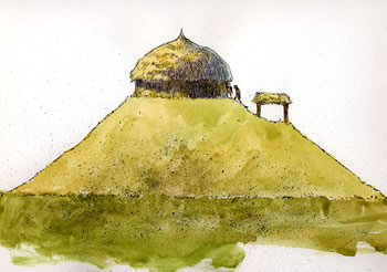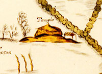
Temple mound, as shown in the Teran
expedition map of Upper Nasoni village.
|
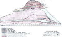
Schematic cross-section (north-south)
through mound.
|
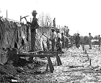
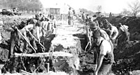
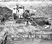
WPA crew excavating through mound.
|
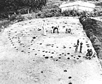
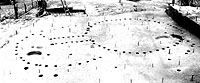
Structural remains of large buildings
on east end of first mound platform.
|
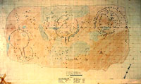
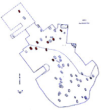
WPA plan of buildings and other features
on first mound platform.
|
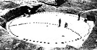
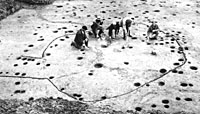
Structural remains on mound platform.
Concentric arcs of postholes represent northern portions
of three large buildings on mound platform.
|
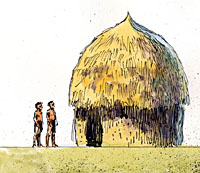
Reconstruction of pre-mound buildings,
as visualized by artist Charles Shaw.
|
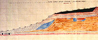
East-west cross-section through middle
of mound showing flat top of original mound and later
addition.
|
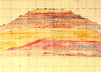
North-south cross-section through
middle of mound showing flat top of original mound.
|
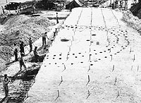
Village excavations by WPA. Work
during this phase was directed by A. M. Woolsey.
|
Large village excavation by WPA.
|
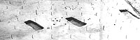
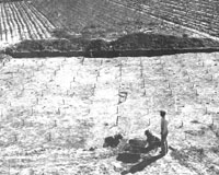
Small cemetery in village residential
area, with three graves shown following excavation.
|
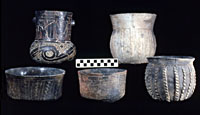
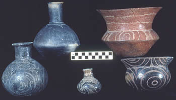
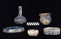
Pottery from early interments.
|
Pottery from early interments.
|
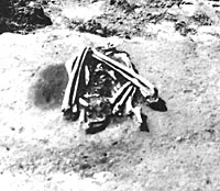
Bald eagle burial uncovered on first
mound platform.
|
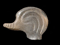
Ceramic duck head from effigy vessel.
|
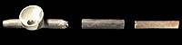
Early style ceramic pipe, Red River
type.
|
|
In 1938, archeologists from the University of
Texas-Works Progress Administration (WPA) project began excavation
on a massive mound on the East Texas farm of Mr. and Mrs.
A.J. Hatchel. The couple were accustomed to living in the
looming shadow of the mound, but they were curious about its
derivation—it was clearly a man-made structure, its age
and purpose unknown.
Several years previously, pioneer Texas archeologist
A.T. Jackson of UT had visited the site and conducted test
excavations on the Hatchel mound. He also investigated one of the mounds atd tdhe Eli Moores site, as well as graves
that had been disturbed during levee construction on the nearby
Mitchell site; during the course of his work, he uncovered
four more graves in the yard area of the Mitchell farm. In
the next year, 21 more graves were excavated by other individuals.
Other Caddo sites, such as the Foster site in Southwest Arkansas, contained mounds with numerous
graves, and these locales were thought to be special cemeteries.
While there had been no indications of interments in the Hatchel
mound, it was nonetheless becoming clear that the Hatchel-Mitchell
area held the potential to be one of the largest and most
significant Caddo archeological sites in Texas.
For the WPA investigators, the task was daunting,
but the crews were willing and numerous at a time when jobs
were scarce. Leading the fieldwork were William C. Beatty,
Jr., Glenn Martin, Arthur M. Woolsey, and Alden Hayes. Initial
focus was on the mound area although, during the yearlong
venture, the crews excavated broad areas in the village and cemetery areas adjacent to the mound
as well.
As workers painstakingly excavated through the
center of the mound, its complex anatomy became more apparent.
At least eight superimposed occupational surfaces (labeled A-H)—each
showing signs of structures, other features, and occupational
debris—were visible as discrete layers in the deep trench
profiles. These occupational surfaces were constructed atop a primary platform (labeled I and J); the mound stood 7.7 m in height and had ramps leading down to the plaza and village. As excavators continued digging, they found four
graves and a pit where two bald eagles had been interred.
Finally, below the mound—on what was termed
the "pre-mound" surface (labeled K)—investigators found
the outline of a large circular structure that had been constructed prior to ca. A.D. 1300. The mound itself began to be built around A.D. 1500 and continued in use until ca. A.D. 1691. In the months-long
process, they had combed through layer after layer of history,
documenting what proved to be an astonishing chronicle of
the mound's creation.
Sometime before A.D. 1300, the inhabitants
of a village at the Great Bend of the Red River built a least
one large thatch-covered structure. How the structure was
used is unknown, but we know it was built at what was then
the natural ground level. After some 200 years, that structure and other remains were covered
over by the erection of the first mound platform. The classic
Caddo mound-building tradition—with attendant pageantry
and customs—was in full sway. In the centuries to come,
other mound-building episodes with new temple structures were to follow—fully eight
in all, based on the layers in the mound fill observed by
investigators.
Given the size of the mound—about 200 feet
long by 145 feet wide and eventually reaching as high as 25
feet—the labor involved in each construction episode must have been staggering. Basket load after basket load of dirt was carried in by the villagers until, finally, a sufficient height was reached for the community�s purposes. For the initial mound platform, this may have been about 13 feet in height. Once completed, the mound was leveled off in preparation for the next step: the erection of one or more large circular, bee-hive-shaped structures in the ca. 11-12 feet of occupation surfaces on the second mound platform. With low vertical sides, the buildings appeared to have a separate pitched roof, unlike those at other mound sites such as the Davis site.
These special structures were used for an unknown
period of time—perhaps as the dwelling and ceremonial
places of a special religious leader. Then, the evidence tells
us, these structures were burned. Some speculate that the
firing of the special structures marked the death of the individuals
who used them, perhaps chiefs or religious leaders. But once
the structures had been burned, the rebuilding process began
anew, and the cycle was repeated —at least seven times—
as structures were built, fired, mounded over, and then renewed
again. Over time, the proportions of the mound reached enormous
heights. The mound in the Upper Nasoni village, marked as
"Temple" on the Teran expedition map was described
by European explorers as dominating the landscape like a small
hill.
WPA excavators also investigated remains of several village areas of the Upper Nasoni. Adjacent to the mound, workers uncovered remains of dwellings as well as several interments that were contemporaneous with mound construction episodes; one village area has been shown by more recent work at the Hatchel site to date as early as A.D. 1040. At the nearby Mitchell site, workers found 50 graves, along with midden deposits and the possible remnants of a large structure. Although archeologists also found the graves of four individuals within the Hatchel mound fill, it was not believed to be a burial mound, but, rather, a temple mound
Archeological evidence generated by the WPA
excavations showed an almost 650-year occupation at the site.
An array of materials provides a glimpse of Caddo lifeways—both
on a day-to-day basis as well as in ceremony. Among the artifacts
are artfully decorated vessels—the trappings of rituals
and burial offerings—as well as more utilitarian pottery jars,
such as those that might have been used to cook simple corn
and bean stews. Ornate jewelry of bone and shell as well as
ceramic pipes were found, along with the more-mundane chipped
stone and pottery tools needed for hunting and farming and
domestic life: arrowpoints and adzes, the milling stones used
by the Caddo women to grind corn and nuts, spindle whorls
and pottery smoothing pebbles, each with a simple beauty all
its own.
Among the pottery remains, 68 whole or partial vessels were recovered, along with more than 15,000 pottery sherds. In studying and sequencing their shapes and design motifs, archeologists have been able to develop a chronological pottery style sequence for post-A.D. 1500 Caddo periods in the local area. The full collection of artifacts and documents from the Hatchel-Mitchell-Moores complex investigations have been analyzed, including the many identified structures.
The photos and maps shown here are from the
1938 WPA investigations; these are housed, along with associated
field notes and documents, at TARL. Only a few of the artifacts
recovered are displayed here although one day we hope to add
an expanded gallery of these fascinating objects, as well as
additional sections on the archeology and history of the Upper
Nasoni village.
Temple on top of mound (side view) circa 1690, as drawn by artist Charles Shaw.
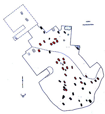
Map of 41BW4, Mitchell site, disturbed
(red) and undisturbed (blue) graves.
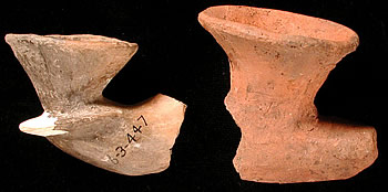
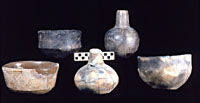
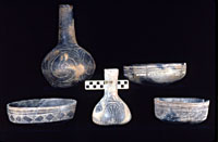
Late pottery.
Late pottery.
Late style ceramic pipes.
|
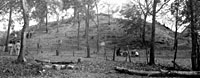
Mound at beginning of WPA excavations.
Structures on top of mound and at right are contemporary
barns and outbuildings for animals.
Click images to enlarge
|
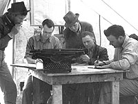
WPA excavation supervisors hard at
work on record keeping.
|
WPA crew excavating upper portion
of mound.
|
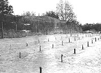
Lengthwise cross-section showing
different mound levels. Wooden grid stakes are laid
out to mark the excavation units.
|
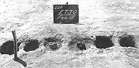
Burned stubs of posts in entryway
of building on mound platform.
|
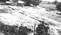
WPA trenches to pre-mound surface.
|
Plan of WPA excavations to pre-mound
surface.
|
Remains of very large building, with
arc-shaped internal partition, beneath west end of mound.
|
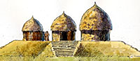
Reconstruction of buildings on first
mound platform by artist Charles Shaw. Unlike structures
at sites such as Davis, the buildings atop the Hatchel
mound had low vertical walls with pitched roofs apparently
attached separately.
|
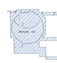
Restricted access building on first
mound platform. Circle of postholes on left may be a
wall enclosing the entrance to a special structure.
|
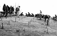
WPA crew at work on village excavations.
|
Structural postholes in residential
areas being examined by WPA crew. Postholes probably
represent one or more buildings as well as remadas for
shelter, and elevated granaries.
|
Early interments at Mitchell site.
The cemetery was in one of the village residential areas
occupied over many generations.
|
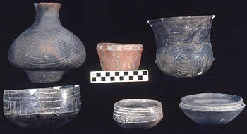
Pottery from middle group of interments.
|
Pottery from middle group of interments.
|
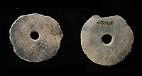
Pottery disks, possibly used as spindle
whorls.
|
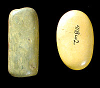
Pottery smoothing pebbles.
|
|