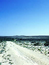
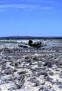
View of the Rustler Hills across
the Great Gypsum Plain.
|
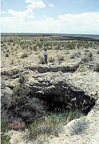
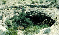
The entrance to Granado Cave is a
sinkhole or circular depression that opens near the
top of a low hill. The sinkhole and the solution cavity
that forms the cave proper are characteristic of a karst
landscape. Shown at the rim of the cave opening is the
author's daughter, Amy Hamilton.
|
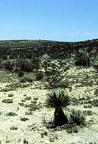
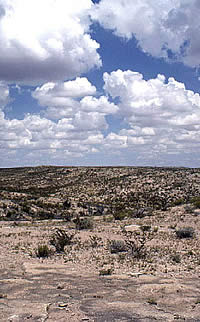
Typical local vegetation includes
yucca, creosote and cactus. The cave is located at the
center of the picture on top of the low hill in the
background horizon.
|
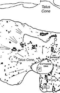
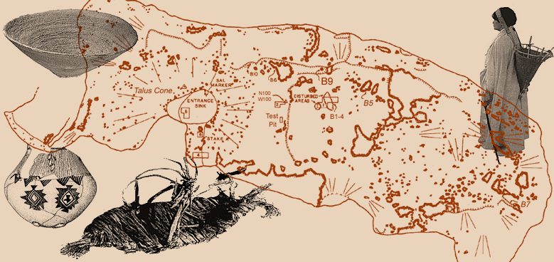
A portion of the site map and profile
of Granado Cave. Click to see the full image.
|

View of one of the site's three ring
middens. A ring midden is a donut-shaped pile of burned
(fire-cracked) rocks with a central depression. Ring
middens represent plant-baking pits surrounded by discarded
cooking rocks. It is hard to make out in this photo,
but the depression is the bare area just to the left
of the center of the picture. The ring of rocks is clearly
visible in the lower right.
|
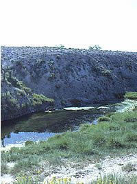
A spring on Two Mill Draw forms a
nice-looking pool of water. Unfortunately, the water
is so heavily laden with minerals that it tastes foul
and is considered undrinkable today. The prehistoric
peoples of the Rustler Hills obviously learned to drink
it, but it gave them diarrhea. They may have consumed
a local plant known as Morman tea to help remedy the
dietary problems caused by the water.
|
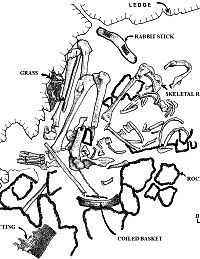
Plan drawing of one of the burials
in Granado Cave, that of a 30+-year-old female suffering
from periodontal disease and arthritis. Some of the
materials found in the grave, such as fragments of basketry
and matting, may have been brought in by a pack rat.
(From Hamilton 2001, Fig. 38.)
|
|
In the rugged Rustler Hills of far west Texas,
a small cave has provided poignant insights into prehistoric
family life. For more than 1200 years, small groups of hunters
and gatherers visited Granado Cave, some making a temporary,
or seasonal, home there. They left behind a wealth of evidence
about their day to day lives: fragments of meals, cooking
"appliances," tools, mats and basketry. They also
left haunting reminders of tragic events long ago—the
deaths of loved ones.
Judging from the burials in the cave, children,
in particular, were accorded special attention in death. They
were carefully covered by, or placed within, ritually "killed"
woven bags and baskets containing fascinating offerings—a
special rattlesnake rattle, a set of deer-hoof "tinklers,"
even the skin of a large bird head (probably a goose).
For archeologists, Granado Cave provides a
window into the past and small glimpses of innovative and
caring peoples trying to make a living in this harsh desert
area. The cave's protective shelter and the region's dry climate
have preserved fragile artifacts and other remains of prehistoric
life that would not have survived in most other areas of the
state.
Setting
Granado Cave is in the northeastern part of
the Trans-Pecos region in eastern Culbertson County, about
halfway between El Paso and Midland, Texas. This region forms
the northeastern corner of the vast Chihuahuan Desert,
North America's largest desert. Vegetation in the area is
extremely sparse, as less than 12 inches (30 centimeters)
of rain falls in an average year.
The cave is located on the western edge of
the Ruster Hills, a chain of low hills that
runs north to south between the Guadalupe and Delaware Mountains
to the west and the Pecos River to the east. Flanking the
Rustler Hills on the west is the Great Gypsum Plain,
a desolate stretch with little vegetation and almost no
surface water. The only waterholes near the cave are along
draws where rainwater occasionally and briefly drains and
where a few springs can be found. Unfortunately, the heavily
mineral-laden water is all but undrinkable. The prehistoric
peoples who lived in the Rustler Hills obviously learned to
drink the water and, judging from evidence in the cave, suffered
the consequences—habitual diarrhea.
The Rustler Hills are the eroded remnants of
a dolomite (magnesium-rich limestone) geological formation
that overlies the thick layers of gypsum, anhydrite, and sulfur
that form the Great Gypsum Plain. This pockmarked terrain
is known as a karst region. Through the eons,
rainwater percolated through cracks and fissures in the porous
rock and mineral layers forming solution cavities ("caves")
and sinkholes.
Site
The Granado Cave archeological site consists
of the cave itself, the opening or entrance area, and a variety
of cultural features that surround the entrance. The cave
proper is a solution cavity that extends for over 200 feet
(about 60 meters) beyond the cave opening. The entrance to
Granado Cave is a sinkhole or circular depression that opens
near the top of a hill.
Most of the sinkhole is filled with natural
and human debris: a "talus" cone made up of the
collapsed dolomite bedrock that formed the opening along with
tons of fist-sized fire-cracked ("burned") dolomite
rocks. The burned rocks are evidence of prehistoric
cooking. Prehistoric cooks found that the sinkhole provided
a convenient windbreak and partially sheltered place for baking
plants such as agave lechugilla. To cook this semi-succulent
desert plant, prehistoric peoples used layered arrangements
of hot rocks and earth that archeologists call earth
ovens.
Most of the interior of the cave is quite dark
even on a bright, sunny day. Thus it is no surprise that the
occupational debris is confined to what the archeologists
called the anteroom, the area just within
the opening where there is enough daylight to see what you
are doing.
Outside the mouth of Granado Cave are a series
of cultural features or activity areas used by the cave inhabitants.
The most prominent outside features are three ring
middens, donut-shaped baking pits ringed by mounded
accumulations of burned rocks. Nearby are three bedrock
mortars, small circular holes in the dolomite that
were probably used for pulverizing seeds or other plant foods.
Prehistoric toolmakers knapped stones into tools nearby, leaving
behind a thin scatter of tool-making debris surrounding the
entrance to the cave.
A total of ten prehistoric human burials
were found in Granado Cave. These included at least five infants
or children and five adults. Most of the graves included associated
material probably representing offerings. Some of the skeletons
show evidence of pathologies—bone damage caused by disease,
accidents, or dietary stress. All of the burials except one
were located fairly near the entrance of the cave. The other
was placed in almost total darkness at the far eastern end
of the cave,
Castile Culture
The native peoples who visited Granado Cave
and other sites in the Rustler Hills can be called simply
the Rustler Hills people or, more formally,
the Castile culture (or phase). The relationship between the
local inhabitants who lived here 450-1800 years ago and the
Indian groups who lived in the region in early historic times
(16th and 17th centuries) is not clear. The historically known
groups include the Manso, Suma, and Jumano tribes. The Granado
Cave research indicates that the original occupants of the
Rustler Hills were a remnant group who may have spoken a language
unrelated to the historically known groups. Researchers suspect
that the Rustler Hills people were pushed into this harsh
and uninviting environment by surrounding groups of people
who were more numerous and lived in more favorable localities.
As a result of the work at Granado Cave, the
Castile phase or culture
has been defined to describe a hunting and gathering culture,
with distinctive artifacts and lifeways, that occupied the
Great Gypsum Plain and Rustler Hills from at least A.D. 200
to about A.D. 1450. Their economy was based on a narrow range
of plant foods, including grasses, lechugilla, sotol, mesquite,
and various cacti. Rabbits, rodents, and small reptiles were
a regular part of the diet. Deer and antelope were hunted,
but these larger and more desirable prey animals were rarely
available.
Artifacts distinctive to this culture include
the Rustler Hills Kiâhâ, a type
of carrying basket, and the Rustler Hills Twined Grass
Bag, made of large coils of retted grass. Also present
are distinctive parching baskets and twilled sotol leaf mats.
Fishtail sandals made of narrow-leaf yucca
appear to have been worn primarily by children. These appear
to be the only type of sandals found in this culture phase.
Both cotton cordage and woven cotton were used by the Castile
culture. The presence of Southwestern pottery at the cave
speaks to trade contacts with people to the north and northwest.
|
The entrance to Granado Cave.
Click images to enlarge
|
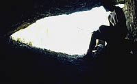
Looking out of the cave from the
anteroom.
|
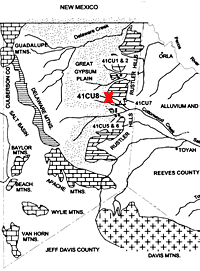
Map of Culbertson County and vicinity
showing the Rustler Hills, the Great Gypsum Plain, and
other landscape features in the area. The red X marks
the location of Granado Cave, also known as site 41CU8.
The approximate locations of several other archeological
sites in the Rustler Hills are also shown. (Adapted
from Hamilton 2001, Figure 2.1.)
|
View across the top of the hill within
which Granado Cave is located. The rock formation visible
in the foreground is dolomite or magnesium limestone.
|
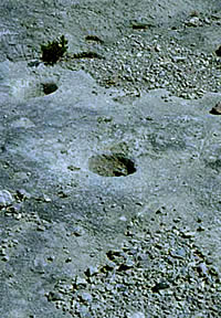
Three bedrock mortars found outside
Granado Cave were used by the inhabitants to prepare
food.
|
Granado Cave's nearest water source
is Two Mill Draw, almost two miles (3 kilometers) north
of the site.
|
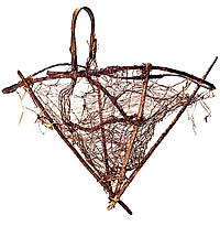
A large carrying basket found ceremonially
"killed" over Burial 1.
|
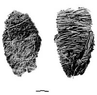
Bottom and top surfaces of two Yucca
elata sandals worn by a child.
|
|