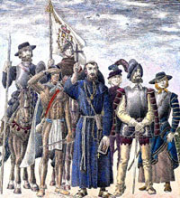
During the 16th century, El Paso became an important stop for Spanish explorers on their way to New Mexico to find riches and convert the native population to Christianity. After the founding of Santa Fe in 1609, El Paso became a critical point in the long north-south route of communication and trade between the Mexican interior and the missions and Spanish settlements of New Mexico. Painting by Jose Cisneros, courtesy of the University of Texas at El Paso Library Collection.  |
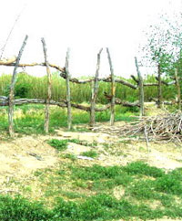
A traditional log fence, secured with thin willow branches, encloses a field in San Elizario, Texas. Site of an 18th-century mission and presidio, the small community still retains its Spanish Colonial flavor. Photograph by Susan Dial. |
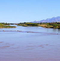
The Rio Grande above El Paso. Before the construction of the Elephant Butte dam near Truth or Consequences, New Mexico, the Rio Grande was unpredictable, prone to flooding, drought and channel-switching. Irrigation canals were necessary for agriculture in El Paso and to help dissipate floodwaters from the Rio Grande. Photograph by Susan Dial. |
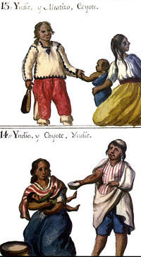
Coyote and Indio castas as depicted by O'Crouley in 1774. These paintings reflected the social status, or casta classifications, of individuals of various ethnicities in New Spain, with "Espańol" being the highest rank, according to officials and priests. In El Paso, the categorizations may not have been as rigid as in some other areas. |
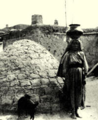
Nestora Piarote Granillo, a Tigua potter, stands next to a "horno" in the Old Ysleta Pueblo, circa 1876. Hornos are used to bake wheat bread and were introduced to the Americas along with wheat by the Spanish. |
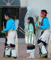
Tigua social dance following Novena mass. Of all the known native groups who called El Paso home during the 17th, 18th, and 19th centuries, only the Tiguas have maintained their cultural identity. Photograph by Al Baeza. |
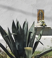
A white-washed adobe building with small shrine to the Virgin of Guadalupe provides the backdrop for a large agave plant in San Elizario. Photo by Susan Dial. |
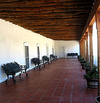
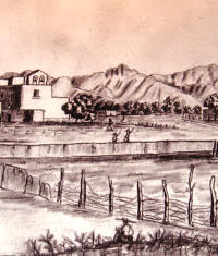
The shady gallery (portal) at Los Portales Cultural Center in San Elizario beckons visitors. Housed in one of the oldest buildings in the village—a territorial style adobe residence dating to the 1850s—the center offers a series of informative displays on area history. Photo by Susan Dial. |
|
El Paso lies at the far western tip of Trans-Pecos Texas, where the Rio Grande breaks through the rugged mountains to bring water to the harsh Chihuahuan Desert. Though the surrounding landscape is dominated by desert scrub growth on the low hills and mountain sides, the river valley is a fertile alluvial plain supporting a variety of trees and plants. This dramatic landscape is the stage for the story of the missions and settlements of the El Paso valley and its evolution into one of the most productive agricultural areas in the region during the Spanish reign.
In historical parlance, “El Paso” encompasses the area that includes the present-day cities of El Paso and Juárez and the small communities of Ysleta, Socorro and San Elizario. Before the arrival of the Spanish, El Paso had been inhabited for thousands of years by Native Americans. During the 16th century, it became an important stop for Spanish explorers on their way to New Mexico to find riches and convert the native population to Christianity. In 1583, Spanish explorer Antonio de Espejo described El Paso as having very good land and climate, with buffalo herds nearby, abundant game and birds, mineral deposits, many forests and pasture lands, rich natural deposits of salt, and abundant water in large marshes and pools.
For the Ońate entrada, "El Paso del Río del Norte,” was the much sought after pass through the mountains that the expedition needed to enter the province of New Mexico. After the founding of Santa Fe in 1609, El Paso became a critical point in the long north-south route of communication and trade between the Mexican interior and the missions and Spanish settlements of New Mexico—the Camino Real.
The story of the missions of El Paso is quite different from that of other Spanish missions. Unlike the more well-known missions of South Texas, only three in the El Paso area were founded in an attempt to “settle” the native people of the area. The rest were founded for the refugees and hostages from the 1680 Pueblo Revolt in New Mexico, native people who had already been “missionized,” or acculturated, by the Spanish. The Puebloans from the north also brought their own traditions with them, including farming skills developed over hundreds of years. Caught between two worlds, these Indians were alternately hostile to and accommodating to the Spanish. Although they were “Christian Indians,” they maintained a unique and separate lifestyle for some time.
Over time, El Paso was home to Mansos, Piros, Janos, Sumas, Tanos, Tiguas, Tompiros, Apaches and Jumanos, as well as many more ancient groups whose names have been lost to history. Descendants of some of these diverse ethnic groups survived into the late 19th century and were interviewed by Southwest historian and archeologist Adolph Bandelier. With few exceptions, all had forgotten their native languages and had lost track of their tribal identity following years of living with other groups and speaking chiefly Spanish. Today only the Tiguas remain as an organized group, although their official status and rights to their land have been a matter of contention. In 1967, the State of Texas recognized the Tigua as a Texas Indian tribe; at that time, there were roughly 100 Tigua families living in Ysleta. It was only in 1987 that they received federal recognition as an American Indian Tribe.
Were we to ignore the Indian viewpoint, there are a succession of historical “firsts” in the El Paso valley: celebration of the first “Thanksgiving,” first production of a literary play in North America, and establishment of what would later be considered the first mission in Texas. Over time, the valley saw dramatic change, both in the cultural and physical world. The area’s original inhabitants—peaceful hunter-gatherers who roamed throughout the valley and traded their pottery and goods across the desert Southwest—fell victim to disease and warfare brought by the Spanish as well as more hostile Plains Indians from the north. Their traditional way of life was replaced by the Spanish system of government, economy, and religion.
Connected by a vital trade route to Spanish towns to the north and south and located in a prime area for farming and trade, El Paso became a thriving center with a diverse mix of people. As Pedro Alonso O’Crouley described life around the presidio at El Paso del Norte in 1774:
There is a large population of Spaniards and mestizos because it is on the border of New Mexico, where fairs are held, horses traded, and horsehides, cured sheepskins, buffalo robes, and the like are bought and sold. It is also here that captives who have been ransomed from the heathen tribes are sheltered and instructed in the mysteries of the faith.
The Rio Grande itself, the life-blood of the valley, also wrought change. Floods repeatedly washed away agricultural fields and destroyed buildings and settlements, forcing the Spanish and Indian laborers to repeatedly reconstruct them or move them to new locations. Progressively moving southwestward from its established channel, the river changed course repeatedly, ultimately leaving the missions, native pueblos, and small Spanish communities on its opposite side—the north bank—in territory that would ultimately become Texas. The coming of the railroads and an influx of Anglo travelers and settlers brought widespread political changes that would again alter the lives of El Paso valley people.
Although the city of El Paso today is an industrialized center with population well over 650,000, the villages along the river valley to the south still maintain vestiges of their Spanish Colonial and native roots, along with modern innovations, and are among the oldest continuously occupied communities in the Southwest. The Tigua pueblo at Ysleta is still ruled by a tribal government headed by the cacique and his captains, and maintains a cultural center as well as a casino. Three of the Spanish Colonial churches, all reconstructed, hold Catholic services and are vital centers of their communities. Here ceremonies blending native and Spanish traditions, song, and dance are played out—a fragile thread to the past.
As in the past, the river binds and sustains these communities. Fields of cotton and groves of pecan trees have taken the place of crops of earlier times: wheat, corn, and grapes. Farmers still irrigate their fields with water drawn from a system of riegos, or canals, diverting water from the river. A U.S. Army base, Fort Bliss, stretches east and north of El Paso. Like its Spanish predecessors, this fort was established to protect settlers from attacks by Comanche and other hostile native groups. Today, its concerns are more global.
The following sections use historical maps and documents, archeological research, and archival photographs to tell the story of the missions and settlements of El Paso. History of the El Paso Valley explores the 400 year history of the missions and Spanish settlements of El Paso, with particular emphasis on the lives of their Native American inhabitants. Investigations at the Old Socorro Mission examines findings from archeological investigations and mortuary analysis at the Old Socorro Mission, a mission occupied by Piros and mestizos from 1684 until 1740. Excavations at the Ysleta Jacal Site examines findings from archeological investigations at the site of an historic Tigua settlement. Teachers: Oldest Mission in Texas consists of a lesson plan that guides teachers in conveying an understanding of Spanish settlement in the El Paso Valley. Kids can explore maps of the El Paso Valley as it looked 250 years ago in Kids: Mapping the Past. Credits and Sources acknowledges authors and provides a list of references and resources for further information.
(To learn more about the Tigua and other historic native groups, see the Native Peoples section.) |
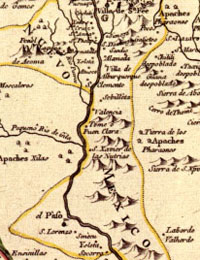
Map of New Spain, 1768, with New Mexico (including the El Paso valley) encircled in gold and Provincia de los Tejas on right. After the Pueblo Revolt of 1680, a large number of Tigua, Piro, Tompiro, Tano, and Jemez refugees and hostages accompanied the Spanish south to El Paso where Governor Otermín founded the missions of Corpus Christi de la Ysleta, San Antonio de Senecú, and Nuestra Seńora de la Limpia Conceptión del Socorro for them. “Nueva Mapa Geographico de la America Septentrional” was drawn by Mexican cleric and scientist, José Antonio de Alzate y Ramirez. View larger versions. |
Sketch of Ysleta Pueblo, drawn by a Confederate soldier in 1862, purported to be the oldest image of the pueblo and mission. Ysleta del Sur, as it was called, was originally built for Tigua Indians who came to El Paso in 1680. The image is part of a display in the Tigua Cultural Center in Ysleta, south of El Paso. |
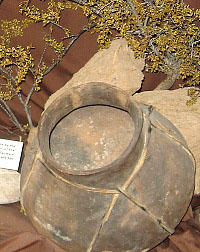
Display of native pottery in the Tigua Cultural Center in Ysleta, one of the original settlements south of present-day El Paso. Text in the display reads: Large ceramic pots or ollas were made by the Tigua and other neighboring Indians of the region (Manos and Piro). These large ollas were made by the Manso Indians at San Jose and San Lorenzo in Ciudad Juarez. Archeologists and other researchers working in the area have used ceramics from excavated sites to trace cultural traditions and amalgamation. Photograph by Susan Dial. |
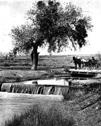
This irrigation canal, photographed by Thomas K. Dodsen in 1907, is likely very similar to those used in El Paso throughout the 18th and 19th centuries. During his visit to El Paso in 1760, Bishop Don Pedro Tamarón y Romeral described “a large irrigation ditch with which they bleed the Rio del Norte. It is large enough to receive half its waters. This ditch is subdivided into others which run through broad plains, irrigating them.” Note adobe building in background. |
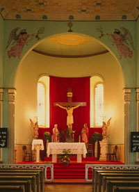
Interior of Catholic church at San Elizario, Texas. Photo by David Kaminsky, Historic American Buildings Survey, courtesy of Library of Congress. |
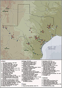
Map of Spanish Texas, with locations of missions, presidios, and settlements. Note that the first mission established in the area, San Antonio de Senecu, lies in what is today the city of Juarez. Map by Bruce Moses. Courtesy of the Center for Archeological Research, University of Texas at San Antonio. |
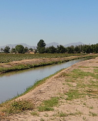
Irrigation canals, drawing water from the Rio Grande, runs alongside agricultural fields in the El Paso valley, just as in earlier times. Cotton and pecans are among the major crops today. Photo by Susan Dial. |
|