Understanding the Historic Farmstead Landscape
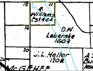
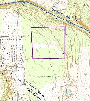
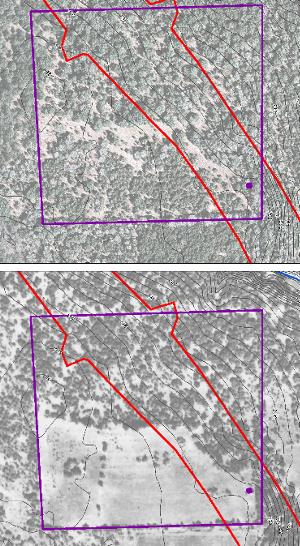
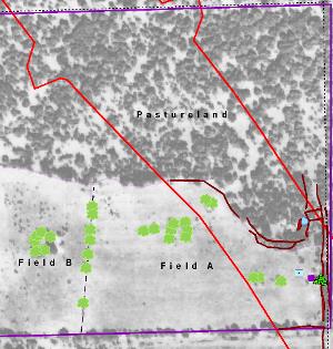
The examination of the Williams farm system began with a comprehensive landscape analysis focusing on the 45-acre farm and its relationships to the surrounding areas. This work involved many different tasks: gathering historic and modern aerial photographs and maps; mapping of onsite features (e.g., rock alignments, remnants of barbed wire and wooden fences, rock mounds) and landscape topography at different levels using GPS equipment and an electronic total station; pedestrian survey and collection of surface artifacts; metal detector surveying and documentation of metal detected artifacts; mapping of very large hardwood trees and documentation of tree features; and backhoe trenching to investigate rock walls and a possible pond location. The onsite investigations were limited to the portion of the site located within the state-owned right of way, but the entire 45-acre property and surrounding areas were examined using the historic and modern aerial photographs and maps. One of the main results of this landscape analysis was the creation of an integrated GeoPDF file that consists of many layers of spatial data linked to real-world coordinates. Each aerial image or map layer was georectified to the same UTM coordinate system, which allowed the PAI archeologists to overlay and display different types of data in many visual formats to look at spatial relationships between variables. As it turns out, the spatial patterns discovered in this manner are quite meaningful and reveal a great deal about the history and evolution of the Williams farmstead. Knowing where the 45-acre farmstead is located was the starting point for the landscape study. The first step was to rectify the old historic maps and aerial photographs with modern maps and aerial images. We began with the 1874 plat map that showed the subdivision of a portion of the John G. McGehee League into 40-acre tracts. Once this map was linked with modern Travis County Appraisal District maps, it was then easy to transfer the location of Williams' Lot No. 11 onto various modern maps. The correspondence between maps was not perfect, and some adjustment had to be made for the additional 5 acres, but it soon became apparent our link between the old and new maps was solid. Once this was established, we could look at the location of Williams' 45-acre property, including his house and all the other features on the land, in relation to all types of old and modern spatial imagery. As shown on the U.S. Geological Survey map, Williams’ property is located on the uplands south of Bear Creek. Because there was no stream on his property, water would be a precious resource on his land. It is also notable that the south and west half of the property is relatively flat while the north and east portions have a significant slope. The slope of the land was an important factor dictating how Ransom Williams would use his property. The base map is the 1988 Oak Hill Quadrangle by the U.S. Geological Survey, and there has been considerably more development in the area since the 1980s. A comparison of aerial photographs of the Williams property in 1937 and in 2005 shows how the land has changed over time. (Topographic lines at 2-ft intervals have been added to both images.) The 2005 photo (top half) shows how the property looked about the time the historic research on the farmstead was beginning. The area was densely wooded and a large housing subdivision was located to the west. In 1937, the 45-acre property looked quite different. Some cultivated fields are obvious in the old photo, while roads and fencelines are visible as lines of cleared vegetation found along property boundary edges. It is notable that the southern half of the property was being cultivated in 1937 while the northern half of the property was left wooded. There is considerable evidence indicating that this was the way that Ransom Williams originally laid out his farm. Once all of the landscape mapping data were compiled and analyzed, a picture of the layout of Williams’ 45-acre farm emerged (see aerial map with features plotted). Topographically, the location made perfect sense to incorporate the maximum drainage area for channeling rainfall into the livestock pond. The house location was judiciously selected because it was on the east side of the cultivated fields, where the family could watch over the fields and plant a garden nearby, but it was still fairly close to the corral complex and the livestock pond. At the time the Williams family lived on the farm, access to and across the property was probably along a north-south road along the east edge of the property. It is likely that Ransom Williams would have gone off his property in the northeast corner and followed an old road to the north or east to go down to Bear Creek. There are many components that would be considered typical of late nineteenth-century rural farms and ranches that are not shown on this map, but this does not mean that they did not exist. Some important features that probably existed on the Williams farmstead were not found. Examples of these types of features include a chicken coop, pig pens, cow barn, fenced garden, corncrib, hay shed, and smokehouse. The oral history interviews are filled with peoples’ recollections of raising corn, cotton, hay, garden vegetables, chickens, pigs, and hogs, as well as mentions of livestock barns, chicken pens, pig pens, hay and corn sheds, and smokehouses. Once the above-ground structures are gone, these types of features are nearly invisible archeologically, so it is not surprising that we found no evidence of them. But the farmstead did yield lots of evidence that hints at the existence of many of these features. We found bones of chickens, pigs, and cows, a garden hoe, charred corn kernels, and a patented hand-sheller for removing kernels from corncobs. When taken together, the oral history and archeological evidence suggest that the farm had a smokehouse and other structures to house animals and store hay and corn. The oral histories also mention vegetable gardens and orchards, and charred fragments of sweet potato and peach pits were found on the Williams farmstead. |
|