University of Texas at Austin wordmarkCollege of Liberal Arts wordmark
Texas Beyond History
TBH Home
Plains Villagers Main
photo of Wolf Creek Valley
Wolf Creek Valley was densely settled by Plains Villagers between about A.D. 1200-1400. This shot was taken during the 1987 field school of the Texas Archeolgical Society. Work is in progress on a Buried City house designated as Courson A. Photo by Madeline Jeffress.

In Ochiltree County, Texas, on the south bank of Wolf Creek, is a group of stone ruins which has aroused the interest and curiosity of all who have visited them, and caused much speculation among those who have tried to formulate a theory to account for their existence. It is a firmly established opinion of many who live in the vicinity that the place where these ruins are was at one time the site of a prehistoric town. This opinion was deduced largely from the fact that the remains resemble to a marked degree the foundations of large buildings. … The place has long been known as "The Buried City."

T. L. Eyerly, Canadian, Texas, 1907.

 
photo of Wolf Creek
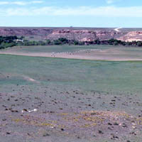
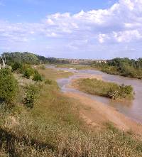
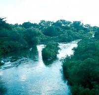
Wolf Creek in the northeast corner of the Texas Panhandle is a permanent stream fed by the Ogallala formation. It flows east into Oklahoma and then swings northeast to join the North Canadian River, one of the major tributaries of the Arkansas River system. For the Buried City people, the Wolf Creek Valley was a well-watered and thickly wooded oasis amid the dry grassy sea of the High Plains. Photo by David Hughes.

Click images to enlarge

aerial photo of Wolf Creek Valley
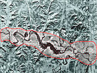
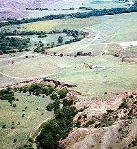
Aerial photograph taken in 1937 of the Wolf Creek Valley highlighting the dense Buried City settlement zone. Stone-based structures are distributed along the terraces of this valley every 80 to 150 meters (87 to 163 yards) and are clustered in small villages or hamlets. Graphic by David Hughes.

The "Buried City" of the Texas Panhandle is not, in fact, the remains of a city, but it is one of the most densely settled archeological districts in the Southern Plains. Packed into a few short miles of narrow Wolf Creek valley are more than 100 known habitation sites with the remains of houses mainly built by Plains Villagers between about A.D. 1200 to A.D. 1400. It is very likely that many other less-obvious (and perhaps earlier) pithouses lie buried within the Wolf Creek Valley. Buried City or not, the name has stuck and can refer both to the settlement zone along Wolf Creek and to the Plains Village culture that called this place home 700 years ago.

Since the 1920s Buried City has been equated with one or another surrounding prehistoric cultures including the Pueblo "Cliff Dwellers" of the American Southwest, the Antelope Creek villagers of the Canadian River, and the Woodland "Mound Builders" of the Kansas City area and points further east. Today the facts, as we see them, don't fit any of these notions. Instead, investigations over the past two decades have shown that Buried City was part of a distinct culture of its own, one of a growing number of variations on the Plains Village theme that archeologists now recognize.

The people of the Buried City practiced horticulture, a form of low-intensity gardening that led to full-scale agriculture in other areas. They grew corn and probably squash, beans, and other crops. But they were also buffalo hunters and hunters of deer and other game. And they harvested wild fruits, seeds, flowers, and other plant foods. For more than three centuries, people lived, worked, planted, and harvested crops, hunted, and died along this small stretch of Wolf Creek in what is today the Texas Panhandle.

This exhibit summarizes what we now know about the Buried City and the villagers who lived there. Below is an introduction to the natural setting of the Wolf Creek Valley. In other exhibit sections you can learn about the History of Investigations, Buried City Settlement, Buried City Architecture, Traces of Life, Buried City Reconsidered, and Credits and Sources.

map of top of Texas Panhandle
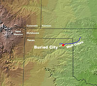
Location of Buried City and Wolf Creek. Base map from NationalAtlas.gov.
photo of "Gould Ruin" excavation
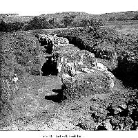
Photograph of Warren K. Moorehead's 1920 excavation of "Gould Ruin" also known as "Eyerly's Temple," the largest structure at Buried City and the only known multi-room building. From Moorehead, 1931.
photo of antelope
Antelope graze on the High Plains near Wolf Creek. Prior to the last century, this vast, level surface was a short-grass prairie dominated by blue grama and buffalo grass. Today irrigated and dry-land farming and oil and gas production have altered the appearance of much of the area. Photo by Steve Black.
photo of expansive cropland
Today much of the High Plains is under cultivation. Photo by Steve Black. 
photo of looming storm clouds
Thunderstorm looms. Most of the rain that falls in the Texas Panhandle typically comes in only a half-dozen torrential thundershowers in the late spring. Photo by Kris Erickson.
photo of Wolf Creek Valley
Wolf Creek Valley. The caprock of the Ogallala geological formation lines the far side of the valley. Water from the porous layers at the base of this formation keep Wolf Creek flowing year-round. Photo by Chris Lintz.

Natural Setting

To understand a people, you need to understand the place where they lived, how they lived, and the limits the natural world imposed upon them. People who first encounter the High Plains of the northern Texas Panhandle today think of it in terms of a boundless expanse of grass, wheat, and cattle. Its most remarkable feature is that it is billiard-table flat: you can see the clump of trees miles before you get close to a modern farmstead. The other striking feature, literally, is the wind. The normal southwest (spring and summer) or northwest (fall and winter) breezes blow at 5 to 15 miles per hour day and night and then there are the windy days when it really howls. To natives of the Panhandle, the more remarkable moments are those rare days when the wind is NOT blowing.

On paper, the annual rainfall of 16 to 20 inches makes the area seem ideal for grain agriculture, but much of that rainfall typically comes in only a half-dozen torrential thundershowers in the late spring. Because the area is dry most of the year, water is a constant concern. On the High Plains the scattered playa lakes (round, natural depressions that formed tens of thousands of years ago) hold some water from the spring rains through much of the summer, but in dry times access to water becomes a problem. The best water available comes from the Pliocene age Ogallala geological formation that forms the caprock of the Texas Panhandle. Depth from the modern surface to the water-bearing part of the Ogallala varies from less than 100 feet to over 200 feet. The major stream valleys have in many instances cut down into the Ogallala, providing access to freshwater springs along the margins of their valleys.

Because of this geography and climate, few prehistoric peoples lived on the high plains. Rather, they lived along the streams that cut across the High Plains, streams like the Canadian River and Wolf Creek. These stream valleys provide access to spring water from the Ogallala, a much wider variety of plants and animals than the short-grass prairies of the High Plains provide, and shelter from the winds. Such places are truly oases on the plains.

Wolf Creek is among the most inviting of these spring-fed riverine retreats on the High Plains. As Eyerly put it in 1907:

aerial photo of playa lakes
Over 19,000 playa lakes occur in the Texas Panhandle. During wet periods they may hold water for months or even years, but most are small in size and dry up completely during droughts. Playa lakes are one of the very few surface water sources in the region. Courtesy Texas Parks and Wildlife.
photo of Canadian River
The Canadian River parallels Wolf Creek about 20-25 miles farther south. Although its valley is much larger and it carries more water, the water of the Canadian River is mineral-laden and not as good to drink as that from Wolf Creek. Photo by Steve Black.
 

The immediate surroundings are very picturesque and pleasing to the eye. Situated in a bend of Wolf Creek, with its abundant supply of crystal waters, and covered at this place with plenty of timber, the site was well fitted to attract with its beauty the hearts of whatever people which may have constructed these walls which now lay in ruins.

 
aerial photo of Buried City settlement
Aerial photograph of main area of Buried City settlement along the winding Wolf Creek. Photo by David Hughes.

Because Wolf Creek flows west to east, its narrow, entrenched valley offers shelter from the prevailing southwest and north winds. In prehistory Wolf Creek was attractive to game of all sorts, the stream contained several varieties of fish and shellfish, and the banks supported dense woods. Although they are all but gone today, the narrow stream-side forests along Wolf Creek and other parallel drainages are the westernmost fingers of the Eastern Woodlands, narrow ribbons that stood in woody contrast to the grassy High Plains.

People probably first visited this idyllic setting during Paleoindian times, although no definitive evidence of this is known. Scattered finds of Archaic artifacts show that people have been spending time along Wolf Creek since at least 6,000 years ago and there is evidence of at least intermittent occupation throughout the remaining prehistoric era. Archeological investigations have focused on the latest of these prehistoric occupants: the Plains villagers of about 600-1000 years ago. These people lived along the banks of Wolf Creek on a year-round basis. They made several kinds of houses including dwellings with stick and post walls built on the unimproved ground surface, small houses built over or in small, shallow pits, and large houses with boulder wall bases and massive central supports. These latter houses are what have lured archeologists into the Wolf Creek valley for the past hundred years. Advances in remote sensing technology have begun to make it feasible to locate and explore the more ephemeral and less obvious houses, of which there are probably a great many.

arrow link to Buried City Investigations

photo of area of Kit Courson house
View of upper section of the Buried City settlement zone along Wolf Creek. The Kit Courson house is visible in the center of the picture. Photo by David Hughes.