Discovery of Hank's House
|
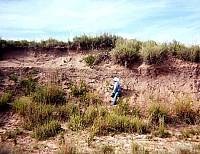
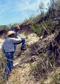
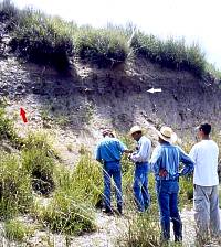
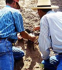
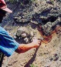
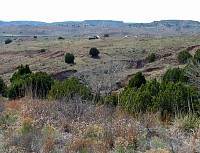
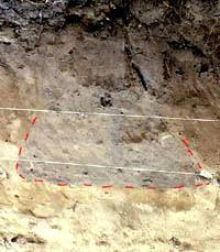
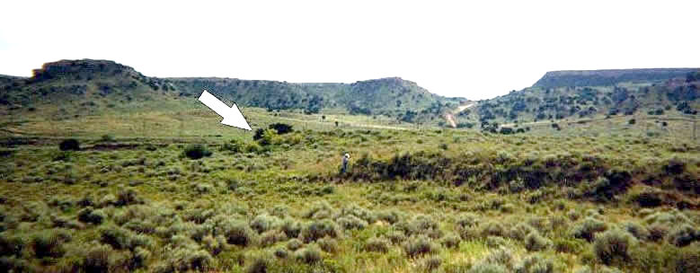
It all started with a horseback ride in the spring of 2000. Rancher John Erickson was out tending cattle when he came across an interesting find. By this time, Erickson knew much about the prehistoric people who had lived in the area where his ranch now stood. He had been bitten by the archeology bug and had trained his keen eyes to search for flint chips, bone fragments, burned caliche rocks, and other clues of long-forgotten peoples. On this particular occasion while riding along a creek bottom, he noticed some black stains buried in the edge of the cutbank. He instinctively knew that it was probably charcoal, or burned wood, and that it might be part of a prehistoric site. He stopped for a moment to investigate. Convinced it was probably worth a closer look at some later time, Erickson went on searching for his cattle but filed away the location of this new find in his mind. A few months later, the "Two Dougs" (Wilkens and Boyd) visited the ranch and Erickson showed us some of the archeological sites he had found. Prior to this trip, Wilkens and Erickson had spent many days recording and investigating sites on the ranch, and Boyd had visited on one other occasion. We knew that there were lots of interesting archeological sites on the ranch, but all three of us were surprised and excited by what we discovered on this particular day—July 16, 2000. Erickson took us back to the creek where he had found the charcoal. It looked interesting, so we began looking closer. Creek cutbanks have a way of hiding buried things, so it took us a few minutes to carefully trowel away the thin layer of rain-washed soil that had already covered the charred patch Erickson had seen before. Once we got a good look at the freshly exposed strata, the extent of the find became obvious. A horizontal line of charcoal could be traced for nearly 20 ft (about 6 meters) along the cutbank. There were masses of burned branches and smaller twigs, along with burned clay lumps (called daub) that had impressions of sticks in them. In the center and just below the charcoal line was a bowl-shaped depression outlined by thick, bright orange burned clay and filled with gray ash and brown sand. The signs were unmistakable—it was the floor of a pithouse and a firepit buried by layers of sand laid down by the stream. Because there was so much charcoal and daub, we speculated that the upper portion of the house had burned, and the wood and clay from the roof had collapsed onto the floor. Because most prehistoric houses in this area have a firepit or hearth right in the center, we realized the creek had sliced this house exactly in two. Such finds are fairly rare, even for archeologists—in just a few minutes we had exposed a prehistoric house sliced in half as neatly as any archeological excavation could have done. In our excitement, the questions flowed quickly: How old was this house? Was it part of a village? What other surprises did the cutbank hold? We spent more time looking along the cutbank near the house and found flint flakes and some sherds of cordmarked pottery. The pottery told us that the house probably belonged to the Plains Woodland or Plains Village peoples who inhabited this stretch of the Canadian River valley between about A.D. 200 and 1450. Because the sherds were fairly thick—thicker than the typical late Borger Cordmarked variety—we suspected that it could be from the Plains Woodland or early Plains Village periods. The thrill of discovery continued as we three explorers found a storage pit, exposed in the same cutbank about 50 feet (15 meters) away from the buried pithouse. The pit, dug into the ground by prehistoric people, was a typical "bell-shaped" storage pit like those used by many Southern Plains villagers. These pits were circular on the top, and, like the Liberty Bell, expanded out into a flat bottom. The excitement wasn't over just yet. As we continued our search farther away from the buried pithouse, we found more evidence of prehistoric occupations. Flint flakes, bone fragments, and pottery sherds were strewn along the cutbank of the meandering stream channel as far as 650 feet (nearly 200 meters) to the west of the buried house. More artifacts and dark stains in the ranch road marked locations of other probable buried houses some 980 feet (nearly 300 meters) to the south. Most of the intervening area had a thick layer of sand dunes that completely covered the alluvial terrace, but these finds indicated that buried cultural deposits could be present over an area of 645,500 square feet (60,000 square meters) or over 13 football fields or more! We returned to Erickson's house for lunch and reported the interesting finds to John's wife, Kris, and son, Mark. The whole group of us then returned to the site and spent much of the afternoon recording archeological details about the new site. As we carefully excavated and bagged a small sample of charcoal from the burned pithouse for radiocarbon dating, we speculated on the possible age of the buried house. Later in the evening as the sun began to sink below the canyon rim at the ranch house, everyone sat on the Erickson's front porch to discuss the day's events. The significance of the day's finds was beginning to sink in. John's sharp eyes and inquisitive mind had led to the discovery of a burned prehistoric pithouse, a relatively rare occurrence. Even more important, the discovery included a whole village site, apparently a large one, in an area where few such sites were known. Only a tiny portion of the site was visible, but it was clear that many other houses and other evidence of prehistoric life remain buried there. Such discoveries do not happen every day. Everything considered, July 16, 2000, was an exciting day for Panhandle archeology. I suggested that this new site be called Hank's site in honor of Hank the Cowdog. The name stuck, and from that point on, everyone referred to the buried pithouse as Hank's house. |
|