Investigations
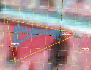
Color infrared aerial photograph showing location of Mission Dolores. The dark red "hot" area on the south side of the road demarks the area where Spanish Colonial artifacts and structural traces are concentrated. The dashed yellow line marks the path of El Camino Real. Graphic by Jeff Williams. |
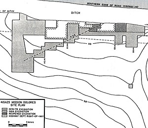
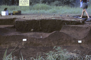
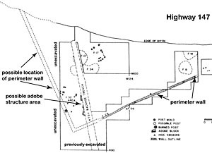
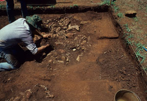
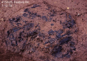
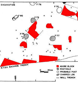
Once the location of the surviving traces of Mission Dolores was finally pinned down in 1976, additional archaeological investigations have been undertaken over the last three decades by several different lead researchers and organizations. Although each field season could be considered on its own, we will review this work in three “phases” led by principal investigators Jim Corbin, Shawn Carlson, and George Avery. Corbin Investigations, 1976-1984The archaeological research carried out by Professor Jim Corbin and his students at Stephen F. Austin University (SFA) has provided the lion's share of the archaeological data from Mission Dolores. Here we discuss what was accomplished in each of Corbin's four field seasons followed by a summary of what Corbin learned. 1976The 1976 field investigations consisted of eight field days by student volunteers from SFA. French faience sherds were observed south of Highway 147 in the cut bank of the highway ditch. Portions of the cut bank of the ditch were examined and several pit features were identified. These pit features were excavated in an area totaling 18 square meters. An area of French artifact concentration was identified and referred to as �The French Area.� The excavations were carried out by volunteers on six Saturdays in 1976 by members of the Nacogdoches Archeological Society, the SFA Archeological Field School, and the Anthropology Club of SFA. These investigations were sufficient to determine that intact archaeological deposits related to Mission Dolores were indeed present south of highway 147. A preliminary report of these investigations can be downloaded in Credits and Sources. 1977The 1977 field investigations at Mission Dolores included a six-week SFA archaeological field school, followed by six more weeks of work funded by the citizens of San Augustine and the San Augustine County Historical Society. The overall strategy was to investigate 3-x-3 meter areas divided into nine 1-x-1 meter excavation units, excavated in 10-cm levels. In addition, three units were excavated west of Kathleen Gilmore�s backhoe trench, and four were excavated in a north south line east of the French Area to better define the limits of the site occupation. All excavations were by hand, with shovel skimming and scraping by trowel being the primary excavations techniques. During the investigations the French Area was expanded, and various archaeological features were documented: four trash pits, a jacal (hut) wall (Feature 25), a well, and the remains of two structures. Gilmore�s backhoe trench was re-opened, expanded, and dug to a greater depth. The well was identified at the north end of Gilmore�s backhoe trench. The 1977 field season was the most extensive of all the field seasons at Mission Dolores, and may have been the most exciting. The $7,000 raised by the City of San Augustine and the San Augustine County Historical Society was well documented in the local papers. 1978Working with student volunteers, Corbin's initial work included three backhoe trenches in the area to the southeast of the previous excavations. Very little cultural material was identified in the backhoe trenches, and excavations focused on expanding in the area of previous excavations. More of the jacal wall (Feature 25) identified in 1977 was exposed. Other features included a small hole that contained a concentration of burned wood and charred corncobs. The function of this feature was not clear. A presumed adobe structure was identified and investigated (Feature 32). It is possible that this structure formed the southwest corner of the mission compound, with two of the walls of the structure serving as perimeter walls as well. A probable portion of El Camino Real de los Tejas (Feature 65) was profiled in the ditch of the modern highway. A preliminary report of the 1976-78 investigations was submitted to the Texas Historical Commission in 1978, and the final report was published in 1980 (see Credits and Sources). 1984The goal for the 1984 field season was to excavate within the highway right-of-way to the edge of the ditch prior to construction along the highway to alleviate the need for the ditch and prevent further erosion. Most of the work was funded by the Texas Department of Transportation. The 1984 season included the identification of 6 structures, 3 shallow pits, and two large pits. The structures were defined primarily by alignments of post molds, some of which were within wall trenches. The shallow pits may have been the result of digging clay for the walls of the structures, and subsequently they were used as cooking pits and/or finally trash pits. Dimensions of three of the structures were roughly 2-x-4 meters. Corbin�s discussion of these structures suggests that they may have served as kitchens, although they are somewhat smaller than known kitchens identified at other Spanish Colonial sites. The 1984 field season is notable for the identification of so many structures and pit features. Unfortunately, permission could not be secured to excavate on private property south of the highway right-of-way. Summary, Corbin InvestigationsAll in all, the Corbin team identified the remains of one adobe structure, five post structures, several large pits, a perimeter wall, a well, and numerous smaller features and post molds. The adobe structure (Feature 32) was identified by a concentration of what appeared to be adobe blocks associated with four post molds, and one charred post. The five post structures are defined by linear arrangements of post molds and sometimes by wall trenches. It is notable that none of the five post structures appears to have burned—none of the post molds had burned remains of posts and there was no burned clay or adobe. In contrast, the perimeter wall appears to have burned, judging from the fragments of charcoal and fired clay associated with this feature. Corbin suggested that this perimeter wall was of jacal construction, consisting of upright posts with clay and rock infilling, rather than a series of upright posts spaced close together. Corbin’s work demonstrated that much of the mission’s “footprint” has been destroyed by highway 147. If the long wall trench with the occasional post mold (Feature 25) is indeed a perimeter wall and the adobe structure is a corner of the compound, only a small triangular portion of the mission compound was not destroyed by the evolution of highway 147. Corbin also identified an area with a concentration of French artifacts outside of the perimeter wall to the east. French traders were known to live at Los Adaes, and it is possible that a French trader maintained a residence of sorts at Mission Dolores as well. Tens of thousands of artifacts were recovered, dominated by fragments of pottery and animal bone. The pits and depressions were the areas of highest artifact concentrations as these areas were used as disposal areas (such as Feature 8). Some of the larger, deeper pits probably started out as borrow pits to obtain clay for the adobe structure and possibly to infill the walls of the smaller post structures. It should be noted that no daub, or fired clay associated with structural walls, has been recovered from Mission Dolores. Either the Mission Dolores structures with clay daub did not burn or no clay daub was used on the structures. The large clay pits were then filled in with a variety of refuse, most notable being the remains of large mammals, including cattle, pigs, deer, and sheep or goat. Almost 60% of the animal bone is from cattle, 25% is from deer, 4% is from turtle, and the rest is comprised of fish, birds, and other small mammals. Over 13,000 sherds of American Indian pottery were recovered from all contexts of this site, although they were concentrated in the trash pits. The sherds of European ceramics were also recovered, but in much lesser numbers. Over 90% of all ceramic sherds are from American Indian pottery vessels, indicating substantial interaction with both the local Ais and other American Indian groups in the region. It is interesting that there is much more French pottery represented at Mission Dolores than Spanish pottery. French pottery sherds outnumber Spanish pottery sherds by four to one. This is especially surprising when one considers that the French wares were actually made in France, while most of the Spanish wares were made in Mexico. Metal artifacts are not as numerous, but represent a wide variety of human activity. Most of the metal artifacts are hand wrought nails, but fragments of French firearms, Spanish horse gear, and chocolate pots are also represented, along with lead musket balls. Most of the glass is bottle glass, although an arrowhead fashioned out of glass has been found. Stone artifacts include fragments of manos used for grinding, gunflints (mostly French), and a large jet higa or charm used to protect against the evil eye. Several dart points found at the site show that Indian peoples had used the area in earlier times. Corbin’s investigations at Mission Dolores contributed greatly to the knowledge of the Spanish Colonial presence in East Texas. Mission Dolores is the most thoroughly excavated of the seven named Spanish missions located in the Piney Woods area of El Camino Real de los Tejas. The locations of four of these seven missions are currently unknown. The “missing missions” include San Francisco de los Tejas (1690-1693)—later known as San Francisco de los Neches (1716-1719, 1721-1730), Purísima Concepción (1716-1719, 1721-1730), Santísimo Nombre de María (1690-1692), and Guadalupe de los Nacogdoches (1716-1719, 1721-1773). The archaeological investigations of the other two known missions in Deep East Texas have not been as extensive as that at Mission Dolores. Pete Gregory excavated a number of test pits at Mission San Miguel de los Adaes (1721-1773) and the archaeological site of Mission San José de los Nasonis (1716-1719, 1721-1730) has been investigated by Bill Young, an amateur archaeologist. It is also important to note that the Ais and Adaes missions had two locations—only the second location is known for both. The 1976 and 1977 work is summarized in a preliminary report submitted to the Texas Historical Commission (THC) in 1977. A final report published in 1980 includes the 1978 fieldwork, in addition to the 1976 and 1977 field seasons. The final report of the 1984 investigations was published in 1990 (see Credits and Sources). Carlson Investigations 1995-96In 1993 a Master Plan for developing Mission Dolores was crafted by architect Joe Freeman and THC archeologist Nancy Kenmotsu in 1993. Shortly after, ISTEA (Intermodal Surface Transportation Efficiency Act of 1991) money was acquired for the construction of a museum, visitor’s center, archaeology lab, walking trail, and RV park. Prior to the construction, archaeologist Shawn Carlson was contracted by the City of San Augustine to conduct an archaeological survey in the areas to be impacted by the new construction. Like Gilmore, Carlson is an expert in Spanish Colonial sites. Carlson’s investigations included shovel testing in the area for the museum, visitor’s center, archaeology lab, walking trail, and RV park. The 1996 report of investigations by Shawn Carlson and Kendra Quinn describes the excavation of 360 shovel tests and seven 1-x-1 meter units (see Credits and Sources). A total of 3,340 artifacts were recovered, including 314 sherds of American Indian pottery and 2,261 bone fragments—the remaining 765 artifacts were mostly from the early and mid 20th century. Carlson writes that the only artifact that could be definitively associated with the mission period occupation was a single blue glass bead. She could not rule out the possibility that the 314 sherds of American Indian pottery and the 2,261 bone fragments she recovered could have come from an unrelated Indian occupation. This is because of the lack of associated mission period diagnostic artifacts such as hand wrought nails, and soft paste tin-enameled pottery sherds. The bulk of the aboriginal pottery and fragmented animal bones were found south of highway 147 near the “French Area” as designated by Jim Corbin’s excavations. No significant deposits definitively associated with the mission period were in the area of the RV park. In summary, Carlson’s investigations agreed with previous investigations in that no intact archaeological deposits associated with the mission period were identified north of Highway 147, and that the only area of possibly undisturbed mission period archaeological deposits is in the vicinity of the Corbin excavations on the south side of Highway 47. Avery Investigations 2008The mission reconstruction and the construction of an Ais farmstead were listed in the 1993 Mission Dolores Master Plan under “Future Work.” In the spring of 2007, the San Augustine County Historical Society had renewed interest in the mission reconstruction—the San Augustine Women’s Service League had promised funding and a group of regional musicians held a series of benefit performances in order to raise money for the reconstruction. In the fall of 2007, Texas Historical Commission archaeologist James Bruseth recommended that additional investigations be conducted to more precisely determine the size of the mission complex. These investigations would include both traditional archaeological techniques as well as geophysical surveys of the area. Bruseth offered to conduct the latter, including magnetometer and ground-penetrating radar survey. |
|
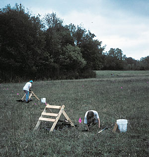
Chet Walker conducting metal detector survey. Photograph by Alfred L. Broden. |
Bill Pierson conducting magnetometer survey. Photograph by Alfred L. Broden. |
Tiffany Osburn conducting ground-penetrating radar survey. Photo by Alfred L. Broden.
|
|
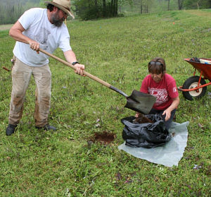
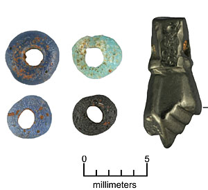
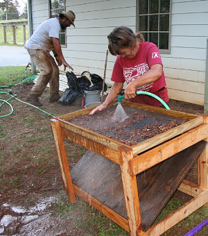
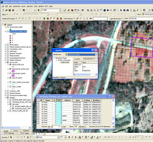
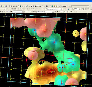
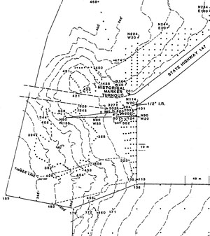
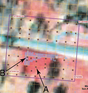
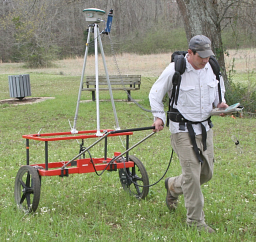
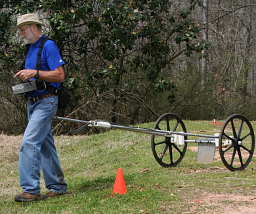
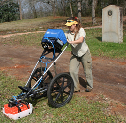
In the spring of 2008, after being awarded funding from the Bob and Kathleen Gilmore Endowment for French and Spanish Colonial Period Archeology in Texas, George Avery, assisted by Jeff Williams and Connie Hodges, conducted a shovel testing survey on a 10 meter grid covering both the Gilmore and Corbin excavation areas. Just prior to the shovel testing, Bruseth, Bill Pierson, Tiffany Osburn, and Chet Walker conducted geophysical surveys at Mission Dolores. Magnetometer and metal detector surveys covered much of the open area both north and south of highway 147. Ground penetrating radar survey focused on the area surrounding the remnant mission complex revealed by Corbin’s excavations. The geophysical surveys met with some success, but unfortunately, wet and highly ferruginous (iron-bearing) soils conditions made for difficult terrestrial remote sensing. The hope was to see a clear boundary of the mission complex, but this did not happen. Interestingly enough it was a color infrared aerial photograph that gave the most intriguing insights. The brightest red area—indicating an area of extremely healthy and vigorous vegetation corresponding to culturally altered soils—formed a triangular area around the mission compound as defined by Corbin. One shovel text outside the perimeter wall hit an almost 60cm deep mission period trash deposit (mostly animal bone, but also native pottery and hand wrought nails), much like the probable clay pits associated with structures as revealed by Corbin’s excavations that were subsequently filled with trash. It is possible, then, that either a structure existed outside the perimeter wall, or the mission compound is larger than previously thought. Based on this shovel test and the color infrared photograph, it is possible to recommend that when attempting to build a rendering (or simulation) of the mission complex, it should be no smaller than the extended area suggested by Feature 25 interpreted as a perimeter wall, and no larger than the extended area designated by the intense red area in the aerial photograph. All material from the 60 shovel tests was water screened through 16th-inch mesh window screen. This time-consuming recovery technique was used in order to recover tiny glass “seed” trade beads. Initial sorting has been completed and roughly one quarter of the samples have been check sorted a second time. Notable artifacts recovered include a very small higa made of jet (a black mineral) found within a trash deposit. Glass seed beads were also recovered. The absence of running water at the site ruled out water screening in 1977, but today water screening can be conducted on site. Seed bead color patterns might provide information related to different social or regional groupings during the colonial period. Blue and white predominate at many sites in the area, but Los Adaes is quite different as black predominates. Since the Adaes and Ais are generally considered somewhat different than the Hasinai and Cadohadacho, the question arises: will the seed bead color pattern also be different? The sample size for seed beads at Mission Dolores is currently too small to make a valid comparison with other sites in the area, but if there are numerous seed beads that went through the quarter inch dry screening of past excavations, they can be recovered by excavating the fill in these units and water screening it through 1/16th inch window screen. Mission Dolores GISIn conjunction with the 2008 investigations, Jeff Williams created a GIS (Geographic Information System) for Mission Dolores to incorporate all previous and new excavation information with the current physical landscape. Some background maybe helpful. GIS is an information system that uses spatial data linked (georeferenced) to a location on the earth that occurs in 3-dimensional space. Related geospatial technologies include Global Positioning Systems (GPS) and remote sensing. GIS is most commonly used as computer cartography for mapping; however, the real power of a GIS lies in the fact that it also stores information (attributes) about physical features as well as their locations. The GIS analyst can use these attributes to answer specific questions and spatially model �what if," "how far," or "how many� type questions and then display the results in the form of maps, graphs, charts, or text for decision making purposes. GIS has been used for many years in archaeology because of its strengths of managing and modeling large volumes of spatial data. The information system has contributed significantly to the modernization of research and study of human cultures and their interactions with the physical landscapes. A culturally altered landscape is composed of physical disturbances, some intended such as built up areas for foundations or dug out areas for trash pits, and some not intended such as increased erosion from animal or foot traffic or a change in the soil chemistry from plant or animal food processing. The archaeological record preserves a portion of these physical disturbances and at the landscape level is at best an incomplete catalog of the interactions of human activity and the natural world. A GIS for archaeology has the ability to manage, model, and visualize the character of the physical landscape while incorporating both historic and archaeological field data into a single interactive analysis tool. The Mission Dolores GIS was used to integrate the geophysical survey data with previous excavation information and to develop a strategy for placement of the 2008 shovel test units. The creation and integration of a comprehensive archaeological GIS required tying the GIS location origin to Corbin’s previous 1-meter excavation grid. Permanent concrete markers had been placed in 1976 and 1977 at the locations of his grid’s datum points. The concrete markers had, however, sunk below the grass line or had been accidently removed by mowing during the intervening years. Through a combination of GIS map overlay, metal detecting, hard work, and a bit of luck, Corbin’s grid datum points were found, relabeled, and located with a survey grade sub-meter GPS unit with a horizontal accuracy of less than 0.20-meter. Precisely tying the GIS to the previous excavation grid facilitated the inclusion of 30 years of excavation data and allowed for interactive and iterative questioning of the data for determining strategic excavation choices. After adding Corbin�s excavation grid, the Mission Dolores GIS was used for display of georeferenced aerial photography and satellite imagery. This remote sensing data was analyzed in the GIS for differences in vegetative patterns, vegetation health, visible surface patterns, and discernable surface trends that might indicate cultural modifications to the landscape. Beginning with a 1996 color infrared aerial photograph, a pattern of brighter red was seen at the excavation site. The pattern persisted though several years of aerial photographs with the most recent being 2008. Initially it was believed that the bright red area visible on the aerial photography was caused by the vegetation of the reseeded area outlining Corbin’s backfilled excavations. It became apparent, however, that the bright red area extended approximately 20-meters further south than Corbin’s excavations. The bright red pattern warranted further investigation. Soil sampling was conducted at each shovel test with the soil samples near the southern limits of the bright red area being predominately a dark red gravely sandy loam with a greasy or oily feel. Preliminary soils’ testing indicates increased phosphorus (P) content within the bright red area possibly from the residue of large-scale animal butchering, marrow rendering, and/or hide processing. The GIS was able to accurately place the previous excavation grid in its correct location with the bright red feature of the aerial photograph and helped to determine that the Spanish occupation of the Mission Dolores site is much larger than originally thought. Additional work by the Carlson and Avery investigations has concluded that Spanish artifacts extend beyond Corbin’s investigations and that the dark organically enriched somewhat oily or greasy soils extend beyond previous estimates of the limits of the mission site. Three and a half decades after she last worked at Mission Dolores, Dr. Kathleen Gilmore visited the Avery investigations in the spring of 2008 while the geophysical survey was in progress and brought her rare insight and unique perspective to discussions of the survey results. Dr. Gilmore�s many years of research and study of Spanish Colonial interactions provided a one-of-a-kind historical overview of early Spanish Texas. She outlined details of construction techniques, the placement of structures within mission compounds including the chapel and priest�s quarters, the placement of structures outside the compounds, and the relationship of old roads to mission locations. At Mission Dolores, Dr. Gilmore believed that the placement of the well (Feature 13) within the confines of the palisade wall (Feature 25), the possible adobe structure adjacent to the well (Feature 32), Corbin�s old road feature (Feature 65) and a newly identified swale all indicated that originally, El Camino Real passed right through the middle of the mission compound. Much like highway 147 does today. |
|