The Spanish response to St. Denis’ trading post among the Natchitoches on the Red River in today's northwestern Louisiana and his visit to San Juan Bautista was an expedition begun in 1716 and led by Diego Ramon’s son, Domingo. This expedition established six missions and a presidio in East Texas, including Mission Dolores. It appears that the intent was only to establish four missions, but when Father Antonio Margil and others went to visit Natchitoches they encountered the Ais and Adaes Indians, and missions were established for these groups as well.
In 1719, France and Spain were at war and St. Denis was called to participate in the French attack on Spanish Pensacola. At the Natchitoches post, a French lieutenant took it upon himself to organize an attack on the Spanish mission for the Adaes—Mission San Miguel de los Adaes (see Los Adaes). The French attack by seven soldiers encountered a sleeping Spanish soldier and lay brother at Mission San Miguel. The priest and other soldier assigned to the lonely post were then at Mission Dolores. The victorious French began to gather up Spanish chickens and tying them in pairs at the legs and slinging the pairs across their horses. The chickens carried by the French lieutenant put up such a fuss that his horse reared up and threw him to the ground. The Spanish lay brother took advantage of the noisy confusion and escaped, fleeing to Mission Dolores and spreading the word that the French were coming.
News of the French “attack” at Mission San Miguel prompted the alarmed Spanish to abandon all the Spanish positions in East Texas. A year later, likely motivated by a desire to protect his large land holdings in northern Mexico from French threat, the Marqués de San Miguel de Aguayo led and paid for much of the expedition that re-established the Spanish foothold in East Texas. In 1721 the Aguayo expedition re-established Missions Dolores and San Miguel in more defensible positions and built a presidio with 100 soldiers close to Mission San Miguel.
Thirty-one of the 100 soldiers associated with Presidio Nuestra Señora del Pilar de los Adaes brought their families. Aguayo was well aware of the problems of the earlier missions and he wanted to make sure that the soldiers assigned to the missions were family men. Aguayo was made governor of the provinces of Coahuila and Texas in 1719 when he promised to finance the expedition, and he resigned as governor in 1722, leaving the province with four presidios and ten missions, where before his expedition there was only one presidio and two missions. The subsequent governors of the province of Texas would live at Presidio Los Adaes.
After the Aguayo expedition, the Spanish in Texas were braced for an attack by the French, but it never came. Instead, the French lieutenant responsible for the Chicken War (as historians now refer to the 1719 event) was reprimanded and the items stolen from Mission San Miguel were returned. An inspection of the presidios of Texas in 1727 by Pedro de Rivera revealed a peaceful situation in the Spanish-French borderlands. Rivera entered Presidio de los Tejas (Presidio Dolores) on the Angelina River and found no one on guard duty. The soldiers explained that they got along so well with the local Indians that they did not post guards. Rivera also observed no Indians living at any of the six missions of eastern provincial Texas, including Mission Dolores.
Rivera recommended closing Presidio de los Tejas and reducing the number of soldiers in the area from 100 to 60. The lack of Indians living at the missions resulted in the moving of Missions San Francisco, San José, and Concepción to the San Antonio area. After 1730, there were only three missions in East Texas—Guadalupe (among the Nacogdoches Indians), Dolores, and Los Adaes, and one presidio (also at Los Adaes) remaining in the northeastern region of the province of Texas.
|
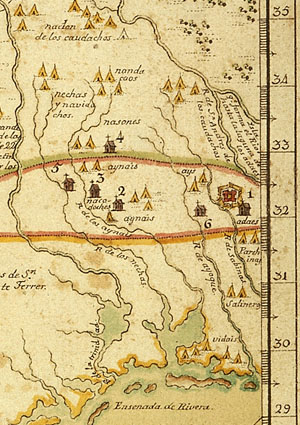
Later version of a 1728 Spanish map, one of the first maps to show the location of Mission Dolores (#6). Enlarge to see details.  |
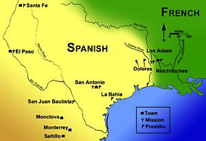
The Spanish-French frontier in early 18th century and select localities in northeastern New Spain. |
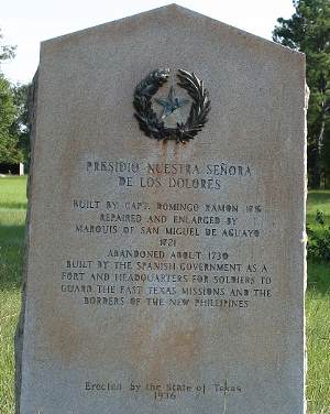
Historical marker commemorating Presidio Nuestra Señora de Los Dolores. Built to protect Spanish missions in East Texas, it was moved several times during its existence. Although they share the “Dolores” name, the presidio and the mission were never close by. Photograph by George Avery. |
|