Texas Beyond History
TBH Home
Frontier Forts Main

Cultural Collisions in the Hill Country

"The Redoubtable Sergeant"
"The Redoubtable Sergeant" by artist Don Stivers depicts Sergeant Emanuel Stance (second from left) and troopers of the 9th U.S. Cavalry—part of the famed Buffalo Soldiers—at the Battle of Kickapoo Springs against Apache Indians north of Fort McKavett in 1870. It was one of many bloody clashes between the vastly different cultures that vied for control of the Texas Hill Country. For his valor, Sergeant Stance was awarded the Medal of Honor, the first given to an African-American soldier. Read orders for scout along Kickapoo Creek. Image courtesy of Don Stivers.
Presidio San Sabá
Ruins of Presidio San Sabá near Menard. Established by the Spanish in the mid-1700s to guard the nearby Lipan Apache mission, the location—in territory fiercely contested by Comanches—proved disastrous. Photo by Susan Dial.

Click images to enlarge  

1857 map of Texas
"Historical bookends": The two forts on the San Saba river, Fort McKavette (sic) and the mid-18th-century Presidio San Sabá. Detail of 1857 map of State of Texas by Henry Darwin Rogers and Alexander Johnston, courtesy David Rumsey Map Collection.
Lipan Apache
Lipan Apache. Pushed from the Edwards Plateau by Comanches, the Lipan sought protection temporarily in Spanish missions. Friendly at first to Anglos, they became feared raiders as more settlers moved onto the Plateau and resources had to be shared. Painting by Lino Sanchez y Tapia, circa 1828, drawn during the Berlandier Expedition. Image courtesy of the Gilcrease Museum,Tulsa.
Site of Mission Nuestra Senora de la Candelaria del Canon
Site of Mission Nuestra Senora de la Candelaria del Cañon, one of two missions established on the upper Nueces by the Spanish for the conversion of the Lipan. Photo by Susan Dial.

One could almost call them historical bookends, the Spanish presidio and the United States Army fort separated by 20 miles and 100 years. Located off U.S. Highway 190 on opposite banks of the San Saba River west of modern Menard, these two outposts of European-based culture are mute reminders of the conflict on the Edwards Plateau in the 18th and 19th centuries.

Through most of the 1600s, the High Plains of what today are eastern New Mexico and the Texas panhandle had been the range of native groups known to the Spanish as "Apache." In the early 1700s, Comanche horsemen began to push onto the Plains and the Edwards Plateau. As they reached the broken Hill Country, they encountered resistance from the Apache people called "Lipan."

Spain had established a productive mission complex among the Pueblo Indians near Santa Fe and along the valley of the upper Rio Grande. But by the mid-1700s the Spanish had only a tenuous hold on the land mass that is modern Texas. The eastern settlement most comparable to Santa Fe was at San Antonio, but it was a shadow of its New Mexico counterpart.

The Lipan occasionally raided the San Antonio missions, but in 1749 four of their chiefs made a peace agreement with the Spanish and appeared willing to accept missionaries in return for protection from the Comanche. After a mission on the Rio Grande proved unsuccessful, the Spanish tried again in what they believed to be Apache homeland near the heart of the Edwards Plateau. The chosen location was in a region contested by the Comanche.

The mission Santa Cruz de San Sabá was established on the south bank of the San Saba River in 1757. The protective fort, Presidio San Luís de las Amarillas, was located approximately four miles upstream, on the north bank. Lipan drifted into the mission slowly, but even then refused to stay. The puzzled Spanish had located the mission in a war zone, and in doing so had inadvertently made themselves targets of the Comanche.

Less than a year after construction, the mission and presidio were attacked by a large force of Comanche, Wichita, Tonkawa, and other Indians. Eight inhabitants of the mission were killed, and it was looted and burned. The survivors joined the soldiers inside the presidio, where they took refuge until the attackers withdrew.

Mission San Sabá was soon abandoned, and other missions were established for the Lipan on the Nueces River. These had some modest success, but a smallpox epidemic and Comanche raids finally drove the Lipan away. They would return to raid the Spanish settlements around San Antonio.

The Comanche meanwhile strengthened their hold on the Edwards Plateau. The presidio of San Sabá survived until 1772 when it, too, was abandoned. San Antonio and the surrounding area began to experience Comanche raids in the early 1770s. Travel to the north or west became dangerous, and most commerce and communication from San Antonio to Santa Fe flowed southwest, across the Rio Grande to Monclova, then west across northern Mexico to Chihuahua, and finally north through modern El Paso to Santa Fe. The Comanche range—Comanchería—extended from the Rocky Mountains east of Santa Fe to the Hill Country above San Antonio.

At the beginning of the 1800s, the Spanish were desperate for a way to protect their Texas frontier from Indian attack. The empresario arrangement with Moses Austin for the settlement of Anglo colonists from the United States was considered to be Spain's last hope to establish a buffer for its beleaguered Mexican settlements below the Rio Grande. After the Mexican revolt against Spain finally succeeded in 1821, the Texas settlements were virtually bereft of military protection. Only 59 soldiers were left in the province to guard about 4,000 people. The new Mexican government was unable to defend its own northern settlements or those of the new colonists in eastern Texas.

The Edwards Plateau became part of the home range of the Penateka band of Comanche, The Penateka name translated roughly as "Honey Eaters," possibly an allusion to the richness of the plant and wildlife resources found near their camps along the streams of the Hill Country. They had other names as well, one of which translated as "Wasps," or "Quick Stingers." Settlers victimized by their raids could attest to the appropriateness of those references.

headquarters building
Fort McKavett was established near the headwaters of the San Saba River in 1852. Major renovations and additions between 1867 and 1883 included the post headquarters, or administration building, pictured here. Photo by John Cobb.


These two outposts of European-based culture are mute reminders of the conflict on the Edwards Plateau in the 18th and 19th centuries.

"The Destruction of Mission San Sabá in the Province of Texas and the Martyrdom of the Fathers Alonso de Terreros, Joseph Santiesteban."
"The Destruction of Mission San Sabá in the Province of Texas and the Martyrdom of the Fathers Alonso de Terreros, Joseph Santiesteban." Painted less than a decade after the brutal Indian attack on the mission, the work was commissioned by a cousin of one of the martyred priest.
map of Comanche migration
Migration of Comanches into Texas during the 1700s came at the expense of Plains Apaches, who had long occupied large portions of the southern High Plains and Edwards Plateau. After driving Lipan Apaches away from the Spanish mission Santa Cruz de San Sabá, the Comanches attacked the Lipan who moved to the missions in the El Cañon region of the upper Nueces River. Adapted from Betty, 2002.

The Penateka Comanche's name translated roughly as "Honey Eaters," possibly an allusion to the plant and wildlife resources found along the streams of the Hill Country. The Comanche had other names as well, one of which translated as "Wasps," or "Quick Stingers." Settlers victimized by their raids could attest to the appropriateness of those references.

wild turkeys
San Saba river
white-tail deer
Rich resources of the Hill Country-Edwards Plateau, then as now, include a variety of wildlife, plants, and abundant water from clear streams and springs. The land and its natural wealth served as a powerful attractant to Indians and Anglos alike. From left, wild turkeys, photo courtesy Texas Parks and Wildlife; the San Saba river near Fort McKavett, photo by Susan Dial; white-tail deer, photo courtesy Texas Parks and Wildlife.
Austin map
The capital of Texas was relocated to Austin (then the tiny burg of Waterloo) in 1839. Situated upstream from Bastrop on the Colorado River and on the fringe of the Penateka range, its location forced a new plan for Texas' defense, including a regular army and construction of forts. Map of Texas 1840, courtesy of David Rumsey Map Collection.
Plains Indian warrior
Plains Indian warrior by Texas artist Fredrich Richard Petri. One of the few nineteenth-century artists who painted Texas Indians, Petri recorded people and scenes near his Fredericksburg farm in the 1850s, including Peneteka Comanches who were captivated by his skill with a paintbrush. Image courtesy Texas Memorial Museum, U.T.-Austin.

Prior to their own revolt against Mexico, the Anglo-Texans had little contact with the Penateka. San Antonio was still primarily a Spanish-Mexican town. But the flood of immigration that accompanied nationhood pushed white settlement to the Balcones Escarpment, which formed the eastern and southern rim of the Edwards Plateau. In 1839, President Mirabeau B. Lamar succeeded in having the capital of the Republic of Texas relocated to the north bank of the Colorado River some 30 miles upstream from the town of Bastrop. The site selected, a tiny hamlet originally called Waterloo, lay on the fringe of the Penateka range.

The act at first was largely symbolic, a westward shift of the seat of government—soon to be named "Austin"—that matched Lamar's vision of a great Texas empire. But it also forced the Texas Congress to accept Lamar's plans for frontier defense, including the financing of a regular army and the construction of military posts along the edges of white settlement. Three initially were built: Fort Houston on what was then the northern frontier, Fort Colorado (also known as the Walnut Creek Fort) near Austin, and Fort Little River (also known as the Three Forks Fort) more or less midway between the other two.

But settlers were not content to merely defend the territory they already occupied. Early in 1839, veteran Indian fighter John Henry Moore led a force against a Comanche camp above the San Saba River. Although the expedition's success was debatable, it did signal to the Penateka that the Anglo-Texans would not be passive victims of Indian raiding. A cholera epidemic swept through the Comanche camps in the winter of 1839-1840, and spring brought the disaster of the Council House fight in San Antonio. Successive hammer blows struck the Penateka in battles at Plum Creek and their own camp on the Concho River later in the year.

The Penateka could not stand such a succession of losses, and they withdrew from much of their home range. For the next 15 years, they alternately raided the fringes of white settlement, bartered with official traders appointed by the Republic of Texas, and negotiated with Indian agents of the United States. Although they never again were able to hold the Edwards Plateau against invaders, they continued to use it as their range and as a route for raids into Mexico.

Aftermath of an Indian attack
Aftermath of Indian attack on an early Texas farm as depicted in an 1890 edition of Harper's Magazine (Vol. 80:731).

Settlers were not content to merely defend the territory they already occupied. When veteran Indian fighter John Henry Moore led a force against a Comanche camp above the San Saba River in 1839, it signaled to the Penateka that Anglo-Texans would not be passive victims of Indian raiding.

Battle of Plum Creek
On a path of destruction stretching from Linville in south Texas to east of Austin, Comanche raiders are intercepted by citizen militia and rangers at the Battle of Plum Creek. Engraving from sketch by T.J. Owen (a pseudonym for the author, O'Henry), from Wilbrager, 1889.
ruins at Moss ranch
Ruins of rock wall at Moss ranch. White settlers, many of them European immigrants, began moving into the river valleys of the Texas hill country early in the 1840s. Before the invention of barbed wire in the late nineteenth century, stone fences, such as this one, were used to enclose small gardens as well as fields. Photo by Susan Dial.
Hill Country prior to 1855
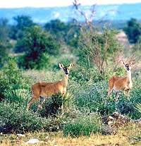
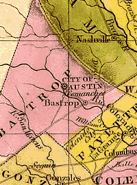
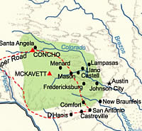
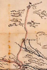
Anglo marks on the Hill Country frontier: Army posts and some of the settlements in the 1840s and 1850s.
Fort Martin Scott
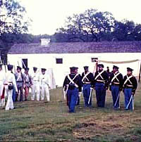
Fort Martin Scott, established in 1848 in Fredericksburg, was tasked with guarding the German settlements on the western frontier. Here, history interpreters depicting soldiers of the 1840s practice drills in front of the guardhouse at the fort. Photo by Roy Betzer, courtesy the Gillespie County Historical Society.

It was quickly evident that most of the forts were located too far east—on or behind the frontier of settlement—to give even mounted troops a chance to do anything about the raiders except chase them after they had struck.

Gustave Schleicher
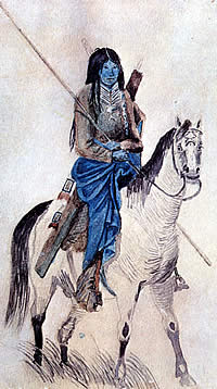
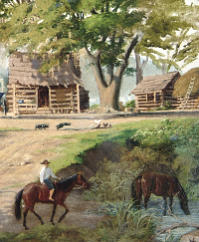
Llano County pioneer Gustave Schleicher was a member of the Bettina Colony, established by the Adelsverein in 1847 along with Castell and several other small burgs on the Llano River. With the exception of Castell, none of these early settlements —made up chiefly of highly educated German freethinkers—survived. Painting in Llano County Museum, Llano, Texas, gift of Sam Schleicher.
Ft. Mason
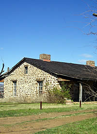
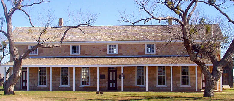
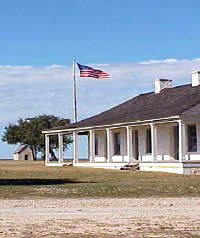
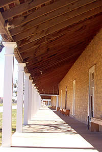
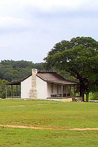
Situated high on a hilltop, this reconstructed building at the site of Fort Mason commands a view of the town below. Photo by Susan Dial.
Dutch House drawing
Dutch House in Frederickburg, Texas, Residence of the Parson, January 28, 1849. Detail of sketch by Seth Eastman. Courtesy of the McNay Art Museum, gift of the Pearl Brewing Company.
remada shelter
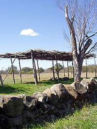
Reconstructed ramada shelter at site of Fort Inge. The post was situated on the Leona river west of Castroville, near the present-day town of Uvalde. In the foreground is a wall made of igneous rock from nearby Pilot's Knob. The low stone foundation of a fort structure is visible in the background. Photo by Susan Dial.

By the mid-1840s, white settlement pierced the Balcones Escarpment and began to creep up the Plateau's river valleys. The first of these extensions was the colony of French banker-diplomat Henri Castro, who settled his Alsatian immigrants in the Medina River valley west of San Antonio. German immigrants were drawn to the huge Fisher-Miller tract between the Llano and Colorado Rivers, but settled first on the Guadalupe River north of San Antonio and the Pedernales River to the northwest. These communities—New Braunfels and Fredericksburg, respectively—combined with Castroville to constitute what was considered at the time to be the "Western Frontier" of white settlement in Texas.
.
At the end of the United States' war with Mexico in 1848, protection of Austin and the German and Alsatian settlements became the responsibility of the U.S. Army. The southern anchors of a "frontier line" of forts were placed near the edge of the Edwards Plateau. Fort Martin Scott was established in 1848 at Fredericksburg, the settlement most exposed to Plains Indian raids. Then followed Fort Croghan, located near the Colorado River above Austin; Fort Lincoln, on Seco Creek north of the Alsatian hamlet of D'Hanis; and Fort Inge, on the Leona River west of Castroville.

Although Fredericksburg may have appeared to be the most vulnerable settlement, defense of the Castro Colony occupied more of the Army's attention in the early 1850s. The settlements at the base of the Balcones Escarpment frequently were victimized by Indian raiders, and companies of the 2nd Dragoons from Fort Inge and Fort Lincoln occasionally were able to conduct a fruitful pursuit.

It was quickly evident, however, that most of the forts were located too far east—on or behind the frontier of settlement—to give even mounted troops a chance to do anything about the raiders except chase them after they had struck. The army's answer to this problem was to abandon most of the original "frontier line" of forts and to construct a second series of posts farther west.

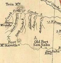
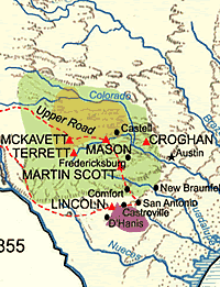
A garrison was retained at Fort Inge, the westernmost of the original posts. Forts Croghan, Martin Scott, and Lincoln were vacated. Fort Mason was established about 40 miles northwest of Fredericksburg as a replacement for both Croghan and Martin Scott. Fort McKavett was located near the headwaters of the San Saba River, about 40 miles west of Fort Mason, and Fort Terrett was placed about 40 miles south of McKavett on the north fork of the Llano River.

Forts McKavett and Terrett were situated near one of the Comanche travel routes from the Plains into Mexico. This was a matter of some consequence. The United States, as part of the Treaty of Guadalupe Hidalgo that concluded the Mexican War, had agreed to try to stop Indian raids into Mexico. Fort Inge, about 125 miles almost due south of McKavett and just off the Edwards Plateau, gave the army a third post near the Comanche trail.

This scheme, though logical, was at first ineffective. Fort Terrett was abandoned in 1854, only two years after it was established. Fort McKavett lasted seven years, but there are no reports of Indian fights involving troops from the post during that time. Companies of the 2nd Dragoons and the Regiment of Mounted Riflemen garrisoned at Fort Inge directed most of their attention to the Nueces Strip—the plain between the Nueces River and the Rio Grande—because of the frequency of raids on ranchos near Laredo.

The situation changed in 1856, with the arrival and deployment of the 2nd Cavalry. This regiment was to become one of the most celebrated units in the history of the United States Army, and included 16 future Civil War generals among its officer corps. Its commander, Colonel Albert Sidney Johnston, established headquarters at Fort Mason.

Johnston and the regiment's lieutenant colonel, Robert E. Lee, put the unit to the task of scouring the country from the Brazos River to the Nueces—the entire Edwards Plateau and then some—in search of Indians. The regiment recorded more hostile actions against Indians than any other U.S. Army unit in Texas prior to the Civil War. Nearly two-thirds of the engagements occurred on the Edwards Plateau.

With the coming of secession and Civil War, Texas frontier folk fell back on the same types of defenses they had used during the Republic period: Texas-funded regular troops (the "Frontier Regiment"), militia, and a Frontier Organization that patrolled similarly to the rangers of the Republic but functioned no more efficiently than militia. 
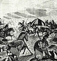
By 1864, the frontier was under assault by northern Comanche and their Kiowa allies.

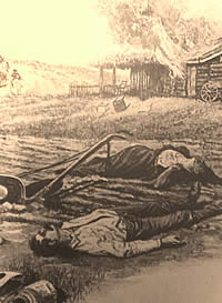
Reports received from some officials of frontier counties indicate 163 settlers killed, 24 wounded, and 43 carried away by Indian raiders during the period from the summer of 1865 to the summer of 1867. Many of these were no doubt from the counties north of the Edwards Plateau, above the Brazos River, where settlements were particularly vulnerable. But anecdotal reports from the Hill Country reflect a serious enough condition there. From Llano to Lampasas, the stories were the same: it had been 20 years since the Indians had been so numerous, so well-armed, and so bold; farmers were regularly being shot down in their fields, or their livestock driven away as they watched helplessly; the frontier was "breaking up," would have to be abandoned.

After the war, the state was prohibited from fielding its own defense forces. The U.S. Army was quick to get troops to the Rio Grande, but moved much more slowly to the western frontier. This reflected the army's concern, and that of the national government, for the international boundary and the post-war Reconstruction mission. One company of the 4th Cavalry was posted to Fort Martin Scott early in 1866 and another to Fort Inge. In November and December of that year, two companies were sent to Fort Mason and three to Camp Verde, south of Fredericksburg in modern Kerr County.

Henri Castro's house
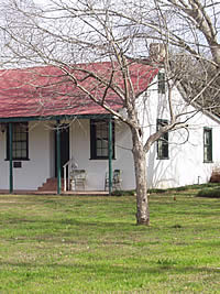
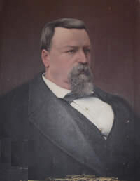
Home of Henri Castro, founder of Castroville. Beginning in the early 1840s, Castro brought settlers from Germany, Alsace-Lorraine, and France to the far western edge of the frontier, some 30 miles west of San Antonio. In spite of repeated Indian attacks, disease, and severe drought in 1848, the community survived and still thrives today. Photo by Susan Dial.
Fort Martin Scott
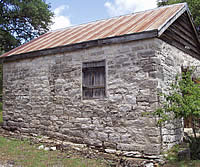
Buildings at Fort Martin Scott were made of logs or of plastered limestone, the latter by skilled German masons hired from among the Fredericksburg populace. Photo by Susan Dial.
kitchen
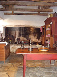
Early Fredericksburg kitchen. The inviting warmth of the fireplace beckoned weary settlers at day's end on the Texas frontier. Shown is the 1840s Kammlah house in Fredericksburg, now maintained as part of a museum complex by the Gillespie County Historical Association. Photo by Susan Dial.
New Braunfels
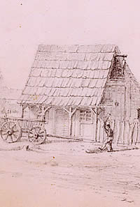
Block House, or Log Cabin, New Braunfels. Detail from painting by early Texas artist Carl G. von Iwonski, courtesy of the Daughters of the Republic of Texas Library, Yanaguana Society Collection. Click to see full painting.
Hill Country post 1855
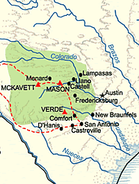
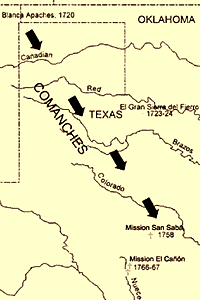
Hill Country frontier after 1855.
Robert E. Lee
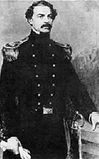
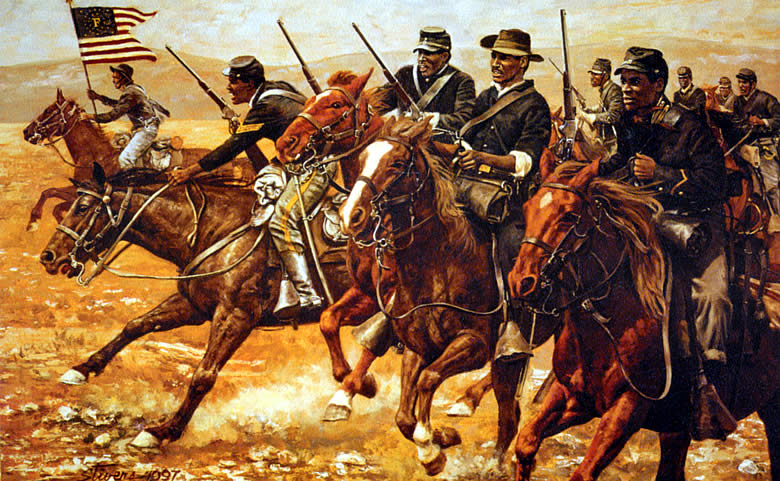
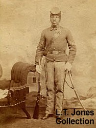
Robert E. Lee was one of numerous officers posted to the Texas frontier who became Civil War generals including Albert Sidney Johnston, Earl Van Dorn, E. Kirby Smith, George H. Thomas, John Bell Hood, and William J. Hardee. Johnston established the 2nd Cavalry's headquarters at Fort Mason, with Lee second in command.
Ft. Croghan
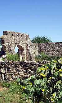
Powder magazine at site of Fort Croghan in Burnet. The building, used by local settlers before and after the Civil War, is the only remaining military structure at the site of the early fort. Photo by Susan Dial.
Ft. Concho
Headquarters at Fort Concho. Established in 1867, the fort, garrisoned by companies of the 4th and 9th Cavalry, was positioned to deflect Comanche and Kiowa raiders from the Hill Country. Photo by Susan Dial.
Hill country post 1866
Forts and towns on the Hill Country frontier after the Civil War.
Settler's grave
Settler's grave. William McDougall was killed and his stepdaughter severely wounded during a raid on his farm near Fort McKavett. Several thousand head of livestock also were driven off during the 1866 attack. During the Civil War, when frontier defense was left to civilian militia and rangers, Indians often raided more than 100 miles east of the pre-war line of defense.
Elizabeth Schellenbarger
Pierced by an Indian lance during a 1866 raid on her stepfather William McDougall's farm, Elizabeth Schellenbarger recovered from her wounds and is shown at far right in this photo. Photo courtesy Texas Parks and Wildlife, Fort McKavett SHS.

A new post on the Concho River—Fort Concho—was established two years later and Fort McKavett was reoccupied. But the cavalry companies were removed from Fort Inge, Fort Mason, and Camp Verde, and Fort Martin Scott was again abandoned. In 1869, Fort Inge, Fort Mason, and Camp Verde went the way of Martin Scott.

Forts McKavett and Concho were garrisoned initially by companies of the 4th Cavalry and 9th Cavalry, with infantry companies in support. The 4th would win renown as one of the hardest fighting outfits in the army during the Indian Wars. Its total of 36 engagements while stationed on the Texas frontier equaled that of the pre-war 2nd Cavalry. But it was the 9th that carried the heavy load of patrol and pursuit during the early post-Civil War years.

The 9th was manned by black enlisted personnel and white officers. From 1867 to 1875, the 9th had patrol and escort responsibilities for most of southwest Texas. In addition to its postings at Fort Concho and Fort McKavett, its companies were strung out among Forts Davis, Quitman and Stockton in the Trans-Pecos region; Fort Clark on the southern rim of the Edwards Plateau, and Fort Duncan, Fort McIntosh, and Ringgold Barracks on the lower Rio Grande.

Between them, the 4th and 9th Cavalry fought only a dozen engagements with Indians on the Edwards Plateau proper. But the location of Forts Concho and McKavett, and the heavy regimen of mounted patrols emanating from those posts, helped deflect Comanche and Kiowa raiders away from the Hill Country settlements as the Indians traveled to and from Mexico.

The frontier forts both provided protection for civilians already in the area and served as a magnet for further immigration. The army's need for goods and services created a cash market for local farmers, stockmen, and tradesmen. Products that could not be provided by local suppliers were freighted in from San Antonio, by either army wagons or civilian contractors. The "military road" that connected San Antonio to Fort Martin Scott, then to Fort Mason and Fort McKavett and, ultimately, to Fort Concho, served both the army and the civilian communities through which it passed.

This route was the first leg of what was known as the "upper road" from San Antonio to El Paso after the Civil War. The army's pre-war route—known as the "lower road"—ran directly west from San Antonio, through Fort Inge and Fort Clark, before turning northwest and crossing the Devil's River and the Pecos River. Shortly after Ben Ficklin took control of passenger and mail transportation on the El Paso Road in 1867, operations were shifted from the "lower" to the "upper" route. After passing near Fort Concho, the road turned southwest to the Pecos, running roughly along the same line as the old Butterfield mail route and the Goodnight-Loving cattle trail.

Ficklin established relay stations along the route at and between forts and settlements. The station on the Concho River became the junction of the San Antonio and El Paso road and the one from Fort Smith, Arkansas, that came by way of Fort Belknap, Fort Richardson, and Fort Griffin. The latter was essentially the north Texas stretch of the former Butterfield trail, and the intersection of these two routes turned the Concho station into a frontier crossroads. Two settlements—one called "Benficklin" and the other, closer to Fort Concho, known as "Santa Angela"—were soon competing for commercial supremacy in the area. Benficklin succumbed to a flood on the Concho River. Santa Angela, sometimes referred to by soldiers merely as "over the river," survived to become the county seat of Tom Green County.

Sgt. 10th U.S. Cavalry, a "Buffalo Soldiers" regiment. Photo courtesy of Lawrence Jones, III. View large image.
bugle
Calls from the past: period bugle and drum from the Fort Concho Museum. The post bugler was responsible for sounding some 15 calls throughout the day, from Reveille to Mess to Taps, signaling the men to duty, to meals, and to bed. Fort Concho Museum.

From Llano to Lampasas, the stories were the same: it had been 20 years since the Indians had been so numerous, so well-armed, and so bold; farmers were regularly being shot down in their fields, or their livestock driven away as they watched helplessly; the frontier was "breaking up," would have to be abandoned.

Bandera
Hay gathering in Bandera County, circa 1900. Photo courtesy of the Texas Historic Commission.
pack saddle sunset pack saddle marker
Scene of the last Indian battle in Llano County. On the heights of the Packsaddle Mountains at what is now Kingsland, settlers attacked a band of Indians believed to have been stealing livestock in the area. Photo by Susan Dial.
Map of a scout
Map of a scout by a detachment from Fort McKavett to the North Llano River during the twilight years of the post's Army service. The dashed red line indicates the route of Lieutenant Mosher and his command, and the designation, "camp," indicates an overnight stop. A patrol much like this one resulted in the battles that earned Sergeant Emanuel Stance the Medal of Honor 10 years earlier. Crimmins Collection, courtesy Center for American History, U.T.-Austin.

By the end of the 1870s, the Comanche and Kiowa raiding had ceased. With the northern frontier secure, the army vacated Fort Richardson in 1878 and Fort Griffin in 1881. Fort McKavett followed in 1883, its buildings quickly occupied by the stockmen and merchants who had been drawn to the area within the protection of the army's cavalry patrols. Fort Concho hung on until 1889. After the fort was abandoned, its buildings slowly were incorporated into the renamed community of San Angelo.

Much of Fort Concho and Fort McKavett has been preserved or restored. The Fort Concho National Historic Landmark is today operated by the city of San Angelo. Fort McKavett State Historic Site is maintained by the Texas Parks and Wildlife Department. The Gillespie County Historical Society is continuing an ambitious reconstruction program for Fort Martin Scott at Fredericksburg. There is little remaining or reconstructed at Forts Inge, Croghan, and Mason; the sites are maintained by the cities of Uvalde, Fredericksburg, Burnet, and Mason, respectively. Camp Verde and the site of Fort Lincoln are both on private land.

Ruins of the presidio of mission San Sabá were used in a reconstruction of the Spanish fort in 1936 as a project of the Texas Centennial observance, but the presidio is again in a state of collapse. Current excavation and restoration efforts are an enduring legacy of Spain's fragile, yet stubborn, presence on the Edwards Plateau.

Further reading is available on Texas Beyond History about Presidio San Sabá and the Mission.

wagon train
A wagon train of settlers pauses at Fort Concho. Two of the primary immigrant roads through western Texas intersected near Fort Concho and turned the small town of Santa Angela into a major regional commercial center. In this photograph, a civilian wagon train is stopped at the fort, possibly to rest, resupply, or request assistance. Troops not engaged in other duties sometimes would be assigned to escort groups of civilian travelers. Photo courtesy of Fort Concho NHL.
walkway
Long view down rows of enlisted men's barracks at Fort Concho. Encircled by the city of San Angelo which has grown up around it, the post has been restored and is a National Historic Landmark. Photo by Susan Dial.