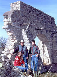
The team that rediscovered the location
of Mission San Saba: historian and historical archeologist
Kay Hindes, archeologist Grant Hall, and architect Mark
Wolf, whose interest in his genealogy sparked the discovery.
Photo by Mark Mamawal, Texas Tech University.
|
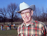
Noted historian Robert S. Weddle.
Like John Warren Hunter before him, Weddle was once
the editor of the newspaper in Menard. He became deeply
interested in the Spanish history of the Menard area
and would later write a popular book—The San Saba
Mission, Spanish Pivot in Texas—the complete story
of the presidio and mission. Photo by Mark Mamawal,
Texas Tech University.
|
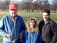
Judge Otis Lyckman, Kay Hindes, and
Mark Wolf. County judge for 25 years, Lyckman has a
strong interest in historic preservation in Menard County.
He led efforts to preserve and restore the presidio.
Judge Lyckman and his wife, Dionitia, gave their permission
for excavations to proceed once the mission was found
on their property east of Menard. Their close cooperation
was critical to the successful investigation of the
mission site. Judge Lyckman was particularly fascinated
by the fired daub marking the mission. He said that
he had noticed these baked clay lumps in the past as
he plowed his alfalfa field. They seemed out of place,
and not a natural thing to be occurring in his field.
He wondered what they were, but never dreamed that they
were evidence of the mission buildings that burned on
his land in 1758.
|
|
Historians and archeologists began trying to
relocate Mission San Sabá in the mid-1960s with the
work of Kathleen Gilmore and Dessamae Lorrain. Continued efforts
into the early 1990s had no better luck. A few years later
things took a different turn when a San Antonio architect,
Mark Wolf, began tracing his genealogy. Much to his surprise,
he learned he was a direct descendant of Juan Leal, a Spanish
soldier who had been stationed at the ill-fated mission to
assist the priests. When the Indians attacked the mission
in 1758, Leal organized the defense of the survivors holding
out in the church at the mission. He set up a small cannon
on some boxes and periodically fired it out the door to keep
the Indians at bay. When night fell, Leal and the other survivors
were able to sneak out of the burning mission and make their
way to the safety of the presidio four miles to the west.
Leal later moved to San Antonio, where he lived out the rest
of his life as a prominent citizen in that community.
Intrigued by his connection to the story, Wolf
asked Kay Hindes, historian and archeologist from Jourdanton,
if she would take him out to Menard and show him the mission.
She told him that the location of the mission was unknown
despite repeated attempts to find it. Undaunted, Wolf enlisted
Hindes' help to find the mission. They started with a survey
report authored by Shawn Carlson, a Texas A&M archeologist
who had led the last effort to find Mission San Saba. Carlson,
following the research of Kathleen Gilmore, had narrowed the
search to an area along the south side of the San Saba River
east of Menard. Carlson recommended that future searches for
the mission incorporate remote sensing techniques such as
aerial photography.
Wolf persuaded a friend who owned a small
plane to help out. They flew over the San Saba River valley
east of Menard and took photographs with different types of
film (color, black-and-white, and infrared). Mark Wolf got
his photos developed and began looking them over for any sign
of the mission. He noticed a couple of promising outlines
on the ground, linear soil discolorations that he thought
could be the remnants of the outer wall or stockade of the
mission.
In the spring of 1993, Wolf and Hindes contacted
me (Grant Hall). They asked if I would bring my Texas Tech
archeology field school students over to Menard that summer
to test one of the locations that looked promising in the
aerial photographs. My students and I were joined by Kathleen
Gilmore and Shawn Carlson, both of whom still had a keen interest
in helping locate the site. Unfortunately, the anomalies in
the photographs we investigated during the summer of 1993
all turned out to be false leads.
While Wolf was looking at aerial photos and
we were testing sites, Kay Hindes had been doing research
at the Center for American History at UT Austin. There she
found a pamphlet entitled "The Rise and Fall of Mission
San Saba. " It was written by John Warren Hunter, editor
of the Menard newspaper and was published in 1905. Historians
had dismissed the Hunter account as a fanciful and indiscriminate
"tacky little pamphlet." But Hindes read it anyway
and noticed that Hunter stated the mission was on "the
old Hockensmith place," and that you could still go out
there and pick up lots of relics. Following up on this lead,
Hindes went to the deed records in Menard and found that there
had been only one Hockensmith family living in Menard County
back in 1905. The "old Hockensmith place" had been
out east of Menard along the San Saba River. Hindes traced
the deed records and learned that this land was now owned
by Otis and Dionitia Lyckman of Menard.
Over Labor Day Weekend in 1993, Kay Hindes,
Mark and Kim Wolf , and I were in Menard to test another location
that Mark had seen in his aerial photos. On the way out to
this location we passed the Lyckman's land. We noticed that
Menard County Judge Lyckman had just plowed the alfalfa field
right by the highway. Kay remarked: "That's where John
Warren Hunter says the mission is located." I replied:
"Well, since Judge Lyckman has just plowed that field,
we ought to go in there and take a look. The ground visibility
will never be better than it is now." Kay got Lyckman's
permission for us to enter his land.
Soon we were walking across the freshly plowed
field, which would normally have been densely blanketed with
alfalfa. As we approached what we now know is the actual mission
location, I started seeing some fired clay daub. I remarked
that this was what we would expect to find as a result of
the burning that occurred when the mission was destroyed.
Shortly after that, Kay Hindes picked up an artifact. She
looked at it for a second and said: "This is what we
are looking for!" She had found a piece of Spanish pottery—a
thick fragment of a green-glazed olive jar. Looking over this
area of the field more carefully, we quickly found about 30
more pieces of pottery and quite a bit of burned bone. We
were elated and reasonably certain we had found the mission.
But we also knew we needed more definitive proof.
|
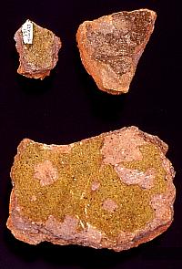
Sherds of Spanish olive jar and green-glazed
wares. These broken pieces of pottery represent types
that are diagnostic of the Spanish colonial era in Texas.
One of the large green-colored sherds is the one that
Kay Hindes found the day the site was discovered in
1993.
|
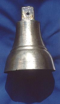
This brass bell, privately owned,
was found in a field near the mission. It likely was
one of the items taken from the mission by the Indians
after the attack.
|
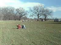
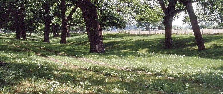
The alfalfa field where the mission
was once located, Fall 1993. Pink flags mark metal artifacts
found with metal detectors. About a quarter of the metal
artifacts were from the eighteenth century, things like
musket balls, wrought iron nails, and brass objects.
Most of the metal was modern: barbed wire staples, ring
pulls, bottle caps, farm machinery parts, and ear tags
from Judge Lyckman's goats, labeled "O. Lyckman."
|
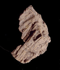
This is one of many pieces of fired
daub that were found at the mission site. The temporary
buildings erected at the mission in 1757 were made of
wattle and daub, the walls being wooden poles stuck
into the ground. The chinks between the poles were filled
by pressing daub (mud) into them. The daub was strengthened
by the addition of grass. When the mission was set on
fire, the wood burned, but the fire-hardened daub survived.
This daub specimen preserves impressions of the grass
that was mixed in to strengthen it.
|
|