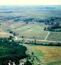
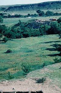
Aerial view looking southeast across
the Wolf Creek Valley. The locality known as Courson
D is near the center of the picture. Photo by David
Hughes.
Click picture to enlarge
|
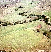
View looking north of the Kit Courson
house (center foreground). In the background is a small
tributary of Wolf Creek. Photo by David Hughes.
|
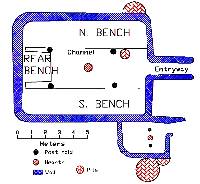
Schematic drawing showing layout
of the Kit Courson house as interpreted by David Hughes.
|
|
Buried City proper is part of a dense settlement
zone along Wolf Creek that spans the space from the upstream
exposure of the Ogallala formation to the place where the
valley widens out, and springs from the Ogallala vanish into
the deep sands of the valley floor. This is a distance of
somewhat less than five miles along a valley that is less
than one mile wide. The stone-based structures are distributed
along the high terraces of this valley every 80 to 150 meters
(87 to 163 yards) and are clustered in possible village arrangements.
These village arrangements are called "groups" here,
like the Buried City/Handley Ruins group, the Moorehead group,
the Courson group, and the Kit Courson group. The nearest
modern comparison would be to a rural subdivision with single
family homes on 5 or 10 acre tracts.
Buried City houses are not multiple-apartment
dwellings intended to house a score or more of individuals
as did the pueblos of the Southwest. They are not the very
large earth lodges the Pawnee used to house large extended
families. But they are substantial houses — and large enough for
small extended families of up to 20 people and spanning perhaps as many as three
generations. The Kit Courson
house measured about 8-x-10 meters (26-x-33 feet) with an interior floor
space of about 63 square meters or 665 square feet (not counting
the small alcove). This seems mighty small for 15 to 20 people
by today's standards, but is consistent with what is known
of village life in native America.
No houses have been found on the floodplain
or first terrace of Wolf Creek. All are located on more elevated
terraces, probably for several obvious reasons. First and
foremost is the need to avoid or lessen the hazard of the
periodic flash floods that Texas Panhandle creeks and rivers
are notorious for. It doesn't rain very often, but when it
does it often comes down quickly and heavily. By locating
the houses above but near the floodplain, Buried City dwellers
would have been able to keep a close eye on horticultural
fields as well as on the overall valley. Being below the caprock,
the house locations would have had some natural shelter from
winds and weather. A final pragmatic consideration might have
been a desire to get above the "bug zone." In wet
times, the valley bottom along the creek would have been marshy
and a good habitat for mosquitoes and gnats.
In all, this short 5-mile stretch of the
Wolf Creek Valley may have had 100 or more of the large prehistoric
houses characteristic of the Buried City. There are other
kinds of houses that did not have the stone foundations,
such as pithouses, that are not included in this assessment
of the settlement pattern. Some of these may date before the
main Buried City settlement or they may be contemporaneous
and represent a part of the settlement pattern that is not
yet understood. The ongoing work by the University of Oklahoma
promises to shed light on this problem.
|
View looking north across Wolf Creek
Valley taken from Courson B. Courson A excavations are
in progress in center of photo. Photo by David Hughes.
|
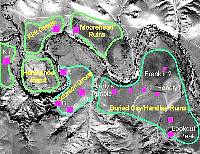
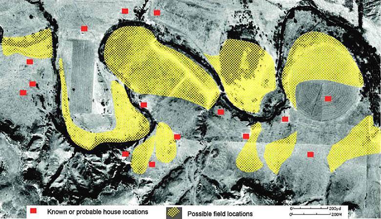
Settlement areas and locations of
major site groups in the Buried City locality. The pink
squares mark the known or inferred location of the most
substantial architectural ruins or houses. Dozens of
less obvious and more deeply buried dwellings and other
cultural features are known or suspected to exist within
each of the settlement areas outlined in green. Base
photo was taken in 1937 by the USDA Soil Conservation
Service. The graphics were added by David Hughes.
|
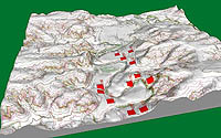
Three-dimensional rendering of view
up the Wolf Creek Valley. The red rectangles mark Buried
City house locations and show the relationship of the
houses to the valley topography. Graphic by David Hughes,
using Maptech software.
|
|