The Hinojosa site was found in 1974 by archeologists from the Center for
Archaeological Research at the University of Texas at San Antonio (CAR-UTSA)
. They were surveying several properties that were to be affected by flood
control projects planned by the Soil Conservation Service. The campsite was
designated 41JW8, the 8th formally recorded archeological site in Jim Wells
County. The site was later named the Clemente and Herminia Hinojosa site
after the former landowners, but became known to archeologists simply as
the Hinjosa site or just JW8.
The following year a research team from CAR-UTSA spent a week evaluating
the site by digging a dozen 2-x-2-m test pits. This testing revealed what
appeared to be a single-component site (i.e., one occupation period)
dating to around A.D. 1300-1400. Preservation conditions were found to be
unusually good for the region; animal bones in particular were very numerous
and in excellent condition. The finding of a large cluster of bison and other
animal bones termed the “bone bed” led CAR Director, Dr. Thomas R. Hester,
to hypothesize that the Hinojosa site was mainly a bison hunting camp
seasonally occupied during the winter to early spring over a few years or
decades at the most.
The site was recognized as an important and significant locality that
preserved evidence of a little-known chapter of prehistoric life.
Because of its research potential, the Hinojosa site was nominated and
subsequently placed on the National Register of Historic Places. Because
the planned flood control work and long-term inundation threatened the site,
the National Park Service’s Interagency Archeological Services-Denver
contracted with UTSA-CAR to carry out additional investigations.
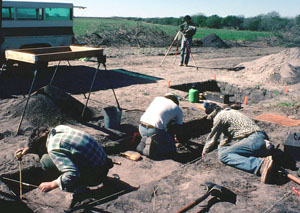
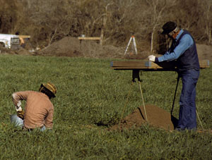
In the fall of 1981 and early winter of 1982 a crew of six archeologists
from CAR-UTSA carried out major excavations over a several months.
TBH editor Steve Black, then a young professional archeologist and
part-time graduate student at UTSA, ran the dig. The analysis and
reporting of the site was Black’s Master’s thesis project and was
published by the CAR-UTSA in 1986. Sections of the report are linked
throughout this exhibit.
To learn more about the history of the work at the site, read Chapter
1 of the site report, Introduction  .
.
The excavations were aimed at addressing a series of research problems or
questions, some of which targeted basic site characteristics (limits, depth,
dating, etc.) and some targeted narrow site-specific questions (nature of
the bone bed, seasonality, bison hunting hypothesis, etc.). The big-picture
problem was to explain how the Hinojosa site fit within regional Late
Prehistoric cultural patterns. By today’s standards in 2006, the research
design was not very sophisticated, but for its day it was a useful and
fairly explicit set of research problems. To learn more about the research
design and strategy, read Chapter 2 of the site report, Research Design.
We began the 1981 field season by carefully mapping the site, relocating
the earlier work, and carrying out additional testing to determine where to
locate the main excavations. Although only six years had elapsed since
the 1975 work, the test pits had been dutifully back-filled, fences had
been moved, and an old dirt road had been abandoned and reclaimed by dense
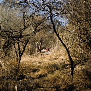
white brush. We hoped to return to the bone bed area and excavate the
surrounding area, but a massive colony of leaf-cutter ants had taken over
the area, perhaps drawn to the softened deposits created by the 1975 test
pits.
So instead the major excavations were carried out some 100’ (30 m) to the
north where promising intact deposits were encountered. This spot was
centered on an old fence that had long separated the agricultural field
from the brush and tree-choked banks of the creek. This boundary proved
fortuitous, because the plowing had stopped just short of the fence—within
the field the site deposits had been churned by decades of plowing. The
abandoned dirt road had run just inside the fence, which led us to give the
major excavation block the somewhat euphemistic name the “Wagon Trail Area.”
Our excavations followed and sometimes improved upon standard field
methods. These are detailed in Chapter 3 of the site report,
Research Methods. As we encountered intact
features, such as cooking hearths and clusters of discarded animal bones, we
expanded the “Wagon Trail Area” excavations to form an excavation block that
eventually measured 6-x-6 meters with two adjoining smaller blocks. The
combined wagon trail area totaled about 52 square meters. We were able to
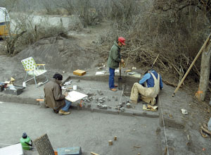
open up a modest-sized excavation area on the edge of the bone bed area
before realizing the full extent of the leaf-cutter ant depredations. We
documented part of an intact layer of occupation debris we called a “living
surface” and we surmised that this would have been a good area for broad
excavations had it not been for the pesky ants.
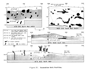
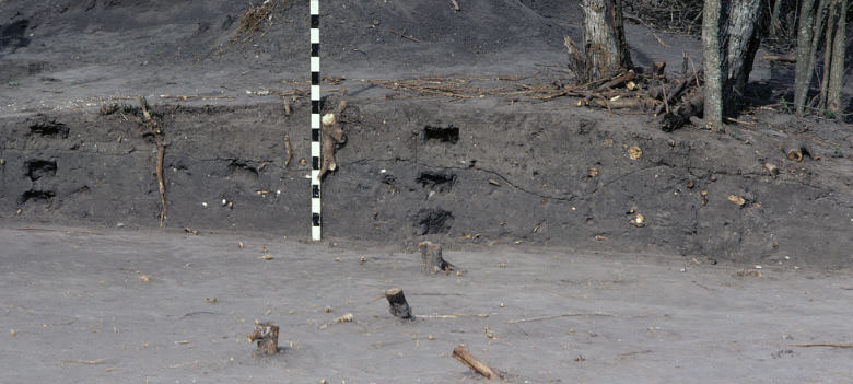
The stratigraphy in the area of the main excavation block was
uncomplicated. At the surface was a light-colored plow zone (Zone 1) of
varying thickness below which was a darker-colored sandy clay layer (Zone 2)
with no visible internal layers. Zone 1 had been churned (disturbed) by
plowing and had no intact features, but some displaced artifacts. Zone 2
had intact features and numerous artifacts—this was the main occupation zone.
The darker color was caused by higher levels of organic material, such as decayed
leaves and, especially, decayed organic materials left behind by the site’s former
inhabitants (food debris, sticks, worn-out sandals, tattered fur, and a hundred
other discarded and abandoned things made of perishable materials).