Site Setting: Place and Time
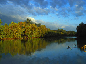
Aerial photograph showing site vicinity as it appeared at the time of the excavations. Note the Colorado River east of the site and timeline showing approximate period of site occupations. |
|
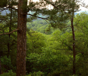
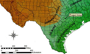
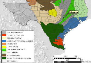
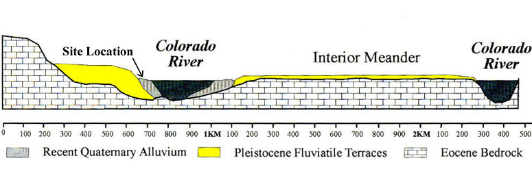
The McKinney Roughs site occupies a small knoll lying on a floodplain terrace of the Colorado River in northwestern Bastrop County. The surrounding area within the juncture of several major physiographic regions including the Gulf Coastal Plain to the south and east and the Edwards Plateau to the west. The site area is within the Post Oak Savannah, a north-south trending biotic zone. In the big picture, the Post Oak Savannah can be seen as a transitional zone between the humid Eastern Woodlands and the more arid lands to the west. Approximately 20 miles to the northwest, the Balcones Escarpment marks the edge of the rugged Edwards Plateau. Just east of the site lie the "Lost Pines," an isolated forest of Loblolly pine trees separated by nearly 100 miles from the Pineywoods of east Texas. Some botanists attribute the pines of Bastrop County to the occurrence of a soil type favorable to their growth—the Carrizo sands—that outcrop over a small localized area. Prehistoric sites are often found along the riparian corridors of rivers and creeks where concentrated plant and animal resources provided a strong economic basis for life. The Colorado River, which originates on the Southern Plains and winds through central and southeast Texas and onward to the Gulf of Mexico, is located only several hundred yards to the east of the site. Here native peoples would have found abundant aquatic resources, such as fish and freshwater mussels, as well as the many birds, deer, small mammals, and other forms of wildlife that depend on the river. The diverse range of trees and native plants growing near the site today would have provided food sources for prehistoric campers, including nuts—pecans and hickory—and geophytes, plants with roots, tubers, and bulbs useful for food, such as cattails, wild onions, and wild hyacinths. Animal life is also abundant and would have been more so prior to highways, fences, and agricultural clearing. Historic-period Indians travelled this area as well. Near the site, the Colorado flows to the southwest in a prominent meander named Wilbarger Bend after one of the area's early historic Anglo settlers, one of the fortunate, or maybe unfortunate, survivors of a Comanche scalping in 1833. In the vicinity of the site, the river valley has deeply cut into ancient bedrock. Around 4000 years ago or so, after meandering across the valley, the river settled into its approximate current channel. Flood deposits of silts, sands, and clays gradually filled the valley. From time to time between major floods, small prehistoric groups would camp on a small knoll along the river for a few days, then abandon their camp. What remained behind was soon buried by flood sediments, forming the successive layers of the archeological record of the McKinney Roughs site. |
|
|
|
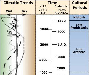
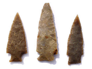
The blend of plant and animal resources afforded in the ecotonal setting—a transition area at the juncture of physiographic regions—played an important role in the nature of prehistoric occupation. Further, the physiography of the area was such that it became a natural corridor for cultural exchange. In 1948 noted archeologist and ethnohistorian Alex Krieger hypothesized that the "Gilmore Corridor," a logical travel route through the Gulf Coastal Plain, northeast Texas and far beyond, had served as the primary route of cultural interchange between eastern North America and Mexico. The hypothesized interchange has never been substantiated, or at least not directly along the Gilmore Corridor, but the idea remains viable and intriguing. A main prehistoric route through the Gilmore Corridor likely would have coincided with what would later become known as the Camino Real, or Old San Antonio Road (now State Highway 21/71), which passes several miles south of the site. In early historic times, the historic trail was called the Camino Real de los Tejas, a reference to the Caddoan peoples of northeast Texas after whom the state was named. In Late Prehistoric times there is considerable evidence that Caddo groups traded with peoples to the west in central Texas. By the mid-17th century, this ancient trail became a camino real, a royal road (trail, really) between colonial capitals on the northern frontier of the Spanish colonies. Although no direct evidence of trade or distant connections was documented at the McKinney Roughs site, its location near the ancient trail suggests that the peoples who camped there would have been aware of, and perhaps in some ways connected to, far away cultures. When Was the Site Occupied?Native peoples camped at the McKinney Roughs site long before the coming of the Spanish. The main period during which the site was used was about 800-2000 years ago, during what some archeologists call the Transitional Archaic period. As the name implies, this period represents a time of change at the end of the long Archaic era, which began some 10,000 years ago (8,000 B.C.). Around 800-1000 years ago (A.D. 1000-1200), the introduction of new technologies (bow and arrow weaponry and pottery making) marks the beginning of the Late Prehistoric period. Period classifications such as these are parts of a larger time scheme (cultural chronology) developed by archeologists as a framework used to help understand regional cultural patterns and changes in human lifeways over time. In Texas, the Archaic era spanned 9000 years, from approximately 10,000 to 1000 years ago (8,000 B.C. to A.D. 1000). Over this immense span of time, people lived in relatively small groups, obtaining their livelihood directly off the land and moving frequently during the year. This mobile lifestyle is known as hunting and gathering or foraging. As populations increased through time during the Archaic, more localized cultures formed and groups lived in smaller territories. Through time, plant foods assumed greater importance in the Archaic diet and people learned specialized preparation techniques to render edible many plants that most of us today would find strange, such as bitter roots. But hunting was always important, especially deer hunting, the number one prey in most areas of Texas except in the Southern Plains and during times when bison herds migrated into the central and southern parts of the state. Archaic deer hunters made many different styles of barbed, broad-bladed, chipped-stone dart points which they propelled with the atlatl, or spear-thrower. In Texas, the Late Prehistoric period saw the adoption of a wholly new weapon technology—the bow and arrow—and the introduction of clay pottery. In many, perhaps most, ways the basic lifestyle remained hunting and gathering. Peoples in other parts of Texas, such as both east and west Texas, adopted agriculture, but in the central part of the state hunters and gatherers held their ground. Here hunting and gathering proved to be a highly successful lifestyle that was followed for at least 13,000 years and only ended when European peoples intruded in the 16th and 17th centuries. Although some evidence dating to the Late Prehistoric period was found at the McKinney Roughs site, most of the evidence there represents only the final part of the Archaic, representing a time about 1000 to 2000 years ago. Chief among the time-marker artifacts found at McKinney Roughs are Ensor dart points and even smaller points made slightly later in time. These smaller points, called Darl, have been considered to be among the last dart points prior to the innovation of the bow and arrow weapons system. Arrow points are characteristically much smaller and lighter than dart points. Given the relatively small size of Darl points, some researchers suspect this style may be an early form of arrow point. Were Darl points used to tip arrows or darts? We may not ever know for certain unless a hafted Darl point is found attached to a wooden dart or arrow shaft. Such finds are only possible in dry cave deposits, which are only found in the west half of Texas outside the main area where Darl points occur. Radiocarbon assays helped establish dating for the site. The layers containing Ensor points at McKinney Roughts were radiocarbon dated to roughly 100 B.C. to A.D. 200 (1800-2100 years ago) during the early part of the Transitional Archaic period. In contrast, the Darl component dates to about A.D. 1100-1150, making this one of the latest occurrences of this style known in the region. The Transitional Archaic period saw the return of more moist climates to the region following a lengthy dry period. More frequent rains caused periodic floods on the Colorado River and—importantly for McKinney Roughs—frequent overbank deposition of sediments which covered over the campsites. These processes served to preserve the layers in the site and allowed researchers to view relatively intact living surfaces. |
|