Discoveries and Investigations
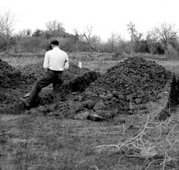
Texas Memorial Museum geologist Glenn Evans conducted excavations at the Keeran site in 1951. Here he works on trenches placed through what he termed "the large mound," which later was determined to be an early Spanish adobe structure. TARL Archives. |
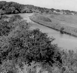
Garcitas Creek flowing beneath what was then a brush-covered bluff at the Keeran Ranch, prior to clearing for1951 excavations. The area to the right later was thought to be the site of the Spanish mission. TARL Archives. |
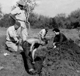
Unidentified workers at the Keeran site during TMM excavations. The field work uncovered thousands of artifacts and traces of what Evans believed were structures. Like many other investigations of the time, only scant records were kept during the project, hampering later work at the site. TARL Archives. |
|
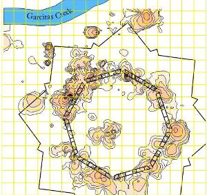
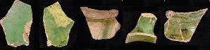
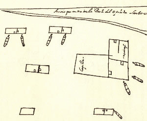
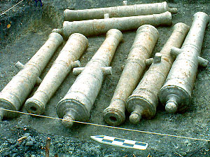
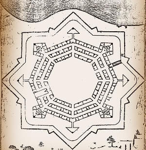
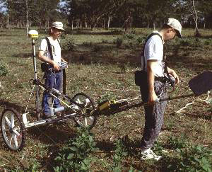
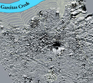
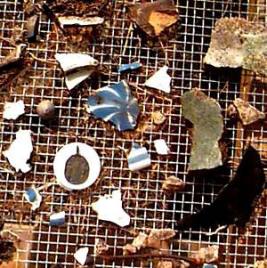
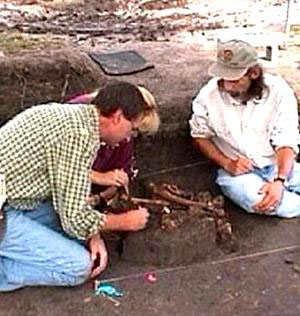
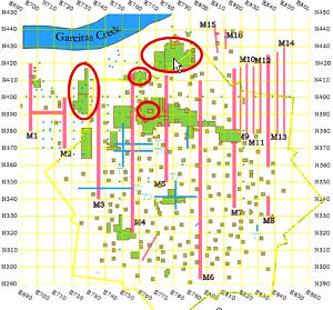
Continuing questions about the Garcitas Creek location were addressed in 1950 when geologist Glenn Evans of the Texas Memorial Museum in Austin was hired to investigate the site, which by then had been named after landowner, Claude Keeran, and been given the official site trinomial 41VT4. Over a period of roughly three months, Evans and a small crew cleared cacti and brush off a large area and dug a series of trenches and excavation units to try to understand the nature of the deposits. The workers encountered large concentrations of historic European refuse—glass and ceramic fragments, hand-made bricks, lead musket balls, gun parts, rusted knives, lead seals, a silver medallion, copper utensils—as well as Native American objects, including arrow points, stone pipes and pottery. Of particular interest were what Evans described as the remains of packed-earth house floors. These features were given fanciful names derived from artifacts: “Ring House,” “Coral House,” “Slate House.” Having uncovered thousands of artifacts and what he believed were the remains of several structures, Evans was confidant he had proven the location of the French fort and the Spanish presidio at Garcitas Creek. Unfortunately, perhaps because funding ran out for the project, the artifacts were not analyzed and a report of findings was never issued. Debate over the location of Fort St. Louis continued for another two decades. In the early 1970s Ed Jelks and Curtis Tunnell of the Office of the State Archeologist approached Kathleen Gilmore about analyzing the pottery and other materials excavated earlier from the Keeran Site. Gilmore had recently completed her master’s thesis on the San Xavier Missions, and she had developed a keen interest in the Historic Period of Texas. With hopes of settling the issue of the identity of the site, the Dallas archeologist took on the task of searching through the thousands of artifacts recovered from the 1950s excavations for remains of the French colony. Mindful of the difficulties in sorting 17th-century European manufactured goods, she determined to concentrate on the pottery from the site. It seemed probable, she later stated in her report, that French ceramics of the time period could be more effectively isolated from Spanish ceramics than could other kinds of artifacts, such as French guns and gunflints that could have been traded and used by others than the French. Amid hundreds of fragments of Spanish blue-and-white majolica and other pottery, Gilmore found several dozen green-glazed sherds, unlike anything she had seen before. A Canadian researcher concurred with her opinion that they were French rather than Spanish—a clear indicator that the site was La Salle’s settlement, Fort St. Louis. In her 1973 report, Gilmore presented her findings, comparing them to conceptual models she had set forth of what the French and Spanish occupations should look like. Over the next several years, she became more convinced of what she had found and published an article in the Bulletin of the Texas Archeological Society establishing the significance of her analyses. Subsequent archeological investigation would benefit from archival research that uncovered other important documents. The map and journal that Bolton had relied on were from the third Spanish expedition to have visited the site. The first, led by General Alonso de León in 1689, had discovered the remains of La Salle’s colony several months after the Karankawa attack. The Spaniards had made a rough locational sketch of the French buildings and eight cannons; they also had buried the remains of three French settlers. Thirty-three years later, fearful of further French incursions, provincial governor Marqués de San Miguel de Aguayo embarked on an expedition to shore up the east Texas missions and to establish the presidio Nuestra Senora de Loreto de la Bahía on the site of La Salle’s colony. According to Spanish records, work on the new presidio had been undertaken in the spring of 1722, based on an elaborate design ordered by Aguayo. Both the 1689 sketch map of the French buildings and cannons, and Aquayo's 1722 plan map of the presidio, would become critical clues when, in 1996, a Keeran ranch employee uncovered portions of an iron cannon near the area of the 1950s excavations. A Texas Historical Commission (THC) crew led by the agency’s executive director, Curtis Tunnell, investigated the find and made an even more remarkable discovery: seven additional cannons. The number matched those depicted in the sketch map made by the Spanish more than 300 years earlier. They were clearly the cannons La Salle’s crew had salvaged from the wreck of the ship, Aimable, and brought inland to guard his fort, the same ones discovered, documented, and buried by the Spanish. The location of La Salle’s Fort St. Louis was no longer in question. Facing ChallengesInterest in the small site remained high, and in 1999 a major investigation that was to span two and a half years was launched at the site by the THC. The investigators hoped to determine the nature of the deposits at the Keeran site and to weigh the accuracy of historic accounts against what lay in the dirt. According to THC Project Director Jim Bruseth, the archeologists anticipated several complicating problems from the outset. Because the Historic Period occupations at the site had been relatively short—spanning only a few decades—there would likely be relatively low artifact density. What artifacts there were would likely be mixed, because the site had been repeatedly disturbed. Further, native coastal people had pillaged the site following their attack on the French settlers, and the Spanish had razed and burned the remains of the structures, reportedly taking everything of value back to Mexico. In more recent times, collectors had periodically visited the site, digging holes and removing untold numbers of artifacts. The 1950s excavations, although conducted in a more systematic approach, had been only scantly documented and sediments were not screened. Artifacts had been catalogued with only a general provenience according to unit. Historical accounts were used to guide the THC investigations, but these resources also raised questions. A journal from the Aguayo expedition told of the construction of the presidio directly over the ruins of the French settlement. The Spanish plan map of the presidio depicted three concentric rows of buildings of buildings surrounded by a complex, 16-point star-shaped palisade wall. To the researchers, the elaborate design seemed grandiose, given the presidio’s remote location. They wondered whether the elaborate fortification actually had ever been constructed, or if the map had been simply a propaganda ruse to deceive hostile governments about Spanish strength in the area. Once test excavations were underway, however, archeologists realized that perhaps the most problematic challenge of all was the dirt itself. The soil in the area was a heavy clay which, particularly during times of drought, was hard packed and homogenous. According to one archeologist, it was like “digging through concrete.” Worse, they found it nearly impossible to discern subtle changes in soil color and texture which might indicate human activity. Further, there had been little accretion, or build up, of soil over time at the site, meaning that artifacts and traces left by earlier cultures potentially were mixed with those of later peoples. As summed up more graphically by archeologist Jeff Durst, “The surface that La Salle stood on was the same that prehistoric Indians stood on 5,000 years before.” Surveying Beneath the SurfaceTo address some of these problems and gain a better understanding of what lay underground, a magnetometer, or remote sensing, survey was conducted. This rapid survey method entails dragging a wheeled cart holding magnetometer sensors across the surface of a site. Capable of taking up to 10 readings per second, the instruments detect magnetic disturbances below the soil surface that may have been caused by past human activity, such as digging post holes or pits for fires or trash. In Historic Period sites, iron and other ferrous metal also can be detected. These various data are compiled into computer maps of magnetic patterns, providing a means of “seeing” beneath the surface to determine the size and layout of sites, even before a single shovelful of dirt is dug. The first magnetometer survey covered the roughly 4-acre area that had been investigated by Evans in the 1950s. The resultant maps showed an intriguing and complex set of anomalies, ranging from large concentrations of disturbances to small dipole anomalies characteristic of ferrous metal scattered across the site. On gray-scale computer maps, dipoles appear as black and white spots, representing both high and low ends of a magnetic pole. In one area, the small dipole signals formed a clear pattern, a roughly circular ring measuring about 88 yards (80.5 meters) in diameter. When compared to the Aguayo map of the Spanish presidio, the magnetic ring seemed to correlate to the concentric rows of structures encircling a central parade ground, or plaza. Using this information, the archeologists began small test excavations to determine the nature of the anomalies and obtain a sample of artifacts. A number of Spanish colonial artifacts, including metal, burned clay, and sherds of blue and white Spanish majolica dishes was recovered. This diverse range of artifacts likely represented trash that was dumped by the Spanish soliders outside their huts. Unfortunately, no traces of structures were discovered during testing. For this reason, the THC archeologists decided to use artifact patterns to guide their search. Digging inside the ring area, they found a series of postholes and stains as well as large amounts of trash, including a number of iron artifacts. They excavated quantities of burned clay, which they believed was daub. According to Spanish accounts, a series of jacal buildings had been constructed to house the soldiers. The jacales had been made of upright wooden poles set into the ground and covered over with clay to seal out moisture and provide insulation. The main difference between what was found in the excavation and what was depicted on the historic map was that there had been only a single ring of jacal buildings, rather than the three circular rows shown. Once the building remains had been located, the archeologists began their search for the remains of the star-shaped palisade fence depicted on the map. The magnetometer survey had failed to detect signs of this elaborate feature, likely due to a lack of magnetic contrast in the clay soils. By superimposing the map of the presidio onto the magnetometer map, however, the investigators could more accurately determine the scale for the presidio and estimate the distance from the jacales to the palisade. This gave them a more precise starting point to begin searching for the remains of the palisade trench. Since there was no way to know the correct orientation of the Spanish map in relation to the site, however, there were countless possibilities for locations of individual wall sections, depending on the rotation of the 16-point star. |
|
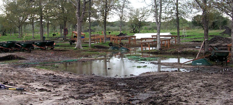
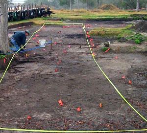
Excavation units, inundated with rain water. Following months of drought, the torrential rains proved to be a mixed blessing for excavators. Although water had to be pumped out of the site, the dampened soil finallyenabled archeologists to discern traces of structures. |
Months of excavation ensued with no success until a series of rains ironically broke both an area drought and the archeologists’ “dry holes.” Moisture from the rains made subtle contrasts in the soil horizons more visible, enabling crewmembers to detect a dark, linear soil discoloration in one of the excavation units. On closer inspection, the darker area proved to be a series of post molds. More digging revealed additional sections of the original Spanish setting trench and the discovery that the palisade had, indeed, followed the exact 16-point star shown on the map. Roughly in the center of the compound area, crews found the remains of an adobe structure. Intact portions of mortared walls coated with plaster and charred fragments of the wooden roof were uncovered in what had been the building interior. A surface of “shell hash” had served as an entryway into the structure, of service particularly during rainy periods. Clues to the French SettlementIf historic accounts were correct, the remains of Fort St. Louis should lie underneath the presidio, or in close proximity. Excavators probed the clusters of magnetic anomalies to the north, generally outside the ring of the main presidio area. These dipole signatures turned out to be metal artifacts, including quantities of slag, pieces of cut copper, and thousands of small iron fragments. It appeared they had found an intensive activity area—likely the spot where the French colony’s blacksmith had worked refurbishing copper kettles, making iron tools from iron bar stock, and other materials needed in the settlement. There also were large quantities of charcoal, which likely had come from his forge. Just to the south, hundreds of other French artifacts were found—distinctive French gunflints, lead shot, trade goods such as glass beads, and pottery sherds. The remains of the setting timbers of two walls of a structure also were found, and these correlated to the crude map of the French fort drawn by the De León expedition in 1689. The diary of La Salle’s lieutenant, Joutel, indicates the structure was built in an L-shape design, using sturdy timbers salvaged from the Aimable. The archeologists also uncovered traces of the French chapel, and several smaller dwellings. Once the excavation data were overlaid on the magnetometer map, clear conjunctions were evident. Most Spanish artifacts were located in the perimeter of the presidio complex. Materials related to the French occupations lay to the north, although some features had been covered over by the construction of the presidio. Traces of aboriginal pottery, chipped-stone tools, and other non-European artifacts roughly encircled the presidio complex, suggesting coastal peoples—likely the Karankawas—had camped outside the stockade, perhaps to engage in trade with the soldiers. Three BurialsExcavations at the Keeran site conclusively established the location of La Salle’s settlement and the later Spanish presidio. What still remained a mystery, however, concerned the remains of the numerous French settlers who had died at Fort St. Louis, either at the hands of the Karankawa or because of disease and other deprivations. In November 2000, archeologists uncovered the skeletons of three individuals. The skeletal remains were disarticulated, suggesting they had lain exposed to the elements for some time prior to their burial. Based on analysis by R. Gil King of North Texas University, one skeleton was that of a white female, 25-35 years in age; a second was a male, 30-45 years old, and the third a boy, somewhere between 7 and 10 years old. The female had suffered a massive blow to the skull. The adult male had two blunt force injuries on his skull as well as a perforation injury. A study of the teeth of the adults showed changes in the enamel caused by either periodic bouts of malnutrition or infections that sapped protein from the body. There also were indications the adult male had suffered from syphilis. It appears fairly certain that these three skeletons were those discovered—and subsequently buried—by members of the De Leon expedition in 1687 while doing reconnaissance at the ruined French settlement. Their accounts describe finding three badly decomposed bodies—a woman and two men—lying in a field near the chapel ruins. The woman had been shot in the back by an arrow; fragments of her dress still clung to her bones. The Spaniards said mass over the remains and buried them, an experience which moved one soldier, probably expedition historian Chapa, to pen a poem about the woman who had been so cruelly murdered in the Texas coastal wilderness. It is possible she was Isabelle Talon, mother of several children in the colony. Although accounts indicate more than 50 colonists died at the settlement, no other burials or remains of a cemetery were found. During the three-year investigations, THC archeologists mounted an extensive search and survey over a broad area, testing and trenching a roughly 40-acre area. Most archeologists involved in the search believe it highly unlikely they would have missed a cemetery area if it were in reasonable proximity to the settlement. There are several theories, however, about why no other remains were found. One is that the dead were buried near the edge of the bluff overlooking Garcitas Creek. Over the course of some 300 years, trees may have been uprooted naturally and fallen over after heavy rains, causing the bluff edge to cave into the creek. According to Durst, several large oaks met such a fate during the time they worked at the site. Other THC researchers believe that, because the settlement was never intended to be the permanent site for the colony, a cemetery was never established and that the bodies of individuals who died there may have been weighted down and deposited in the river for disposal. Finally, some local historians believe that there was a cemetery, and it remains to be discovered. One other element of the site eluded archeologists: traces of Mission Nuestra Señora Espíritu Santo del Zúñiga that, according to reports, was established in 1722 across the creek from the presidio and the site of Fort St. Louis. Here Spanish priests set out to christianize and convert the local Indians. Just as the French had failed in growing crops, so did the Spanish and their native charges. Throughout, the Karankawa resisted this effort and violence ensued. Scarcely a year passed before the misison was moved inland to a more favorable site on the Guadalupe River (see TBH exhibit on Mission Espíritu Santo to learn more). Across Garcitas Creek, scatters of Spanish artifacts were found but no definitive evidence of the mission, and this may have been due to the brevity of its presence. In the End |
|

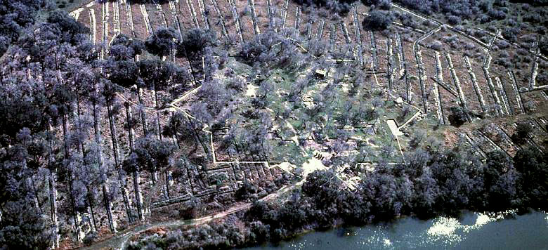
Aerial view of the site near the end of multi-year investigations. Garcitas Creek is shown at bottom. Excavation units and trenches have been outlined with plastic tape, as has the outline of the 16-point-star-shaped Spanish presidio, which was built by the Aguayo expedition on the site of La Salle's ruined settlement in 1720. From this vantage point, the site of Fort St. Louis is at the edge of the trees overlooking the creek. The many parallel lines are the trenches dug across the site during the archeologists' intensive but unsucessful search for the French colonists' cemetery. Photo courtesy of THC. |
|
Spanning two and a half years, the investigations at the Keeran Ranch site uncovered a wealth of information about La Salle's settlement and the Spanish Presidio La Bahía, bridging the gap between 300-year-old documents and what was left behind in the dirt. Excavators confirmed Henri Joutel's descriptions of the French structures as well as the layout of the little settlement shown in the map drawn by the De León expedition. Archeological evidence also bore out Spanish accounts of burying eight French cannons as well as the bodies of French settlers killed by the Karankawa As regards the Spanish occupation, the archeological work confirmed that the presidio had been built according to the elaborate plan drawn by the Marqués de Aguayo and had been garrisoned with soldiers to guard against the return of the French. Traces of the Karankawa were found throughout the site as well, raising intriguing questions. Distribution of native artifacts strongly suggested that the Indians had not only traded with the French but lived just outside—if not within—the walls of the presidio during the time of the Spanish. Project archeologist Jeff Durst notes that the unusual length of time spent excavating allowed for continual reassessment of findings in the field. "We had different interpretations of what we were seeing as we went along, changing about every three weeks as we made new discoveries. We looked for the Spanish palisade wall trench for about a year before we found it. We had begun to think that the Spanish map of the presidio with the 16-sided wall was just propaganda put out at the time. Had it not been for that extra length of time we spent in the field, we might never have found it." A comprehensive report of findings from the excavations and analyses of artifacts is being prepared by THC archeologists and contributing researchers. In addition to the technical report, an illustrated book for general audiences also is planned. To learn more about findings and to see examples of artifacts, see Traces of French, Spanish, and Indian Lives.
|
|