Ethnohistory
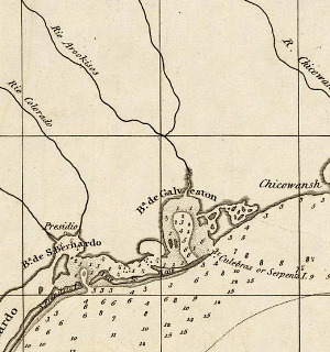
Wild and Cannibalistic Indians. Detail of a 1718 map by the extraordinary French cartographer Guillaume Delisle. Although this map is one of the most accurate and influential maps of the early 18th century, it shows how little New World colonists knew about the upper Texas coast. The coastal plain of today's southeastern Texas and southwestern Louisiana is labeled “Indiens errans et Antropophages” -- wild and cannibalistic Indians. The French explorers of the day (and the Spanish as well) traveled east to west overland well to the north of the coastal plains where numerous rivers, streams, bayous, and marshlands made travel difficult, as did the reputation of the Indians. David Rumsey Map Collection. |
|
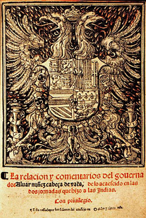
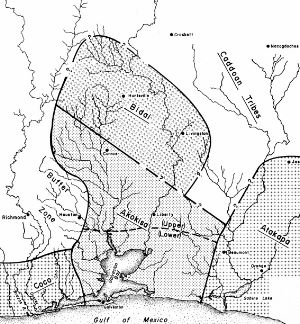
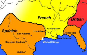
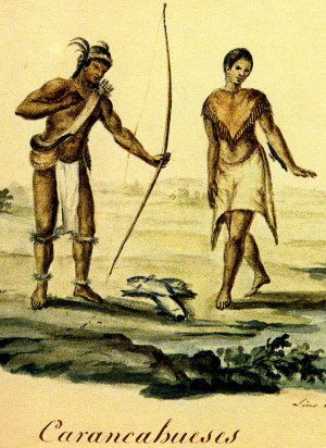
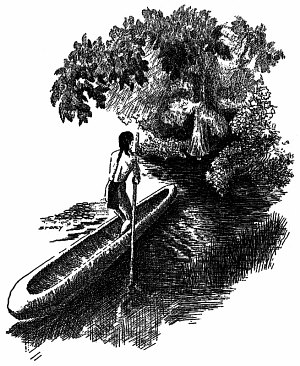
Mitchell Ridge yielded evidence not only of the latest era of prehistory, but also of the early centuries of the known historical record. Indeed, some of the findings made at Mitchell Ridge can be linked to certain recorded events and patterns about as closely as is possible, short of a direct correlation with a precisely documented place or known historical personage. It is somewhat ironic, therefore, that despite a wealth of historical documentation for the relevant time periods, and despite a remarkable set of archaeological data on the Early Historic period occupation at the site, the precise ethnic identity of the native people(s) who occupied the site is difficult to identify with certainty. This situation derives from two factors. First, it is generally the case that non-agricultural foraging peoples characteristically moved about within partially overlapping territories to the extent that fixed settlement locations of named ethnic groups generally cannot be identified in the historical record. Second, the Mitchell Ridge Site is located near the geographic point on the upper Texas coast that served as a boundary zone between two major ethnic/linguistic groupings. Namely, the Atakapa-speaking Akokisa Indians around Galveston Bay and the Karankawa, who reside along the coast between the area of the Brazos River Delta and the Corpus Christi Bay area. The historic documents are rather ambiguous as to precisely where this boundary was situated at any one point in time. The mobile lifeway of aboriginal people in the area may have precluded the establishment of hard and fast territorial boundaries. Three basic periods of Euroamerican-Indian contact/interaction are relevant to the findings at Mitchell Ridge. The first, corresponding largely to what archeologists term the Protohistoric period (ca. A.D. 1500-1700), saw exploration by Spaniards of the Southeast and the Gulf Coast, as well as early Spanish settlement and missionary activity along the coasts of Florida and in New Spain (Mexico). The second period began with the incursion of the French into the Mississippi Valley and the Gulf coast near the end of the seventeenth century. During these years, the French began their exploration of the Mississippi Valley and established a small, ill-fated colony near Matagorda Bay on the Texas coast, ventures which were to open the way to concerted settlement and economic activity in the Mississippi Valley and adjacent areas in the early eighteenth century. In response to the French incursions, Spanish authorities in New Spain, fearing permanent encroachment on their Gulf coastal plain territorial holdings, began to explore the western gulf coast in earnest, and establish a string of missions and presidios, first in northeast Texas among the Caddo, and later at Bexar (San Antonio) and various locales on the Texas coastal plain. The final historical period relevant to our findings at Mitchell Ridge began in the early eighteenth century. During this period, the French settled the Lower Mississippi Valley and adjacent areas, establishing towns at Biloxi, Mobile and New Orleans, as well as trading settlements and military posts in strategic locations such as Natchitoches in present-day western Louisiana. The towns and posts quickly became entrepôts for the far-reaching economic activities of entrepreneurial traders who traveled among native peoples, exchanging European manufactured goods for Indian commodities, most notably deer hides. By the second quarter of the eighteenth century, the deerskin trade had emerged as a southern counterpart to the long-established northern trade in beaver pelts, and many native groups rapidly came to rely on a wide array of manufactured goods acquired from French traders. Spanish Exploration and Settlement in the SoutheastThe Spanish incursion into the Southeast (today’s southeastern U.S.) came from two directions, from the Caribbean as well as New Spain (Mexico). Settlements were established in the Caribbean beginning with Columbus’s founding of La Navidad on the coast of Haiti in 1492. Puerto Rico was initially settled in 1508, and settlement of Jamaica and Cuba began, respectively, in 1509 and 1511. Settlement of New Spain began in central Mexico in the 1520s, and by the 1580s the northern frontier of New Spain had reached as far north as Saltillo and Monterrey, where silver mining operations were established. The northern frontier of New Spain remained more or less fixed for over 100 years. Spanish expansion into what is today Texas began only at the end of the seventeenth century in response to French intrusions—actual or anticipated—into the northwestern Gulf region. On the other hand, Spanish exploration and settlement pushed early into Florida. Ponce de Leon claimed the Florida Mainland for the Spanish Crown in 1513, though the first lasting settlement was St. Augustine on Florida’s Atlantic coast, established in 1565. A number of Spanish expeditions in what is today the southern United States were undertaken during the sixteenth century. Two of the most intensively researched are that of de Soto/Mososo in 1542 and the travels of Alvar Nuñez Cabeza de Vaca, a survivor of the ill-fated Narvaez expedition of 1528. The de Soto expedition began in Florida and traversed much of the upland south, crossed the Mississippi River and ultimately entered the northeastern part of present Texas. Although this expedition did not reach the Texas coast, it may have had serious repercussions in the interior Southeast: the introduction of Old World diseases. In contrast to the situation with the De Soto/Moscoso expedition, Cabeza de Vaca and his fellow shipwreck survivors of the Narvaez expedition lived among native people on the upper Texas coast, beginning in 1528. Cabeza de Vaca lived with a group that frequented a coastal barrier island during part of its seasonal round, and this island may well have been Galveston Island. Whether or not Cabeza de Vaca’s “Isla del Malhado” (Island of Misfortune) was, in fact, Galveston Island, the locale was almost certainly nearby on the upper Texas coast. Thus, Cabeza de Vaca’s observations are highly significant as an early ethnohistoric account documenting the native people of the area and aspects of their lifeway prior to the effects of European colonization of the larger surrounding region. Several observations made by Cabeza de Vaca shed light on basic patterns of native subsistence and settlement. The first contact which he and his party had with native people on Isla del Malhado was an encounter with three Indians armed with bows and arrows. Within a half hour, the Spaniards found themselves facing about 100 men, all similarly armed. Since the ration of able-bodied adult males to total population was probably at least 1:4 among Texas costal hunter-gatherers, a resident island population of several hundred people is implied. This suggests that the island’s resource base was sufficiently reliable and abundant that a relatively large population aggregate could be sustained. Cabeza de Vaca came to know Isla del Malhado and its seasonal residents well as this passage shows:
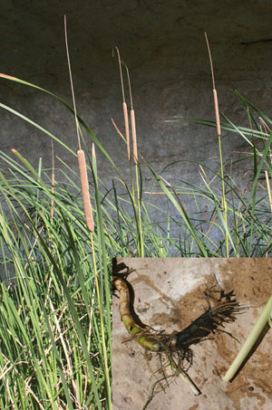
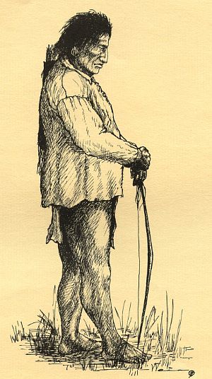
This short passage indicates several fundamental aspects of aboriginal adaptation to the barrier island environment. Clearly, fish were a major staple and were obtained by the use of a specialized technology: fishing weirs. The passage sometimes translated as “channels made of reeds” almost certainly refers to artificial fish traps such as those known to have been used by various North American Indians along the Eastern Seaboard. Although Cabeza de Vaca does not provide details, weirs are most effective when placed in tidal passes during periods when fish are migrating through. On the Texas coast species such as redfish and flounder leave the bays during the late fall and head to the deeper, warmer waters of the Gulf. Cabeza de Vaca said the roots “taste like nuts” and that “most of which are taken out of the water with much trouble.” The identity of these roots is debated, but they were clearly some type of helophytes, marsh plants with surviving buds in the water or mud at the bottom of freshwater ponds such as those near the Mitchell Ridge site. Cattail or bulrush (Typha sp) is one of several plausible candidates. Roots were obviously very important in the diet, and would have provided a high-starch complement to an otherwise protein-rich diet of fish. The Indians spent the fall and winter on the island, but went to the mainland at the end of February to gather shellfish, berries, and doubtlessly to hunt as well. (See Learning from Cabeza de Vaca exhibit.) Little is said about the kinds of houses inhabited by the Indians. They seemingly were simple huts, since Cabeza de Vaca noted that the lodges afforded little shelter against the cold weather, and were covered with mats. The fact that the Indians were able to quickly build a hut for the shipwrecked Spaniards indicates that houses were very easily constructed and well-suited to a mobile way of life. Cabeza de Vaca left a number of nuggets of information concerning the social organization of the island people. He noted that, in general, marriages were monogamous. Exceptions were made for “medicine men” or male shamen, who were permitted two or three wives. Political authority seems to have been weakly developed, since Cabeza de Vaca noted that the Indians had “no ruler among them.” Children were apparently afforded special treatment, since Cabeza de Vaca believed that “of all the people in the world, they are those who most love their children and treat them best…” Shamen apparently were accorded special status; only the bodies of shamen were cremated, suggesting a special set of beliefs associated with the body and/or spirit of the shaman. Cabeza de Vaca’s observations on mortuary practices have special interest for the findings at Mitchell Ridge. His observations indicate that mortuary practices were not uniform, but varied according to social roles and age/sex status. He stated that a one-year period of mourning was commonly followed the death of a member of the group. This may be reflected by the presence of curated human remains at Mitchell Ridge which constituted secondary burials. The mention of cremation of shamans is also possibly relevant to the fact that a minority of the burials at Mitchell Ridge are secondary cremations. Finally, Cabeza de Vaca implies special mourning practices for males (brothers and sons), which may be in keeping with greater status, as suggested by relatively more burial goods in male graves than in graves containing female individuals. Despite the limited economic relations between Indians and Spaniards during the sixteenth and seventeenth centuries, and the limited extent of Spanish settlement and missionary activity, it is apparent that early Spanish exploration and colonization had profound effects upon native societies across the Southeast. The introduction of Old World diseases, for which Native Americans had never developed immunities, dramatically reduced aboriginal population levels, perhaps as early as the middle of the sixteenth century. As a result, the geographic distribution of native societies was, by the late seventeenth century, considerably changed from what it must have been earlier. The disruptions and displacements of native peoples and communities had wide-ranging effects which reached as far as the Mitchell Ridge Site on Galveston Island, as is discussed in the Life and Death section. Initial French Contacts and Spanish-French InteractionBetween the 1680s and the 1720s, European colonists became increasingly active in the western Gulf coastal plain. It was a period of geographical rivalry and confrontation between the French, who pushed southward down the Mississippi Valley, and the Spanish, who regarded the region as the northern frontier of their colonization of New Spain. The first settled colony on the Texas coast was established by Rene Robert Cavalier de la Salle in 1685, which La Salle named Fort Saint Louis. The colony was to prove a short-lived and ill-fated venture fraught with problems from even before its inception. The establishment of Fort Saint Louis greatly alarmed the Spanish and served as a direct catalyst for Spanish authorities to act quickly in two ways. First they commissioned expeditions through the interior of the state and along the coast to determine the extent of French incursions. Second, the Spanish established the first mission-presidio complexes in east Texas in order to block westward French expansion. Over the next few decades the Spanish and French gradually became more familiar with the upper Texas coast. One of the most revealing documents is the account of the Frenchman Simars de Bellisle, who was marooned with four compatriots on the upper Texas coast in the winter of 1719. The general consensus among historians is that these men found themselves on the shores of Galveston Bay. Four of the five soon died of hunger and exposure, leaving de Bellisle as the sole survivor. He, too, almost certainly would have perished had he not encountered a group of coastal Indians with whom he lived for over a year. The account left by de Bellisle of his life with these Indians, most probably Akokisas, is a remarkable record providing useful first hand observations of native life on the upper Texas coast in the early eighteenth century. After burying the last of his companions, de Bellisle first encountered Indians on an island in the early spring, where they were busy gathering birds’ eggs on the beach. The Indians took De Bellisle’s clothes, forcing him to spend the night neck-deep in water to thwart clouds of mosquitoes. Though not seeming particularly sympathetic to his plight, the Indians nevertheless fed de Bellisle and allowed him to remain with the group. It is clear from the account that during the summer the group was quite mobile, moving from place to place to hunt and gather plant foods. De Bellisle describes this pattern as follows:
With the onset of winter, the highly mobile foraging pattern of the summer months appears to have given way to a different sort of residence pattern involving larger groups:
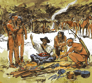
The account shows that hunting was practiced during the winter as well as the summer season. The winter hunting described by de Bellisle was an activity carried out by male hunting parties setting out with the specific goal of procuring meat and then transporting it back to the larger group. Clearly, the four decades between the 1680s and the 1720s saw an increasing European presence along the Texas coast, as exploratory expeditions commissioned by Spanish and French authorities crisscrossed the region and surrounding areas. Native peoples surely must have increasing felt, directly or indirectly, the effects of the growing colonial presences along the Gulf coastal plain. Still, the people of the upper coast remained geographically removed from the more direct impacts of European contact during this period. The Spanish settlement in the form of mission-presidio complexes was yet to come to the Galveston Bay area, and direct participation in the French-Indian trading sphere probably emerged only during the second quarter of the eighteenth century. The French presence in Louisiana and eastern Texas grew rapidly after Louis Juchereau de St. Denis established a trading post on the Red River at what is today Natchitoches, Louisiana in 1713. French traders were soon traveling westward into the eastern frontier of New Spain and developing strong trade relationships with native peoples, especially among the powerful Caddo nations. It was probably not long before native groups in the upper coast area began participating indirectly in the French-Indian trade in deerskins through intermediate groups. Intensified Indian-European Interactions and the Deerskin TradeThe native peoples of coastal Louisiana and the upper Texas coast were probably among the last groups to be directly affected by the European colonization of the Gulf coastal plain. The Atakapa of south-central and southwestern Louisiana were apparently relatively insulated from the main thrust of events further to the east and north, doubtless in part because of the general unattractiveness of the swampy bayous of the region to European settlers. Thus the country of the Atakapas could and did serve as a refuge for remnant Lower Mississippi Valley populations. The native people living to the west in the Galveston Bay area were still further removed from these processes. While the Atakapa-speaking Akokisa had experienced direct contact with Europeans prior to the 1740s, this involved only marooned individuals such as de Bellisle (or de Vaca) or exploratory expeditions that only skirted their territory. And, although the Spanish were quick to respond to French incursions into Texas, the early mission-presidio complexes were established at considerable distances from Galveston Bay, first in northeast Texas among the Caddo (in 1691), then at San Antonio (in 1718) and finally on the coastal prairie well to the south at the various shifting locations of mission Espiritu Santo and presidio La Bahía on Garcitas Creek (in 1722) and then on the lower Guadalupe River (in 1726), and finally at the site of modern Goliad, Texas (in 1749). (See Mission Espiritu Santo exhibit.) By the early 1740s, rumors that French traders were operating in the area began to reach the ears of Spanish authorities. Fearing systematic French incursions into the eastern margins of their domain, the authorities commissioned an exploratory expedition to the Galveston Bay area in 1745 to determine if in fact the rumors were true and if there were any signs of actual settlement by the French in the area. In early 1746, Captain Joaquin Orobio y Bazterra, who was then stationed at Presidio La Bahía on the lower Guadalupe River, led the expedition into southeast Texas. Traveling overland more or less parallel to the coastline, the expedition reached the Trinity River on March 6th at a location some distance upstream from Galveston Bay, in the territory of the Bidai Indians. A number of observations recorded by Orobio y Bazterra provided insight into the status of European involvement in the area:
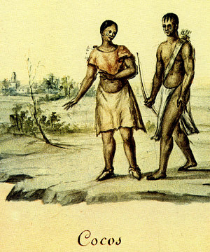
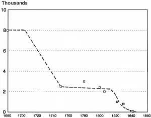
It seems clear that the local native people had little or no direct contact with Spaniards up to 1746. The French, on the other hand, had been trading directly to the Akokisa since at least as early as 1740 by making what seem to have been more or less annual trading expeditions to the upper Texas Coast. It is probable that trade was taking place between Galveston Bay area natives and the French prior to 1740. French traders were operating among the Atakapan groups of the Louisiana coast by the early 1720s, and these activities could well have extended westward along the coast to the Atakapa-speaking Akokisa. Although the expedition led by Orobio y Bazterra found no evidence that the French had actually established a settlement or trading post among the Akokisa, rumors of French activities continued to circulate. In 1754, a Spanish military force was dispatched from Presidio Los Adaes under the command of Lieutenant Marcos Ruiz with 25 soldiers, a force which was to be bolstered by Bidai and Akokisa Indians. In order to win the alliance of the Indians, the expedition was provided with “a superabundant supply of goods for barter to use as gifts… persuade the Indians to help” (1754 report of Don Jacinto de Barrior y Jáurigui, Governor of Tejas). Additionally, the Spaniards promised that if the trading post were located and the Frenchmen captured, the spoils would go to “the chiefs.” (See Los Adaes exhibit to learn more about the 18th-century Spanish capital of Texas and Spanish-French interactions). Ruiz succeeded in wining over the needed Indian allies and the combined Spanish and Indian force reached the French establishment on October 10, 1754. There on the east bank of the Trinity River a few miles upstream from Trinity Bay, the Spanish a trading post consisting of jacal structures including a house and several warehouse facilities. The post was manned by the trader Joseph Blancpain and several assistants. Blancpain and the others were arrested and the French trade goods (plus deer hides that had already been traded for) were given to the Indians. Blancpain was taken to Mexico City, where he was interrogated and told the Spanish authorities that the trading post was intended to be the first stage in a planned French settlement. Determined to prevent a French settlement of the area, the Spanish established the Presidio of San Augustín de Ahumada in July 1756 at the precise location of Blancpain’s trading post. An accompanying mission was built for the Akokisa. Calling the site El Orcoquisac, they made plans to turn it into a civil settlement of 50 families, creating a permanent Spanish presence in the Galveston Bay area. The presence of the presidio hampered local trade between the French and local Indians, but the Spanish were unable to form their own trading relationships with these groups. They often suffered from shortages of basic supplies, leaving little leftover for trade. As a result, the Spanish could only act as middlemen, exchanging goods between the French and Indians. Plans for a permanent settlement faded as the Akokisa showed little interest in living there and the mission-presidio suffered from neglect, turmoil, and lack of supply. The remote outpost was finally abandoned in 1771. (See El Orcoquisac.) Upper Coast Native GroupsDrawing upon information originally presented in the reports of Orobío y Bazterra and others, Lawrence Aten constructed a general model of sociopolitical organization among upper coast populations in his 1983 book. Assuming that the Akokisa and Karankawa had generally similar kinds of adaptation, and noting the fact that the two linguistic groups had adjoining territories, Aten suggested, with due caution, that the fragmentary data available for both groups can be combined to arrive at a general picture of organizational patterns. Repeated references by the mid eighteenth century Spaniards suggest that the Akokisa were divided into several subgroups, each of which was represented by a headman or “chief.” There appear to have been five such groups, with a total population of about 1,200 people. Each headman seems to have been associated with a single “village” or aggregation of small bands. Based on worldwide ethnographic comparisons, each band probably consisted of as few as 25 people. The related bands would have dispersed periodically to carry out various kinds of subsistence tasks and other activities. Noting that individual headmen and their “villages” seem to have shown differing alliances with the Spanish and French, Aten inferred an absence of overarching centralized authority integrating the various Akokisa groups or villages. The villages are suggested by Aten to have been a seasonal phenomenon, with several small constituent bands coming together during fall-winter to form population aggregates of between 100 and 400 people. During these periods of aggregation, the bands were presumably integrated under the leadership of the village headman. During the warm season, the population dispersed into small bands, presumably the kin groups implied by Cabeza de Vaca. Each small group may have practiced the highly mobile subsistence activities described for the summer season by de Bellisle. Authority patterns among the Karankawa groups may have different somewhat from those of the Akokisa. Whereas only village headmen are recorded for the latter group, the Karankawa were said to have had two kinds of chiefs, namely “civil chiefs” and “war chiefs.” Gender roles reflect a similar division of labor to that documented among most hunter gatherer societies. Simplistically stated, men hunted and engaged in raiding and trading, while women did most of the work: plant gathering, food preparation, hide processing, child rearing, and so on. As mentioned earlier, Cabeza de Vaca’s comments also imply a higher status for adult males and children than for adult females. Based on data gleaned for the historic Atakapa of southwestern Louisiana, Aten infers that marriage rules involved virilocal and perhaps patrilineal band exogamy. In other words, it is thought that a man took his wife from outside his own clan or group (exogamy), wives came to live with their husbands (virilocal), and descent was traced through the male lineage (patrilineal). This pattern was probably true for the other Atakapa-speaking groups, the Bidai and Akokisa, and perhaps the Karakawa groups as well. Such practice would have strengthened ties between bands through intermarriage, thus maintaining larger tribal identities. Aten suggests that for the Akokisa and Bidai, the tribe was an organizational unit which was comprised of the several aggregate band or “villages” documented for the eighteenth century. The Bidia and the Akokisa were, then, essentially tribal ethnic entities made up of villages or “macrobands” (closely related bands) held together by a shared territory, a common language and lifeway, and by the mechanism of virilocal band exogamy. Concerning the Karankawa, it should be kept in mind that the name most accurately represents several distinct groups which shared a common language. The groups, known to the eighteenth century Spanish as the Cocoas, Cujanes, Carancaguases (or Karankawa proper), Guapites and Copanes may each have been a tribal entity in the sense used by Aten for the Akokisa and Bidai, since each was probably comprised on several macrobands under headmen, and these were in turn formed on a seasonal basis by the aggregation of several small band groups. Recent archaeological research, combined with surviving historical accounts, suggest that small bands of Karankawa came together seasonally, to form larger residential groups at favored fishing campsites along the coastal bay shores during the prime fishing season, which extended from fall into the early part of spring. The ethnohistorical documents left mainly by Spanish explorers, military personnel and missionaries indicate that the smaller bands generally were made up of around 50 people, while the aggregate shoreline groupings numbered up to 500 individuals. Thus, the Karankawa appear to have maintained a pattern of seasonal aggregation-dispersal of population similar to that suggested by Aten for the Akokisa and Bidai tribes, and as documented by anthropologists for numerous hunter-gatherer populations worldwide. Demise of Upper Coast Native PeoplesThe native populations of the upper Texas coast are poorly documented during the latter part of the eighteenth century, primarily because of the failure of local Spanish settlement and a resultant dearth of direct documentary evidence. Aten’s research has shown that the period saw marked population decline in response to periodic epidemics of smallpox and other diseases. By the late 1700s, the Akokisa’s mid-eighteenth century population of about 1,200 had declined to a few hundred. Virtually all native groups in the surrounding region suffered similar demographic collapses from the effects of epidemics and pressures exerted on traditional territorial boundaries by Euroamerican incursions. Ricklis� studies of historical documentation pertaining to the Karankawa suggests that, at the time of French incursion into their territory in 1685, the several Karankawa tribes had a combined population of around 8,000, and that this declined dramatically to around 2,500 by the middle of the Eighteenth Century. Surviving native peoples were dislocated, forced to move away from growing American settlement across the Southeast. Mergers took place between previously separate sociocultural groups (independent bands), resulting in what Aten has called composite bands. Remnants of some native populations in the Lower Mississippi Valley sought refuge among the coastal Atakapa. Within the boundaries of what is today Texas, the late seventeenth and eighteenth centuries were highly dynamic and volatile, as southward-moving Apaches, Comanches, and other groups displaced local populations. Indigenous survivors of the various epidemics were pushed out of their traditional homelands, or joined other groups, thus temporarily bolstering depleted population levels and maintaining some degree of social and economic viability. Depleted coastal populations were apparently bolstered during the eighteenth century by the influx of interior people such as the Mayeye (a Tonkawa group), who were absorbed culturally and biologically by Karankawas. In the first decade of the nineteenth century, the much-reduced (and probably composite) Akokisa population still occupied its traditional homeland. They continued to reside in groups associated with headmen who were formally recognized as such by Spanish authorities as “medal chiefs.” Aggressive Anglo-American settlement after 1820, along with continued attrition of population, sufficiently undermined the Akokisa that the survivors moved inland to join the Bidai and other groups, and the tribe ceased to exist as a definable entity. However, in the early 1990s archeologists Roger E. Moore and Madeliene Donachie uncovered documentary evidence that a few Akokisa/Bidai individuals who spoke the Atakapa language continued to reside in small groups in Harris County as late as the early twentieth century. After declining precipitously in the early 1700s, the population level of the combined Karankawan groups seems to have remained more or less stable from about 1750 to 1820. The relatively slow rate of decline or near stabilization of population after 1750 probably represents mergers of inland peoples with the Karankawas, whose coastal habitat served as a refuge from Apache and Comanche intruders from the north and west and from Spanish soldiers in times of conflict. It is also possible that the survivors of the early decades of population depletion represented a genetically less vulnerable portion of the original aboriginal population. In other words, surviving generations tended to have greater immunity to Old World diseases. By the beginning of the nineteenth century, some Karankawa groups expanded their traditional range well into the Galveston Bay area, or occasionally even further east into southwest Louisiana, presumably filling the void created by a declining Akokisa population. Although by 1800 the Karankawa were able to establish peaceful relations with the Spanish at the mission and presidio complex at Refugio, they could not successfully resist the aggressive Anglo-American settlement of the Texas coastal prairies beginning in the 1820s. Like the Akokisa, the Karankawa were forced to move from their traditional homeland, though in contrast to the Akokisa many, perhaps most, moved south into northeastern Mexico. |
|