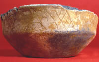
This Haley Complicated-Incised jar
excavated by in 1911 by C.B. Moore dates to the Middle
Caddo period and is a good example of the exuberant
experimentation in pottery making that is characteristic
of the period. Haley Place, Miller County, Arkansas.
From Moore's 1912 report, Some Aboriginal Sites on Red
River.
|
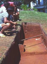
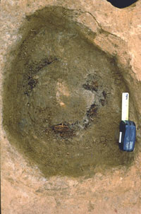
Students and visiting archeologist
discuss findings and look at engraved bowl uncovered
at the Reavely House Mound at the Washington Square
site in Nacogdoches, Texas. Photo courtesy Dee Ann Story.
|
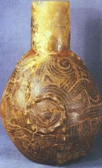
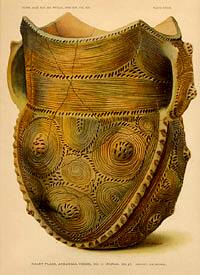
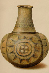
Ornate Haley Engraved bottle from
Middle Caddo Haley site, Miller County, Arkansas. Although
the decoration is exquisitely detailed, the paste and
firing of this pottery type is often inferior. Courtesy
Pictures of Record, Inc.
|
Untyped effigy bowl with engraved
designs. Effigy bowls may be another example of a Middle
Caddo introduction, probably from southwestern Arkansas.
Haley site, Miller County, Arkansas. Courtesy Pictures
of Record, Inc.
|
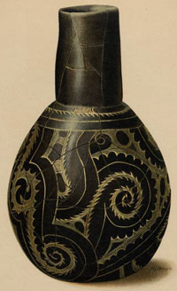
Haley Engraved bottle, Middle Caddo,
Haley site. From Moore, 1912.
|
|
The Middle Caddo period (A.D. 1200-1400)
was a time of changing settlement patterns, economic changes,
and exuberant experimentation with engraved and utilitarian pottery styles.
In fact, archeologists sometimes have difficulty recognizing
Middle Caddo sites as such because there are few well-defined
pottery styles. Compared to the Early Caddo pottery, which
looks very similar from place to place, the fine wares made
by Middle Caddo potters express far greater individuality
and creativity.
This upsurge in ceramic creativity during the
13th and 14th centuries coincides with the expansion of Caddo
settlements in many places across the homeland. A shift seems
to have taken place from a predominance of larger mound centers
like the Crenshaw and Davis sites to smaller communities including
small villages and hamlets as well as agricultural farmsteads.
This shift may be mainly a reflection of an economic shift
from a more diverse economy toward increasing reliance on
corn agriculture. Corn farming requires lots of space and
the growing crop must be closely watched, weeded, and, as
it matures, guarded to keep birds and mammals (especially
raccoons) from ravaging the corn. Many Caddo farmers moved to the
country, so to speak.
In recent decades archeologists have investigated
various large and small sites dating primarily to the Middle
Caddo period. They have found everything from small seasonal
campsites or single-family farmsteads that seem to lack substantial
houses and refuse middens to ritual (mound) centers that continue
many of the patterns seen at the Davis site (which continued
well into the Middle Caddo period). The larger sites were
important civic-ceremonial centers containing multiple mounds
and associated villages. The multiple mound centers are rather
evenly spaced along the Red River, the Sabine River, and Big
Cypress Bayou, and those that are contemporaneous may represent
an integrated regional network of interaction and redistribution.
For example, the Jamestown (eight mounds and village), Boxed
Springs (four mounds, village, and large cemetery), and Hudnall-Pirtle
(eight mounds and 60-acre village) sites appear to represent
the apexes (central places) of three Early and Middle Caddo
networks in the Sabine River basin.
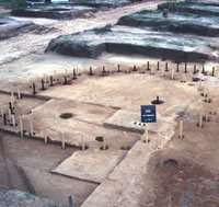
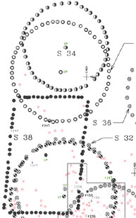
Among the premier mound centers in the Neches-Angelina
river basin, the Washington Square site in the
middle of what is today Nacogdoches, Texas, dates mainly to
the Middle Caddo period. The site once consisted of at least
three mounds separated by a long plaza area and with an associated
village. Most of the site has been destroyed as Nacogdoches
has grown. Two mound remnants have been partially excavated
by Jim Corbin and his students at Stephen F. Austin State University
and the 1985 field school of the Texas Archeological Society.
Extensive excavations documented a circular structure under
Mound 1/2, an assortment of pits and postholes in non-mound
contexts, and several large burial pits in a mortuary mound
(the Reavely-House Mound). Although little evidence of the
village apparently survives, large sherd-filled pits (representing
many vessels) were encountered in an area between the two
mounds. These are thought to be deposits from public feasting
activities led by the Caddo elite that used the Washington
Square site as a ceremonial center in the 13th and 14th centuries.
The Haley site is another ceremonial
center dating to the Middle Caddo period and one of the most
famous of all Caddo sites. It is located on a levee of the
Red River in southwestern Arkansas about 20 miles north of
the Louisiana state line. The Haley site had two prominent
mounds and probably once had other smaller mounds. C.B. Moore
excavated most of one mounds in 1912, finding nine shaft tombs
now known to date to the Middle Caddo period. He tested the
other mound and, finding no burials, concluded (probably correctly)
it was a "temple mound." Since the 1960s, amateur
archeologists and pothunters have found two sizable cemeteries
at the site and have dug up over 100 burials.
Although some archeologists have suggested that
Haley was strictly a "ceremonial and burial center,"
we suspect that associated village areas were close by. The
Haley site is best known for its unusually ornate pottery,
which exemplifies Middle Caddo pottery creativity. Tellingly,
many of the pottery styles found at Haley are known only from
a short stretch of the Red River Valley extending southward
into northernmost Louisiana. A few obvious trade pieces do
show up elsewhere, but the limited distribution area must
demark the territory of the local group (polity).
|
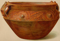
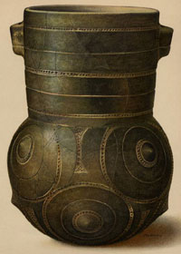
Large Haley Engraved bowl with handles
and protruding nodes, decorative flourishes that Caddo
potters began making in the Middle Caddo period. From
Moore, 1912.
Click images to enlarge
|
Trade vessel from the central Mississippi
Valley, probably Nashville Negative Painted, found by
C.B. Moore in a grave at the Middle Caddo Haley site.
From Moore, 1912.
|
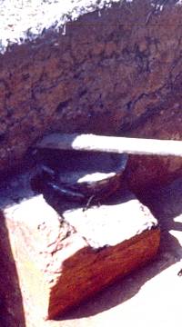
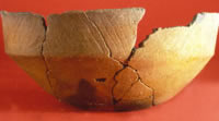
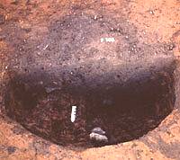
This engraved bowl is one of the
grave offerings of a Middle Caddo period burial that
was narrowly missed by a gas pipe in the front yard
of the Reavely House. Photo by Dee Ann Story.
|
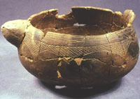
Handy Engraved bowl. The addition
of handles is another innovation of Middle Caddo potters.
Haley site, Miller County, Arkansas. Museum of the Red
River, Idabel, Oklahoma Courtesy Pictures of Record,
Inc.
|
Handy Engraved jar, Middle Caddo,
Haley site. From Moore, 1912.
|
|
|
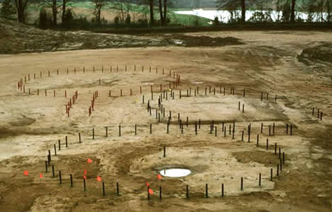
House and building outlines exposed
at the Oak Hill Village site. Courtesy PBS&J.
|
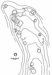
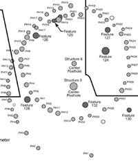
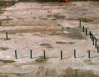
Plan of the Oak Hill Village. More
is now known about this site in Rusk County, Texas than
perhaps any other site dating to the Middle Caddo period.
Courtesy PBS&J.
|
|
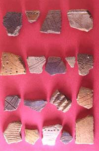
These
pottery sherds from Oak Hill Village show some of the
variation in pottery decoration present at the site. Courtesy PBS&J. |
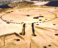
Overlapping circular house outlines.
Stakes of two colors mark the outline of the two houses.
Courtesy PBS&J.
|
The barely visible outline of Structure
2, a special building with an extended entranceway,
as it was first found. Late Village at Oak Hill site.
Courtesy PBS&J.
|
Outline of a "special building"
with extended entrance shortly after it was recognized
at the Oak Hill Village. This structure dates to the
Late Village. Courtesy PBS&J.
|
Close up of the wall trench on one
side of the entranceway to Structure 2. The narrow entranceway
had picket walls and two large posts at the entrance
to which wooden statues or emblems marking the building
as sacred space may have been attached. Late Village,
Oak Hill site. Courtesy PBS&J.
|
Two overlapping house outlines that
may represent a dilapidated house from which the timbers
were salvaged to build a second house on almost the
same spot. Middle Village, Oak Hill. Courtesy PBS&J.
|
Examples of the variety in size and
number of rows among the charred corn cobs from the
Oak Hill Village. Courtesy PBS&J.
|
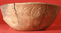
Variation on a Middle Caddo engraved
bowl #1. Oak Hill Village. Courtesy PBS&J.
|
Variation on a Middle Caddo engraved
bowl #2. Oak Hill Village. Courtesy PBS&J.
|
Variation on a Middle Caddo engraved
bowl #3. Oak Hill Village. Courtesy PBS&J.
|
|
Some 100 miles to the southwest from Haley,
a fascinating Middle Caddo village was discovered during archeological
investigations in advance of a large lignite (coal) surface
mine. The Oak Hill Village site in Rusk County, Texas,
occupied a small ridge overlooking Mill Creek, a tributary
of the Sabine River. More is now known about this Oak Hill
Village site in Rusk County, Texas than perhaps any other
site dating to the period. On behalf of TXU Mining Company
LP, archeologists from the private consulting firm PBS&J
used heavy machinery and hand excavation to open up broad
areas, and thus were able to expose the "footprint"
of virtually an entire small village. Postholes and pits dug
through the sandy soil into the underlying clay were visible
once large areas of the site were scraped off with machines
and then cleaned by hand. The ridge upon which the village
was built had been plowed and contoured by modern farming,
thus disturbing the upper deposits of the site.
Oak Hill Village had at least 42 circular and
rectangular structures representing at least three successive
villages. The structures that were part of the last and largest
village were arranged over a 3.5-acre area in a circular pattern
around a central plaza area. Sorting out which of the structures
were contemporaneous was very difficult because some of the
structures had been rebuilt over and over and some overlapped
earlier structures, particularly at the northwestern end of
the ridge and plaza. Working out how the village changed during
its 300-year span was also hard because most of the structures
were only recognized after the heavy machines had scraped
away what would have been the floor level (thus, removing
any evidence of the actual house floors and artifacts that
had survived modern plowing). Nonetheless, analysts were able
to work out the basic sequence of the village phases, called
here the early, middle, and late villages.
The Early Village at Oak Hill began as early
as A.D. 1150 (or perhaps a few decades later). It consisted
of four large rectangular structures, each measuring about
7 x 11 meters (23 x 36 feet). These are thought to be houses
that would have been suitable for 10-20 people. A total of
40-70 people probably lived at the site during this phase.
Rectangular houses are not common in the region, but are known
at other Middle Caddo sites, including the Ferguson site in Arkansas,
the Belcher site in Louisiana, and the Hines site in Wood
County, Texas. The early houses at Oak Hill were not arranged
around a plaza.
By A.D. 1250 the Middle Village had been reorganized
and the house style had changed from rectangular to circular
buildings like those typical of most Caddo sites in northeast
Texas. The middle village phase was the most intensive of
the three and lasted a full 100 years. Most of the superimposed
building patterns (most of them surely houses) date to this
phase. The exact number of houses in use at any one time is
unknown because of the overlapping outlines. The structures
making up the middle village at Oak Hill were arranged around
an open plaza covering at least 15 x 25 meters (about 50 x 80
feet). The total village population is estimated at between
75 and 100 people.
One of the clusters of three overlapping structural
patterns at the north end of the Middle Village was apparently
covered by a low mound, upon which a new building may have
been placed (the evidence was destroyed by plowing and machine
scraping). This mound probably covered a special building
of some sort, perhaps the house of the village headman or
a small temple.
During the Late Village phase, dating from about
A.D. 1350 to as late as 1450, the village expanded to the
south and new types of structures were built along with more
of the circular houses. Total village population is estimated
to have reached an all-time high of at least 100, perhaps
a bit more. Two of the new structures at the south end have
long extended entranceways pointing to the north (and the
main village area). These are clearly "special buildings"
although it is not known whether they were temples or the
houses of the village headman or priest. Also new during the
Late Village is the addition of interior partitions to several
buildings and the construction of four small circular structures
thought to be granaries.
Although the Oak Hill Village deserves a full TBH site exhibit, a few tantalizing details are presented below and in the accompanying photographs, based on the work of the archeologists who analyzed and reported the Oak Hill Village,
Robert Rogers and Timothy K. Perttula, and their colleagues.
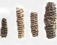
The main construction timber used throughout
the life of the Oak Hill villages was oak. There is no evidence
that any of the buildings were burned, suggesting that they
decayed naturally after use life of no more than 15 years.
One technique used to prolong the life of the upright timbers
was to char the ends of the posts that were set into the ground.
Some of the overlapping and intersecting house patterns suggest
that some of the houses were rebuilt using borrowed timbers
(perhaps those that had snapped off at the ground level).
Many charred corn cobs were found in several
pits within houses that were either cooking fires or what archeologists
call "smudge pits," fires intended to produce lots
of smoke either for smoking meat or keeping mosquitoes at
bay. The fragmentary cobs were studied by plant experts (paleobotanists)
who suspect the diverse sample represents as many as three
or four different varieties of corn. Eight, 10, 12, and 14-row forms were found, although the number of rows
is not clearly linked to variety (ears with different numbers
of rows occur within a single variety). While it was not possible
to identify these as known varieties, it does seem likely
that the Oak Hill villagers were growing several different
types of corn. This fits with early historic accounts that
describe the Hasinai groups growing an early maturing flint
corn and a later maturing flour corn. You can see the advantage
of having varieties that could be grown at different times
of the year and those that would tolerate drought better.
The 300-year span of the successive Oak Hill
villages illustrates nicely the increasing importance of corn.
Corn was found in 32% of the Early Village soil samples from
hearths and pits, 50% of the Middle Village samples, and 97%
of the Late Village samples. The Late Village granaries reinforce
these data. The village economy, though, depended on a mix
of crops, wild plants, and wild animals throughout the site's
history. Hickory nuts are present in almost every sample.
Other nuts include acorns and walnuts. Fruits that were eaten
include persimmons, dewberries, and grapes. The finding of
charred maygrass and goosefoot/pigweed indicates that these
starchy seeded weeds were probably grown (or encouraged) as
well. Deer was the hunter's favorite target and the main protein
source. Other hunted or trapped animals include rabbits, buffalo
(a single animal), and squirrel. Fish, birds, and reptiles
round out the list and that is only what was preserved. Dozens
of other plant and animal species would have been part of
the diet. 
|
Outline of a large rectangular house
dating to the Early Village at Oak Hill. Such houses
could have accommodated 10-20 people. Courtesy PBS&J.
|
Top of pit filled with charred corn
cobs. Archeologists usually call such features smudge
pits,out of the belief that these were fires intended
to produce lots of smoke either for smoking meat or
keeping mosquitoes at bay. Alternatively, they may be
cooking pits that used corn cobs for fuel. Courtesy
PBS&J.
|
Detail of the overlapping and superimposed
house outlines at the northwest end of the ridge at
the Oak Hill Village dating to the Early (rectangular)
and Middle (circular) villages. Courtesy PBS&J.
|
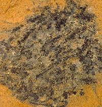
Large pit perhaps used for storage
and later filled with trash. Oak Hill Village. Courtesy PBS&J.
|
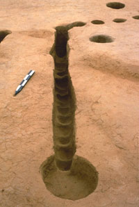
Remnants of the charred outer rind
of this oak post survived for over 600 years. The charring
was done to keep the post from rotting. Oak Hill Village.
Courtesy PBS&J.
|
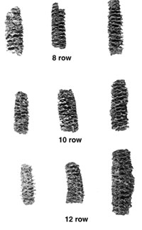
Eight, ten, twelve, and fourteen-row
corn cobs were found at Oak Hill Village. Although the
number of rows is not clearly linked to variety, plant
experts (paleobotanists) suspect the diverse sample
represents as many as three or four different varieties
of corn. Courtesy PBS&J.
|
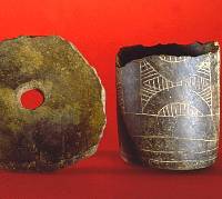
Large sherd disk of unknown function
and engraved cylindrical jar from Oak Hill Village.
Courtesy PBS&J.
|
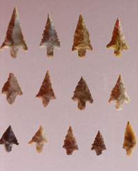
Perdiz arrow points from Oak Hill
Village. Courtesy Tim Perttula.
|
|
|
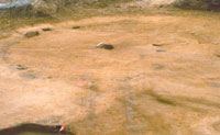
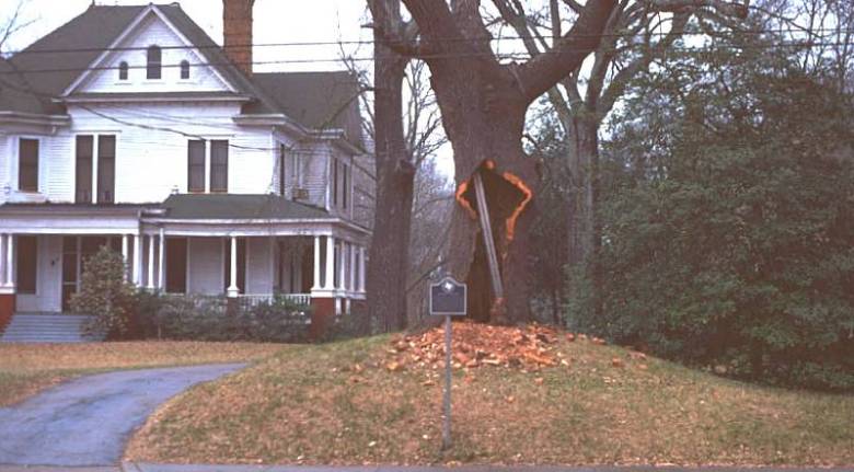 The old oak tree clinging to life at 516
North Mound Street in Nacogdoches, Texas guards what is left
of a burial mound dating to the Middle Caddo period, about
600-800 years ago. Long before the town was built, there was
a sizable Caddo community here. Ritual life centered around
three mounds forming a triangular plaza area. Photo by Dee
The old oak tree clinging to life at 516
North Mound Street in Nacogdoches, Texas guards what is left
of a burial mound dating to the Middle Caddo period, about
600-800 years ago. Long before the town was built, there was
a sizable Caddo community here. Ritual life centered around
three mounds forming a triangular plaza area. Photo by Dee