In this section:
|
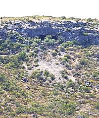
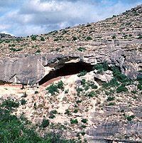
This small rockshelter is 41VV1—the
first formally recorded archeological site in Val Verde
County. It is one of hundreds of small shelters that
dot the Lower Pecos landscape. Prehistoric peoples found
these protected places useful for many different purposes.
This one is too small to have been lived in for long.
Photo from ANRA-NPS Archives at TARL.
|
|
As you read this, new rockshelters are forming ever
so slowly and old ones are crumbling. But most take
thousands of years to form, so you might not want to
wait around to watch.
|
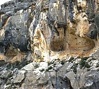
This series of small rockshelters
occur near the top of a high cliff overlooking the Devils
River. The shelters have small, steeply sloping floors
and they face west, making these shelters unsuitable
for habitation. But they were used as rock art galleries.
If you look close in the center of the picture you can
see an archeologist standing in front of an impressive
rock art panel featuring a panther with a curly tail.
As you might guess, this site is known as "Curly-Tailed
Panther." Its unusual and precarious location suggests
that this place was the scene of special rituals perhaps
including "vision quests" or similar phenomena.
Photo from ANRA-NPS Archives at TARL.
|
Hanging Cave, so named because it
seems to hang over this narrow channel, is also known
as No Goat Cave because it is one of few rockshelters
in the region that goats can't enter. This shelter is
larger than it looks and contains occupational debris
and several pictographs. Photo from ANRA-NPS Archives
at TARL.
|
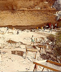
Early morning excavations get underway
at Baker Cave, a large rockshelter located in a side
canyon of the Devils River. Archeologists gingerly make
their way down the steep rocky slope to the relative
safety of the cave. Photo by Tom Hester.
|
Eagle Cave, near Langtry, contains
thick deposits of occupational materials especially
cooking debris—burned rocks, charcoal, and ash.
Photo by Steve Black.
|
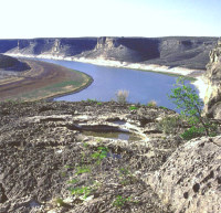
The lower Devils River valley as
viewed from the high cliff housing rockshelters with
pictographs. Photo by Steve Black.
|
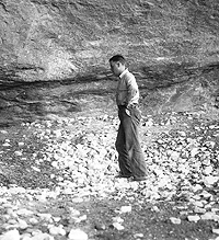
Man stands in "sotol pit"
in Fate Bell Shelter, 1932. This large rock-strewn depression
is a roasting pit where sotol, lechuguilla, and probably
other plants were baked. There were several such pits
visible in the shelter when the archeologists arrived.
Photo from TARL Archives.
|
Excavations in progress at Baker
Cave, 1984. Photo from TARL Archives.
|
Archeologist Mark Parsons stands
in one of the many looter holes that left the interior
of Fate Bell Shelter looking like a World War I trench
warfare scene. The brown layers and patches are plant
fiber deposits of no interest to artifact collectors
but very informative for archeologists. The back of
the shelter is blackened by countless fires and also
covered in pictographs, so many that they were often
painted on top of one another. In fact, archeologists
began to determine the relative ages of different styles
of rock art by noting which style was covered by another.
Photo from TARL Archives.
|
|
Much of what we know about the ancient peoples
who lived in the Lower Pecos Canyonlands comes from rockshelters, places
where people sometimes lived and carried out both the mundane
and the sacred aspects of life. This section presents numerous
pictures of Lower Pecos rockshelters, explains rockshelter
basics, and introduces some of the better-known shelters.
What are rockshelters and how do they
form?
Rockshelters (or just shelters) are natural
overhangs or shallow caves that form on cliff faces and other
steep rocky exposures. They can form through wind erosion,
water erosion, and the dissolution of soft layers of rock.
Technically, rockshelters are wider than they are deep and
caves are deeper than they are wide, but this distinction
is frequently ignored. Many rockshelters are called caves
and we tend to use whatever name has stuck. The prehistoric
peoples of the Lower Pecos Canyonlands did make limited use of some true
caves also, but most caves in the area are not readily accessible
and are often very narrow, underground places ill suited for
human occupation. Rockshelters, on the other hand, often furnished
quite comfortable living quarters—big rooms with a view.
The Lower Pecos area contains hundreds of rockshelters.
They are common in the region for two reasons. First, the
right kind of rock—the area is part of a enormous expanse
of limestone called the Edwards Plateau that extends all across
the Texas Hill Country and beyond. Second, the vast network
of canyons provides the vertical rock faces needed for rockshelters
to form. The process of rockshelter formation can be complex
and it differs from spot to spot depending on such factors
as the direction the cliff faces, the prevailing wind direction,
the hardness of each rock formation, the distance to the nearest
stream, and so on. It is a continuous process that happens
on a geological time scale. As you read this, new rockshelters
are forming ever so slowly and old ones are crumbling. But
most take thousands of years to form, so you might not want
to wait around to watch. If you could, here is what you would
see.
In the Lower Pecos Canyonlands, rockshelters often form
in places where a layer of softer rock is sandwiched between
two harder layers. Because the softer materials erode faster
when exposed to the natural elements (wind, sun, and water),
a hollow begins to form. The hard layer above becomes the
roof of the rockshelter and the hard layer below becomes its
floor. As the back of the shelter and its roof weathers, "spalls"
or chunks of rock break off and fall to the floor of the shelter.
In cold wet winter weather, the process speeds up. Moisture
in cracks in the wall or roof expands when frozen and then
contracts when thawed. This cycle—expand, contract, expand,
contract—causes more spalls to break off from the roof
and wall and the rockshelter becomes larger and deeper. Eventually,
the hard layer that forms the roof becomes undercut too much
by the deepening shelter and the whole layer may collapse,
destroying the rockshelter.
Most of the rockshelter formation process actually
occurs at a microscopic level—tiny particles of rock
constantly trickle down, faster in soft rock, slower in hard
rock. These tiny particles form "cave dust"—a
fine off-white powder resembling unbleached flour. The spalls
and cave dust fall to the floor of the rockshelter. What happens
next depends on where the rockshelter is located and whether
its floor is flat or sloping. Some shelters have floors that
are steeply sloped outward such that anything falling on the
floor quickly tumbles to the canyon floor. Other rockshelters
have more or less flat floors and as roof spalls and cave
dust falls, it accumulates on the floor. Unless, that is,
the rockshelter is located at the base of a cliff beside a
stream, where anything resting on the floor is periodically
scoured out by floodwater.
Now for the part that draws the archeologist—the
stuff inside the rockshelters and on the walls. Many of the
occupied rockshelters in the Lower Pecos have more or less
flat floors and are located high above flood level. In these
places, the rockshelters slowly fill up with deposits of natural
materials— roof spalls and cave dust, mixed with cultural
materials—anything humans make or bring in. And people
living in rockshelters hauled in plants, tools, tool-making
materials, containers, food, rocks, firewood, and more. Over
time, some rockshelter deposits have grown to over 30 feet
thick just during the time span that humans lived in the region
(the last 13,000 years or so). Archeologists get excited when
we excavate rockshelters because we often find well-preserved
organic materials (see below) and as we peel back the layers,
one by one, evidence comes to light from earlier and earlier
periods of time. That, and the fact that the shelter walls
are often covered with bright multi-colored pictographs depicting
animals, humans, and many symbols whose meaning is not obvious.
Why were some rockshelters occupied and
not others?
As the photographs in this section show, no
two rockshelters are the same. Some are much larger than others,
some occur at the bottom of a cliff, others at the top, and
so on. In general, people, of course, chose to live in the
larger ones located near areas where water, food sources,
and other basic necessities were readily available. They favored
those with flat floors and those that faced in certain directions.
And this would have changed from season to season. For example,
in the hot summer, a rockshelter that faces (opens toward)
the west and the setting sun is not a very comfortable place
to be. Similarly, in the winter, shelters facing north are
much colder and windier than those facing south. This probably
explains why the rockshelters with the most abundant evidence
of occupation are those that face east or south.
We know which rockshelters were favorite places
to stay because they are full of evidence of daily life—trash,
mostly. And in the rockshelters of the Lower Pecos Canyonlands the trash
contains all sorts of organic materials that are not preserved
in most archeological sites. Dried plants, fibers, seeds,
nuts, leaves, roots, sticks, bone, leather, wood, and all
kinds of things made out of these materials. Baskets, mats,
ropes, nets, blankets, robes, digging sticks, atlatls, darts,
fire-drills, snares, pouches, sandals, and many more "perishable"
artifacts. We also find cooking pits, grass beds, latrines,
warmth hearths, and other kinds of features. Such things can
last for 5,000 to 6,000 years in the right environment. In
the Lower Pecos this means a well-protected rockshelter that
stays dry.
One of the things that people routinely did
in certain rockshelters was to cook plant foods—roots
and bulbs mostly—in large cooking pits called roasting
pits or earth ovens. Earth ovens are layered arrangements
of heated rocks, plants, food, and earth that roast or bake
food slowly—often over 2-3 days time. Not just any food,
but mainly root foods like the hearts (bulbs) of the lechuguilla
and sotol plants—inedible raw, after prolonged cooking
they turn to a sugary carbohydrate. Most earth ovens were
constructed outside in open sites archeologically identified
as burned rock middens—piles of fire-cracked rock that
accumulated around roasting pits. But in the Lower Pecos Canyonlands,
earth ovens were also built inside certain rockshelters. Why?
The most likely explanation is the shelters mainly were used
for cooking during periods of wet or very cold weather when
earth ovens would be difficult to build in the open.
Other shelters weren't used for everyday living
or cooking, but for special purposes. For example, there are
a series of shallow rockshelters located almost at the top
of an enormous cliff overlooking the Devils River. Most of
these are small and they have steep floors where nothing rests
for long. While these were useless as places to live, their
walls are covered with rock art. These were obviously special,
sacred places where rituals took place or were at least evoked
by the painted symbols such as that of a panther with an unnatural
"curly" tail.
When you visit one of these hard-to-reach places
high above the canyons, the view is spectacular and awe-inspiring.
It doesn't take much imagination to conjure up the "vision
quests" and other extraordinary experiences that small
groups of prehistoric peoples took part in there. While we'll
never know the details, we can see patterns in the location
of such places, the types of associated symbols, and sometimes
artifacts.
Another type of special purpose rockshelter
is that used for human burials. Sometimes burials are found
in ordinary rockshelters full of evidence of everyday life.
The burials are usually placed in the backs of the shelters
or in small chambers or other out-of-the-way places. In other
cases, people sought out small, remote shelters and crevices
as burial places, perhaps in hopes these would not be disturbed.
Lower Pecos Rockshelters
Fate Bell Shelter was one of the first
rockshelters in the Lower Pecos Canyonlands to be excavated by a professional
archeologist. A.T. Jackson carried out relatively modest excavations
there in 1932 on behalf of the University of Texas and its
archeological leader, Professor James E. Pearce. His excavation
report was the first reasonably detailed description of a
rockshelter. Several years later he published a study called
Picture Writing of Texas Indians that described the
pictographs found at Fate Bell and dozens of other localities
in the Lower Pecos and elsewhere in Texas.
Fate Bell Shelter is massive, stretching over
150 yards from one "end" to the other, but narrow,
only 40 feet or so at its widest point. It was used as an
habitation site, a cooking place, a burial place, and as a
rock art gallery. The thick deposits once contained a wealth
of information, but, sadly, most of the cave was dug up by
untrained people intent on finding showy artifacts. In the
1970s the property became part of Seminole Canyon State Park
and the site is now protected by law. Visitors to the park
can take special guided tours of Fate Bell Shelter, an unforgettable
experience.
Hinds Cave, located in a side canyon
off the Pecos River, is one of the most carefully studied
rockshelters. It was excavated in the 1970s by archeologists
from Texas A&M. They were particularly interested in human
ecology—how people interact with the environment. Professors
and graduate students undertook many different kinds of specialized
studies. One of the most informative types of research was
coprolite analysis. Coprolites are dried human feces—when
"reconstituted" by adding water, even 4,000-year-old
specimens smell just like the original. This may be more than
you wanted to know, but coprolite analysis gives a direct
picture of the ancient human diet. You won't be shocked to
learn that it was the graduate students who were assigned
to analyze the coprolites.
Baker Cave is on a small side canyon
off the Devils River. It, too, has been carefully studied
by several different projects. One of the most astonishing
findings there was a large cooking hearth that dates to about
9,000 years old during what is often called the Late Paleoindian
period. The hearth was chock full of bones, but not the bones
of bison or other large animals. Instead, there were snakes,
rats, fish, rabbits, and many other small creatures as well
as various charred seeds and nuts. This shows that by this
time people were already making use of virtually everything
that was edible.
Bonfire Shelter in Mile Canyon, a short
box canyon that empties directly into the Rio Grande near
Langtry, is probably the most famous Lower Pecos rockshelter.
It is famed because it was the scene of a series of buffalo
"jumps" beginning as early as 12,000 years ago or
maybe even earlier. You can read all about it in the Bonfire
exhibit.
Panther Cave is a "high lonesome"
shelter situated on a cliff overlooking the Rio Grande at
the mouth of Seminole Canyon. This cave is known for its spectacular
rock art, especially a huge red panther (mountain lion). This
site lies within the boundaries of the Amistad National Recreation
Area and is protected by federal law. It is managed jointly
by the National Park Service and the Texas Parks and Wildlife
Department. With a good pair of binoculars, the famous panther
can be seen from the scenic overlook trail in Seminole Canyon
State Park. When lake levels allow, special guided tours can
be arranged through Seminole Canyons State Park. Sadly, vandalism
forced the NPS to erect a heavy chain link fence to protect
the cave.
Coontail Spin Cave is a relatively small,
narrow rockshelter that is important because of the archeological
excavations done there in 1962. According to archeologist
Ed Jelks who supervised the Amistad Reservoir investigations,
the shelter takes its name from the local nickname for the
western diamondback rattlesnake—coontail—the dark
bands around the snake's tail are reminiscent of a coon's
tail. The "spin" describes the winding trail the
archeologists followed up and down the canyon walls to reach
Coontail Spin Cave. The results of work at this site will
be featured in a future exhibit on Texas Beyond History.
White Shaman Cave is a very small rockshelter
on a tiny side canyon of the Pecos River, not far from the
Pecos River Bridge. Small perhaps, but this shelter is famous
because of the evocative image of … you guessed it, a
white shaman. Actually, the "white shaman" is an
anthropomorphic figure of the type called "shamans,"
but the meanings of these figures are debated. (See
Rock Art.) This site is now owned and protected by the
Rock Art Foundation and can be visited on one of the regularly
scheduled tours. The climb in and out of White Shaman Cave
is not for the faint of heart, but the vivid pictographs and
intimate setting are truly remarkable.
|
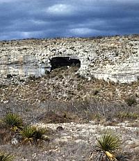
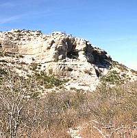
Rockshelters form in limestone cliffs
and vertical faces where softer or fractured layers
of rock occur. These layers erode faster than the harder,
more resistant surrounding rock and, over time, become
prominent shelters such as this one. Photo from ANRA-NPS Archives at TARL.
|
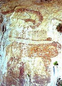
The Curly-Tailed Panther painted
on the rear wall of an almost inaccessible rockshelter
high on a cliff overlooking the Devils River. Photo
by Steve Black.
|
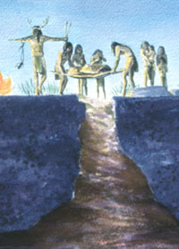
This scene depicts a burial at Seminole
Sinkhole, a natural cave formed by a solution cavity
in the limestone bedrock. Such places probably had great
symbolic importance as openings to the underworld. The
deceased was lowered into the narrow sinkhole opening
perhaps with the idea that in doing so, he or she could
join ancestors in the world beyond the living face of
the earth. Mural by Nola Davis, courtesy of the Texas
Parks and Wildlife Department.
|
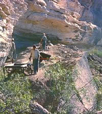
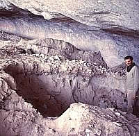
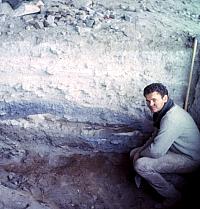
Excavations underway at Coontail
Spin Cave in 1962. Access to this cave was extremely
challenging because of its remote location. Archeologists
reached it by descending a long, steep slope from the
opposite canyon wall and then climbing up a narrow tortuous
path to the cave. Photo from ANRA-NPS Archives at TARL.
|
|
Over time, some rockshelter deposits have grown
to over 30 feet thick just during the time span that
humans lived in the region.
|
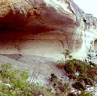
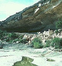
Even at a distance, a trained eye
can spot the tell-tale signs of intense human occupation.
The gray fan-like talus deposits below this rockshelter
may look like the result of mining, but this is actually
cooking debris—literally tens of tons of fire-fractured
limestone rocks mixed with charcoal and ash. These "burned"
rocks are spent cooking stones rejected after they broke
into pieces too small to be useful. They are the result
of the use of this shelter for earth oven cooking on
countless occasions. For scale, the opening of this
shelter is about 10-12 feet high and perhaps 50 feet
wide. Photo by Phil Dering.
|
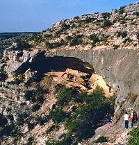
Fate Bell Shelter in Seminole Canyon
is one of the largest rockshelters in the Lower Pecos.
It was partially excavated by A.T. Jackson in 1932 and
briefly tested by Mark Parsons in 1963. In between and
afterward, much of the cave was churned up by looters.
The walls of the shelter are covered with hundreds of
pictographs. Today this shelter is protected within
Seminole Canyon State Park. It can be visited on regular
tours led by the Park Rangers. Photo courtesy of Texas
Parks and Wildlife Department.
|
Hinds Cave is located on a side canyon
off the Pecos River. It was excavated by archeologists
from Texas A&M University in the 1970s. Photo by
Phil Dering.
|
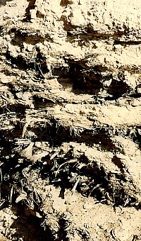
Fiber layers in upper deposits at
Baker Cave. This is typical of many of the dry caves
in the Lower Pecos Canyonlands. The upper deposits, 2-6 feet thick,
are mainly plant fiber from food refuse, bedding, wooden
and fiber-tool making, etc. This presents a real problem
to the archeologist—what do you keep? The whole
deposit?
|
Archeologist Mark Parsons exposes
a fiber layer in an undisturbed area of Fate Bell Shelter.
The distinctly colored and textured layers visible in
the excavation wall represent different episodes in
the shelter's long history of intermittent human occupation.
Generally speaking, the dark layers are associated with
intense occupation, while the light colored layers are
mostly cave dust and roof spalls from periods when the
shelter (or just this part of it) wasn't used by humans.
Photo from TARL Archives.
|
|